Event created by Russell D - 1104622

Event Details
Simulation Date/Time : Current date set to daylight.
Weather : Real World / Fair weather if real world is unsuitable for VFR operations.
Distance : 200 nm
Est Flight Time : approx 85 mins
Aircraft : Single or twin engine aircraft such as Mooney Bravo, Beechcraft Baron or similar capable of 150 to 175 kias.
Communications : Australia uses CTAF (Common Traffic Advisory Frequency) for radio comms at uncontrolled airfields. VATSIM pilots connecting to the network using FSCOPILOT/FSINN can install an additional file that provides the ability to tune the CTAF frequency and make voice announcements to other pilots on frequency. These files can be obtained via this link.
For pilots connecting to VATSIM using VPilot, there is a work around that enables these pilots to also take advantage of online voice CTAF. Refer to this informative VATPAC Forum post to learn how to implement the work around.
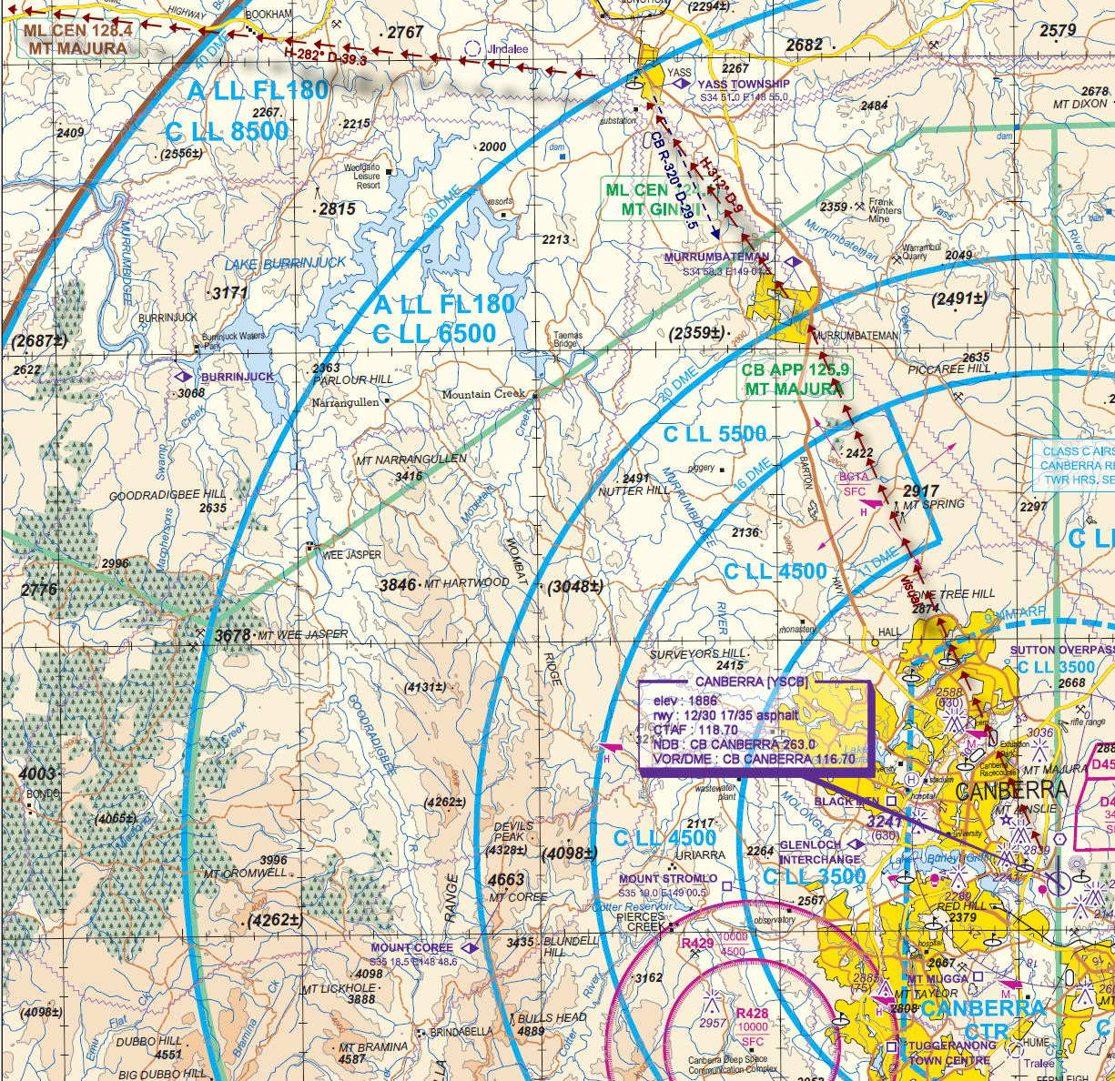
Altitude : Once clear of Canberra Control Zone, remain below the class C steps and not above FL125
Flightplan
File as : YSCB MMM ASST COOTAMUNDR YCTM YTEM YWWL YGTH
GPS Flightplan is available for FSX and X-Plane FMS and also provided is the original Plan-G flightplan for those that find this useful all enclosed within a Zip archive.
Navigation : Pilots have a choice of alternatives for this flight. There is the obligatory accompanying flight plan for those that embrace the latest technology. For the more adventurous pilots the radial and distances are provided allowing the flight to be navigated using ground based radio and visual navigation techniques.
Recommended Scenery
Flight Details
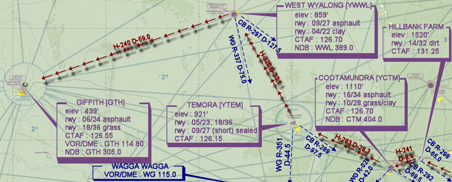
Navigation VOR/DME WG Wagga - 115.00
-
CANBERRA [YSCB] Takeoff
elev : 1886
rwy : 12/30 17/35 asphalt
CTAF : 118.70
NDB : CB CANBERRA 263.0
VOR/DME : CB CANBERRA 116.70 -
MURRUMBATEMAN [MMM] Overfly - H-325° D-21.8 nm
pos : CB R-323° D-20 -
YASS TOWNSHIP [ASST] Overfly - H-312° D-9 nm
pos : CB R-320° D-29.5 -
HILLBANK FARM T&G - H-282° D-39.3 nm
pos : CB R-298° D-65 WG R-034° D-49.5
elev : 1520
rwy : 14/32 dirt
CTAF : 131.25 -
COOTAMUNDRA [YCTM] T&G - H-241° D-8.4 nm
pos : CB R-292° D-69.5 WG R-028° D-42.0
elev : 1110
rwy : 10/28 16/34 asphalt
CTAF : 126.70 -
TEMORA [YTEM] T&G - H-283° D-28.3 nm
pos : CB R-289° D-97.5 WG R-351° D-44.5
elev : 921
rwy : 09/27 18/36 05/23 asphalt
CTAF : 126.15 -
WEST WYALONG [YWWL] T&G - H-320° D-33.1 nm
pos : CB R-297° D-127.5 WG R-337° D-75.0
elev : 859
rwy : 04/22 09/27 asphalt
CTAF : 126.70 -
GRIFFITH [YGTH] Land - H-240° D-58.9 nm
elev : 439
rwy : 18/36 06/24 asphalt
CTAF : 126.55
NDB : GTH GRIFFITH 305.0
VTC Chart
WAN Chart