

Event created by Russell D - 1104622

Event Details
Simulation Date/Time : Current date set to daylight.
Weather : Real World / Fair weather if real world is unsuitable for VFR operations.
Distance : 175 nm
Est Flight Time : approx 80 mins
Aircraft : Single or twin engine aircraft such as Beechcraft Baron, Mooney Bravo or similar capable of 155 to 185 kias.
Communications
Australia uses CTAF (Common Traffic Advisory Frequency) for radio comms at uncontrolled airfields.
FSCopilot/FSInn
VATSIM pilots connecting to the network using FSCOPILOT/FSINN can install an additional file that provides the ability to tune the CTAF frequency and make voice announcements to other pilots on frequency. These files can be obtained via this link.
Swift
Swift is a recent VATSIM Pilot Client alternative now released to the public as a beta release candidate. This pilot client is a one fits all alternative and will work with FSX, P3D V3/V4 and XPlane in either 32 bit Windows or 64 bit Windows, Mac and Linux. This client, once installed and configured (not for the faint of heart - some guidance can be found in this video tutorial for those with X-Plane on Windows x64), also provides a capability for pilots to designate a private voice channel to allow communication with other pilots in the same voice channel. However, to do this requires a frequency over ride to be set allowing the client to ignore the set frequency instead providing text entry into a text box. Into this box the name of the voice room needs to be entered to enable voice communication. A voice room is typically in the form of "some.server.org/<Airport ICAO>". The server component is ALWAYS "rw1.vatpac.org". So this week's departure would use "rw1.vatpac.org/<Airport ICAO>".
For airports without an airport ICAO it is typical to use VATPAC VFR Virtual voice room acccessed using 131.25 in FSINN. The equivalent for SWIFT is "rw1.vatpac.org/virtualvfr".
Altitude : Not above FL125
Flightplan
File as : YMMB VFR.COASTAL ALTS TON BMP YBLT YARA YWBL
GPS Flightplan is available for FSX and X-Plane FMS and also provided is the original Plan-G flightplan for those that find this useful all enclosed within a Zip archive.
Navigation : Pilots familiar with the area can navigate visually, for those less familiar the accompanying GPS Flightplan is the recommended method of navigating the flight plan.
Recommended Scenery
FSX / P3D
- Warrnambool Airport YWBL - Colin Jeffery
- YARA YSWL YMBU YSTA YDOD YWYF YBIR YHPN YKER YSLK YSWH - Colin Jeffery
- ORBX Australia
- ANTS AUSSIE AIRPORTS
- OZX 3.5 AU Scenery
X-Plane 10/11
Flight Details
* NOTE Frequency 131.25 - "rw1.vatpac.org/virtualvfr"
-
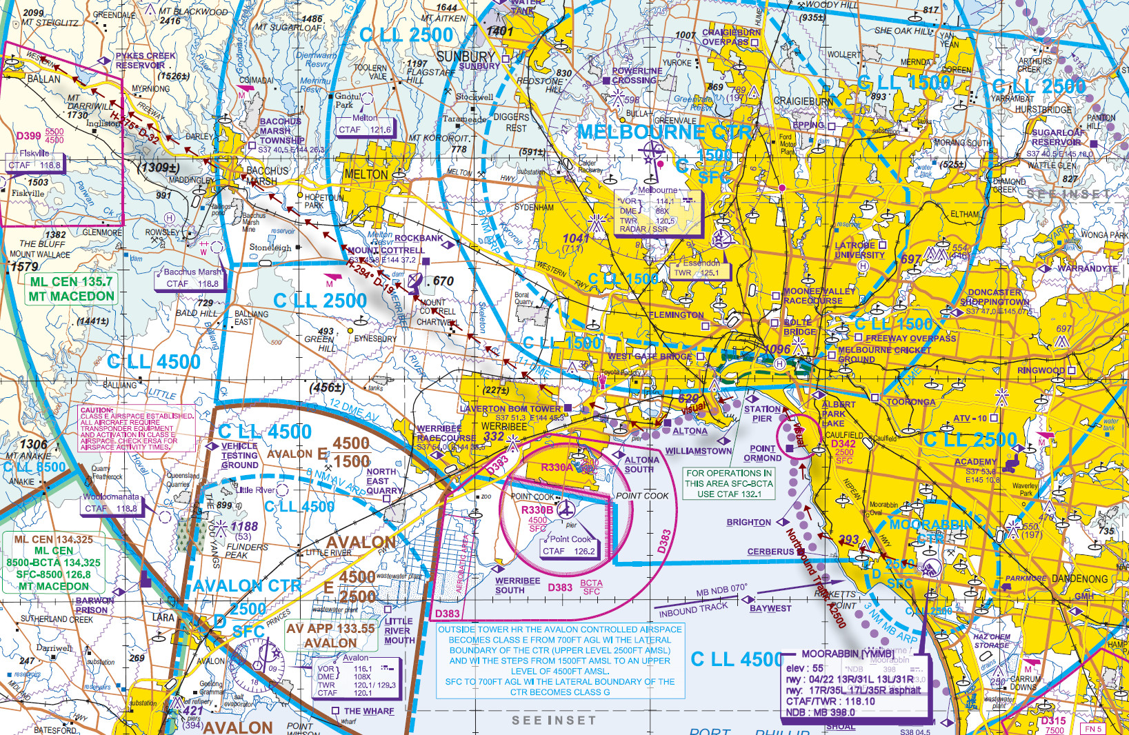
MOORABBIN [YMMB] Takeoff
elev : 55
rwy : 04/22 13R/31L 13L/31R 17R/35L 17L/35R asphalt
CTAF/TWR : 118.10
NDB : MB MOORABBIN MELBOURNE 398.0 -
ALTONA SOUTH [ALTS] Overfly - VFR Route coastal D-15 - A2500
-
LAVERTON BOM TOWER [TON] Overfly - VFR Route D-3
-
BACCHUS MARSH TOWNSHIP [BMP] Overfly - H-294° D-19
-
BALLARAT [YBLT] T&G - H-275° D-32
elev : 1433
rwy : 18ns/36 05/23 asphalt
rwy : 13ns/31 grass
CTAF : 127.75 (FSINN 126.00) -
ARARAT [YARA] T&G - H-276° D-40
elev : 1008
rwy : 12/30 asphalt
rwy : 04/22 grass
CTAF : 126.70 -
WILLAURA Overfly - H-210° D-18
-
CHATSWORTH [YCWO] T&G - H-187° D-19
(Scenery not depicted in P3D)
elev : 629
rwy : 01/19 grass
CTAF : 122.80 (FSINN 131.25) -
WARRNAMBOOL [YWBL] Land - H-186° D-28
elev : 242
rwy : 04/22 gravel
rwy : 13/31 asphalt
CTAF : 126.00
Melbourne VTC
Victorian VNC
