Event created by Russell D - 1104622

Event Details
Simulation Date/Time : Current date set to daylight.
Weather : Real World / Fair weather if real world is unsuitable for VFR operations.
Distance : 102.6 nm
Est Flight Time : approx 80 mins
Aircraft : Single engine piston aircraft with short field capability such as Orion Maule, Pilatus PC-6 Porter or similar capable of 105 to 135 kias.
Communications : Australia uses CTAF (Common Traffic Advisory Frequency) for radio comms at uncontrolled airfields. VATSIM pilots connecting to the network using FSCOPILOT/FSINN can install an additional file that provides the ability to tune the CTAF frequency and make voice announcements to other pilots on frequency. These files can be obtained via this link.
For pilots connecting to VATSIM using VPilot, there is a work around that enables these pilots to also take advantage of online voice CTAF. Refer to this informative VATPAC Forum post to learn how to implement the work around.
Altitude : Not above FL125
Flightplan
File as : YDAY YMCF YBWW YTWB YWCK
GPS Flightplan is available for FSX and X-Plane FMS and also provided is the original Plan-G flightplan for those that find this useful all enclosed within a Zip archive.
Navigation : Pilots familiar with the area can navigate visually, for those less familiar the accompanying GPS Flightplan is the recommended method of navigating the flight plan.
Navigation : Pilots have a choice of alternatives for this flight. There is the obligatory accompanying flight plan for those that embrace the latest technology. For the more adventurous pilots the radial and distances are provided allowing the flight to be navigated using ground based radio and visual navigation techniques.
Recommended Scenery
Flight Details
-
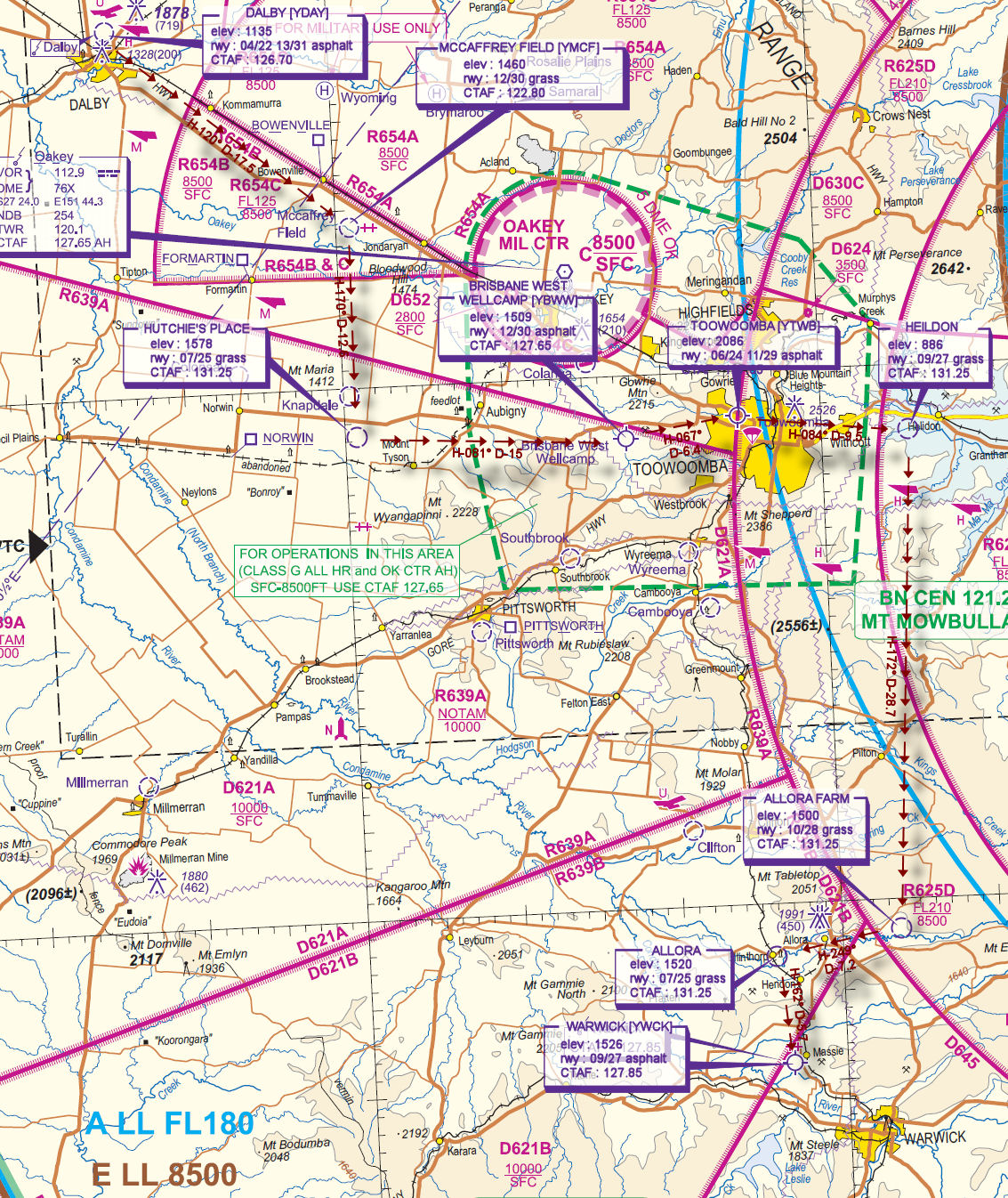
DALBY [YDAY] Takeoff
elev : 1135
rwy : 04/22 13/31 asphalt
CTAF : 126.70 -
MCCAFFREY FIELD [YMCF] T&G - H-120° D-17.5 nm
elev : 1460
rwy : 12/30 grass
CTAF : 122.80 -
HUTCHIE'S PLACE Stop & Go - H-170° D-12.6 nm
elev : 1578
rwy : 07/25 grass
CTAF : 131.25 -
BRISBANE WEST WELLCAMP [YBWW] T&G - H-081° D-15 nm
elev : 1509
rwy : 12/30 asphalt
CTAF : 127.65 -
TOOWOOMBA [YTWB] T&G - H-067° D-6.4 nm
elev : 2086
rwy : 06/24 11/29 asphalt
CTAF : 127.65 -
HEILDON T&G - H-084° D-9.5 nm
elev : 886
rwy : 09/27 grass
CTAF : 131.25 -
ALLORA FARM T&G - H-172° D-28.7 nm
elev : 1500
rwy : 10/28 grass
CTAF : 131.25 -
ALLORA T&G - H-249° D-7.2 nm
elev : 1520
rwy : 07/25 grass
CTAF : 131.25 -
WARWICK [YWCK] Land - H-162° D-5.7 nm
elev : 1526
rwy : 09/27 asphalt
CTAF : 127.85
Chart