Event created by Russell D - 1104622

Event Details
This week VFR Operations flies between Moorabbin and Stawell. For the Friday flight, VFR Operations will conduct a "Fly in/Fly out" of the Avalon airshow enroute. As such, the flight is to be conducted in two parts. The first from Moorabbin to Avalon where at the completion of that flight a complete reset occurs prior to conducting the next leg Avalon to Stawell.
It is a strong recommendation that pilots undertake some familiarisation with the approaches and departures around Avalon prior to participating in this event. Should there be an ATC presence pilots will be expected to understand the relevant procedures.
Simulation Date/Time : Current date set to daylight.
Weather : Real World / Fair weather if real world is unsuitable for VFR operations.
Distance : 164 nm over two legs.
Est Flight Time : approx 85 mins
Aircraft : Single or twin engine aircraft such as Beechcraft Baron, Mooney Bravo or similar capable of 155 to 185 kias.
Communications : Australia uses CTAF (Common Traffic Advisory Frequency) for radio comms at uncontrolled airfields. VATSIM pilots connecting to the network using FSCOPILOT/FSINN can install an additional file that provides the ability to tune the CTAF frequency and make voice announcements to other pilots on frequency. These files can be obtained via this link.
For pilots connecting to VATSIM using VPilot, there is a work around that enables these pilots to also take advantage of online voice CTAF. Refer to this informative VATPAC Forum post to learn how to implement the work around. Similarly, this work around has been reported to be successfully adopted for X-Plane using the X-Squawkbox client. As of yet there are no available instructions for doing this.
Altitude : remain outside Melbourne controlled airspace
GPS Flightplan is available for FSX and X-Plane FMS and also provided is the original Plan-G flightplan for those that find this useful all enclosed within a Zip archive.
Navigation : Pilots familiar with the area can navigate visually, for those less familiar the accompanying GPS Flightplan is the recommended method of navigating the flight plan.
Recommended Scenery
-
ORBX Avalon [YMAV] (FSX/P3D)
Activate airshow mode to enable YAVE runways and taxiways - Mid west Victoria - YARA YSWL YMBU YSTA YDOD YWYF YBIR YHPN YKER YSLK YSWH - Colin Jeffery (FSX/P3D)
- ORBX Australia (FSX/P3D)
- ANTS AUSSIE AIRPORTS (FSX/P3D)
- OZX 3.5 AU Scenery (FSX/P3D)
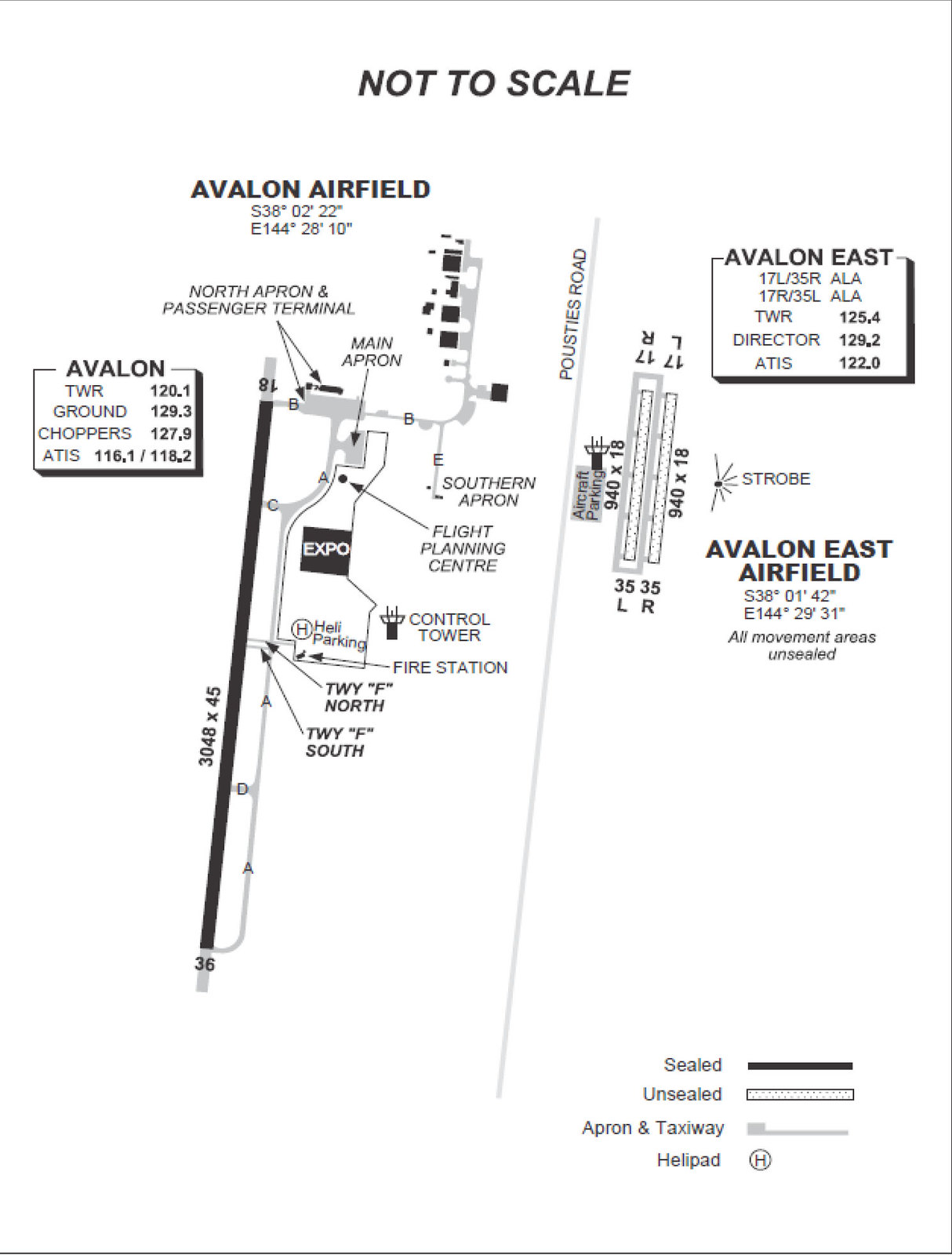
Avalon and Avalon East Airport Information
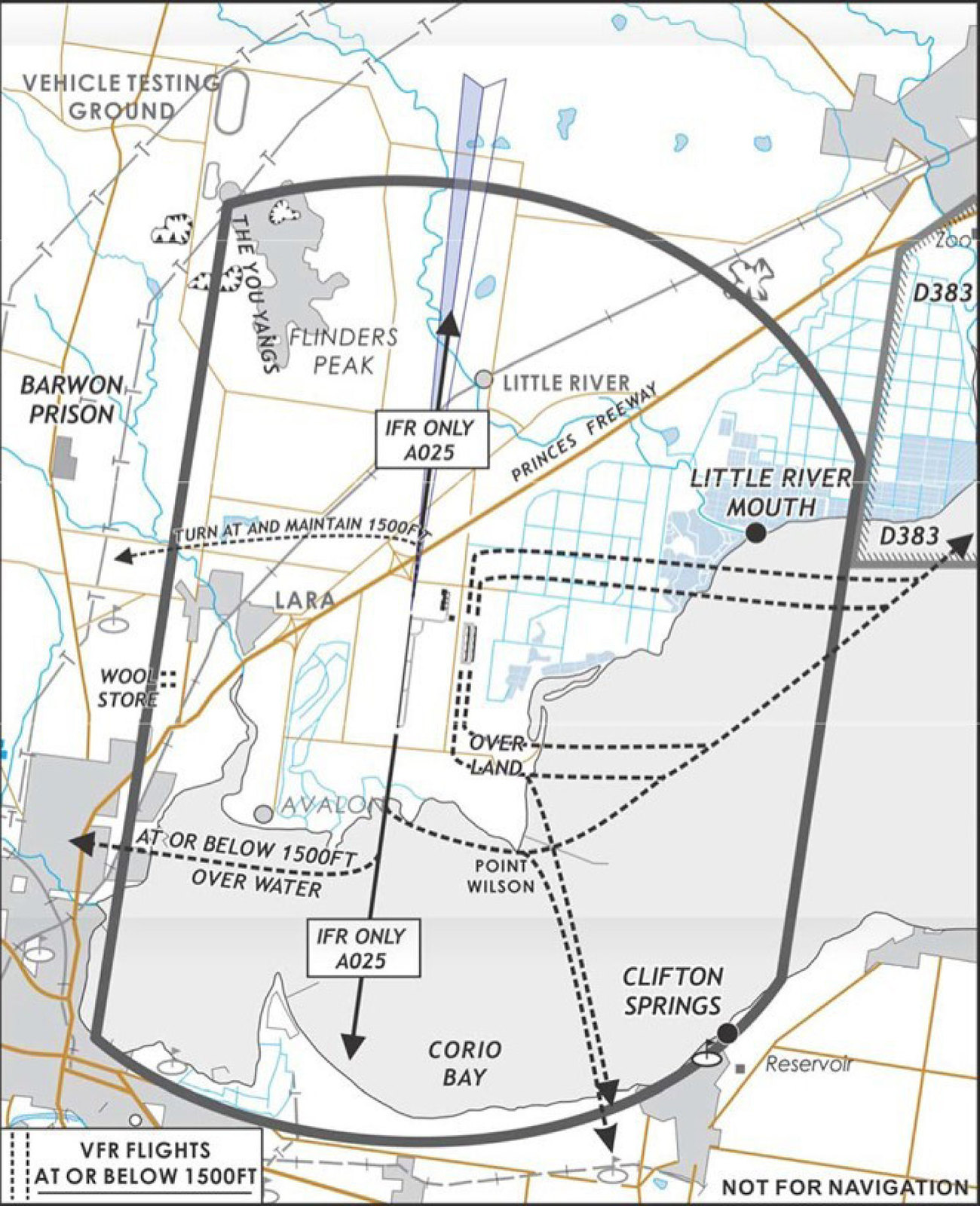
YAVE is a temporary grass/unsealed aerodrome established 2KM east of the main YMAV runway. It consists of two parallel strips and associated taxiways as depicted in charts below.
YAVE is for the exclusive use of Day VFR fixed wing aeroplanes of 5,700KG MTOW or less including approved recreational aircraft, operating to the EAST of Pousties Road, and SOUTH of the Princes Freeway (DO NOT CROSS THE FREEWAY) - SFC to 1,500FT.
Strobe lighting is located to the east of RWY 17L/35R, visible in the eastern sector from about 340° clockwise to 180°.
Airport Diagram
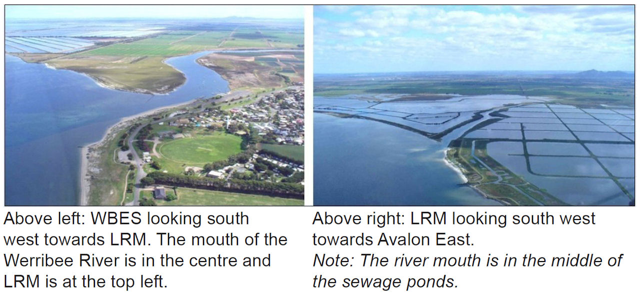
Holding Circuits and paths for entering YAVE runways 17L/R & 35L/R. Initial approach fix is Little River Mouth
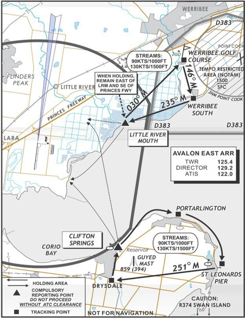
Entry to YMAV runways 18 & 36. Initial approach fix is Werribee South
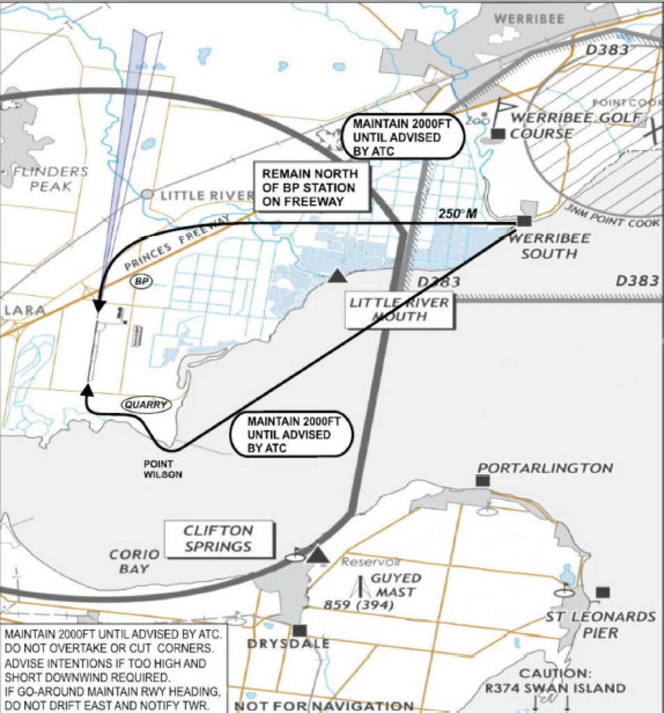
Visual approach points of Werribee South and Little River Mouth
Leg 1 - Moorabbin to Avalon/Avalon East
Flightplan
Active GPS flighplan "YMMB-YMAV_YAVE"
With YAVE Scenery - File as : YMMB APL SNP ALTS WBES LRM YAVE
Otherwise - File as : YMMB APL SNP ALTS WBES LRM YMAV
Flight Details
-
MOORABBIN [YMMB] Takeoff
elev : 55
rwy : 04/22 13R/31L 13L/31R 17R/35L 17L/35R asphalt
CTAF/TWR : 118.10
NDB : MB MOORABBIN MELBOURNE 398.0 -
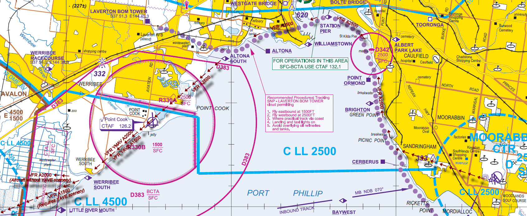
ALBERT PARK LAKE [APL] Overfly - H-308° D-9.4 nm
-
STATION PIER [SNP] Overfly - H-269° D-2.2 nm
-
ALTONA SOUTH [ALTS] Overfly - H-239° D-5.8 nm
-
No scenery for Avalon East - Inbound Avalon rwy 18/36
-
WERRIBEE SOUTH [WBES] Overfly - Visual over land (outbound remain over water) D-8.3 nm
Inbound call to any active Tower or Approach otherwise CTAF -
AVALON [YMAV] Land - Visual
elev : 35
rwy : 18/36 asphalt
CTAF/TWR : 120.10
VOR/DME : AV AVALON 116.10
-
-
With scenery for Avalon East - Inbound Avalon East
-
WERRIBEE SOUTH [WBES] Overfly - Visual over land (outbound remain over water) D-8.3 nm
-
LITTLE RIVER MOUTH [LRM] Overfly - Visual over land (outbound remain over water) D-5.3 nm
Inbound call to any active Tower or Approach otherwise CTAF -
AVALON EAST [YAVE] Land - Visual
elev : 35
rwy : 17L/35R 17R/35L grass
CTAF/TWR : 120.10
-
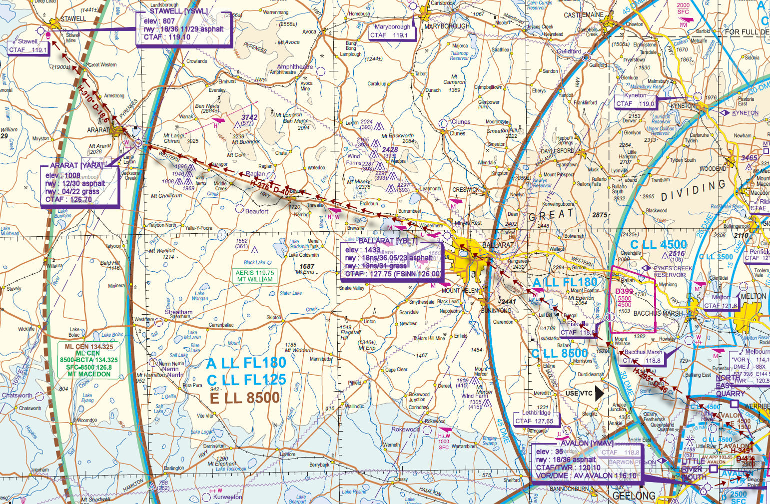
VTC for Moorabbin to Avalon
Leg 2 - Avalon/Avalon East to Stawell
Flightplan
Active GPS flighplan "YMAV_YAVE-YSWL"
With YAVE Scenery - File as : YAVE LRM NEQ YBLT YARA YSWL
Otherwise - File as : YMAV LRM NEQ YBLT YARA YSWL
Flight Details
Use the departure displayed in the chart
-
AVALON [YMAV] / AVALON EAST [YAVE] Takeoff
-
LITTLE RIVER MOUTH [LRM] Overfly - Visual remain over water (inbound over land) D-5.7 nm
-
NORTH EAST QUARRY [NEQ] Overfly - H-349° D-3.9 nm
-
BALLARAT [YBLT] T&G - H-293° D-45.6 nm
elev : 1433
rwy : 18ns/36 05/23 asphalt
rwy : 13ns/31 grass
CTAF : 127.75 (FSINN 126.00) -
ARARAT [YARA] T&G - H-276° D-40.1 nm
elev : 1008
rwy : 12/30 asphalt
rwy : 04/22 grass
CTAF : 126.70 -
STAWELL [YSWL] Land - H-310° D-18.6 nm
elev : 807
rwy : 18/36 11/29 asphalt
CTAF : 119.10
VNC for Avalon to Stawell