Event created by Russell D - 1104622

Event Details
Simulation Date/Time : Current date set to daylight.
Weather : Real World / Fair weather if real world is unsuitable for VFR operations.
Distance : 237 nm
Est Flight Time : approx 80 mins
Aircraft : Single or twin turbine aircraft such as Beechcraft King Air, Pilatus PC-12/PC-9 or similar capable of 180 to 240 kias.
Communications : Australia uses CTAF (Common Traffic Advisory Frequency) for radio comms at uncontrolled airfields. VATSIM pilots connecting to the network using FSCOPILOT/FSINN can install an additional file that provides the ability to tune the CTAF frequency and make voice announcements to other pilots on frequency. These files can be obtained via this link.
For pilots connecting to VATSIM using VPilot, there is a work around that enables these pilots to also take advantage of online voice CTAF. Refer to this informative VATPAC Forum post to learn how to implement the work around. Similarly, this work around has been reported to be successfully adopted for X-Plane using the X-Squawkbox client. As of yet there are no available instructions for doing this.
Altitude : Not above FL125
Flightplan
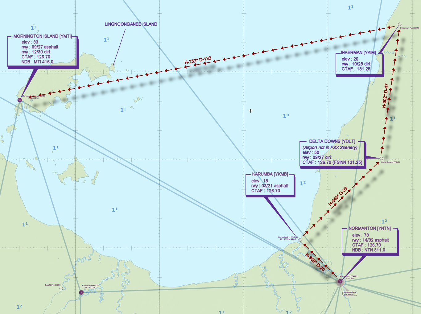
File as : YNTN YKMB YDLT YIKM YMTI
GPS Flightplan is available for FSX and X-Plane FMS and also provided is the original Plan-G flightplan for those that find this useful all enclosed within a Zip archive.
Navigation : Pilots familiar with the area can navigate visually, for those less familiar the accompanying GPS Flightplan is the recommended method of navigating the flight plan.
Navigation : Pilots have a choice of alternatives for this flight. There is the obligatory accompanying flight plan for those that embrace the latest technology. For the more adventurous pilots the radial and distances are provided allowing the flight to be navigated using ground based radio and visual navigation techniques.
Recommended Scenery
Flight Details
-
NORMANTON [YNTN] Takeoff
elev : 73
rwy : 14/32 asphalt
CTAF : 126.70
NDB : NTN NORMANTON 311.0 -
KARUMBA [YKMB] T&G - H-309° D-19.6 nm
elev : 18
rwy : 03/21 asphalt
CTAF : 126.70 -
DELTA DOWNS [YDLT] T&G - H-040° D-38.8 nm
(Airport not in FSX Scenery)
elev : 50
rwy : 09/27 dirt
CTAF : 126.70 (FSINN 131.25) -
INKERMAN [YIKM] T&G - H-002° D-46.9 nm
elev : 20
rwy : 10/28 dirt
CTAF : 131.25 -
MORNINGTON ISLAND [YMTI] Land - H-252° D-131.8 nm
elev : 33
rwy : 09/27 asphalt
rwy : 12/30 dirt
CTAF : 126.70
NDB : MTI 416.0
Chart