Event created by Russell D - 1104622

Event Details
This flight coincides with the final leg Auckland to Brisbane for Cross the Ditch Summer 2018. Pilots can expect heavy levels of Commercial traffic at the destination airport of Brisbane. For those not wishing to incur the likely complications and delays an alternative is to divert to Redcliffe so as to remain outside controlled airspace.
Simulation Date/Time : Current date set to daylight.
Weather : Real World / Fair weather if real world is unsuitable for VFR operations.
Distance : 145 nm
Est Flight Time : approx 75 mins
Aircraft : Single or twin engine aircraft such as Beechcraft Baron, Mooney Bravo or similar capable of 155 to 185 kias.
Communications : Australia uses CTAF (Common Traffic Advisory Frequency) for radio comms at uncontrolled airfields. VATSIM pilots connecting to the network using FSCOPILOT/FSINN can install an additional file that provides the ability to tune the CTAF frequency and make voice announcements to other pilots on frequency. These files can be obtained via this link.
For pilots connecting to VATSIM using VPilot, there is a work around that enables these pilots to also take advantage of online voice CTAF. Refer to this informative VATPAC Forum post to learn how to implement the work around.
Altitude : Not above FL125
Flightplan
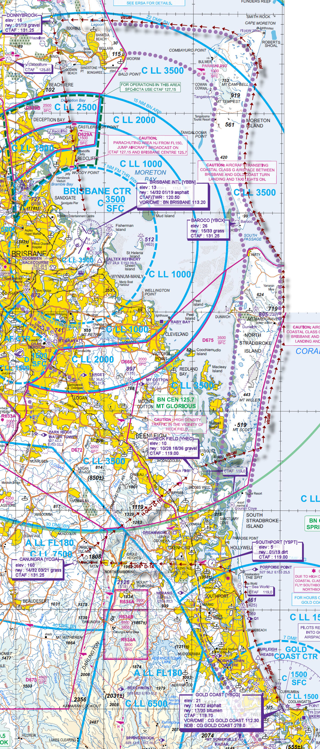
File as : YBCG YSPT YCGA YJCW YBCX DONNYBROOK YBBN
GPS Flightplan is available for FSX and X-Plane FMS and also provided is the original Plan-G flightplan for those that find this useful all enclosed within a Zip archive.
Navigation : Pilots familiar with the area can navigate visually, for those less familiar the accompanying GPS Flightplan is the recommended method of navigating the flight plan.
Recommended Scenery
- ANTS AUSSIE AIRPORTS BRISBANE or ORBX Brisbane International Airport (YBBN) (Payware)
- Gold Coast (YBCG) for FSX (Freeware) or ORBX Gold Coast Airport (YBCG) (Payware)
- ORBX CityScene Gold Coast
- ORBX Australia
- ANTS AUSSIE AIRPORTS
- OZX AU Scenery
Flight Details
-
GOLD COAST [YBCG] Takeoff
elev : 21
rwy : 17/35 asphalt
rwy : 14/32 bitumen
CTAF : 118.70
VOR/DME : CG GOLD COAST 112.30
NDB : CG GOLD COAST 278.0 -
SOUTHPORT [YSPT] T&G - H-323° D-16.5 nm
elev : 5
rwy : 01/19 dirt
CTAF : 119.00 -
CANUNGRA [YCGA] T&G - H-266° D-13.7 nm
elev : 160
rwy : 14/32 03/21 grass
CTAF : 131.25 -
HECK FIELD [YHEC] T&G - H-040° D-15.1 nm
elev : 10
rwy : 10/28 18/36 gravel
CTAF : 119.00 -
BAROCO [YBCX] T&G via Stradbroke VFR Corridor - D-22.0 nm
elev : 26
rwy : 15/33 grass
CTAF : 131.25 -
DONNYBROOK T&G via Stradbroke VFR Corridor - D-6 nm
elev : 16
rwy : 01/19 gravel
CTAF : 131.25 -
BRISBANE INTL [YBBN] Land - H-162° D-22.3 nm
elev : 13
rwy : 14/32 01/19 asphalt
CTAF/TWR : 120.50
VOR/DME : BN BRISBANE 113.20
Chart