Event created by Russell D - 1104622

Event Details
Simulation Date/Time : Current date set to daylight.
Weather : Real World / Fair weather if real world is unsuitable for VFR operations.
Distance : 155 nm
Est Flight Time : approx 80 mins
Aircraft : Single or twin engine aircraft such as Beechcraft Baron, Mooney Bravo or similar capable of 155 to 185 kias.
Communications : Australia uses CTAF (Common Traffic Advisory Frequency) for radio comms at uncontrolled airfields. VATSIM pilots connecting to the network using FSCOPILOT/FSINN can install an additional file that provides the ability to tune the CTAF frequency and make voice announcements to other pilots on frequency. These files can be obtained via this link.
For pilots connecting to VATSIM using VPilot, there is a work around that enables these pilots to also take advantage of online voice CTAF. Refer to this informative VATPAC Forum post to learn how to implement the work around.
Altitude : Not above FL125
Flightplan
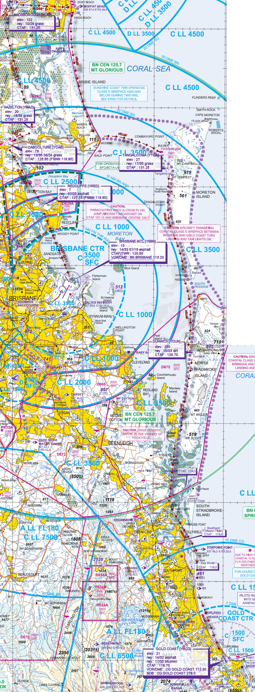
File as : YBBN YRED YCAB YHAZ YLAB EMD MFH WRM YTGA YDUN RUIS Q1 YBCG
GPS Flightplan is available for FSX and X-Plane FMS and also provided is the original Plan-G flightplan for those that find this useful all enclosed within a Zip archive.
Navigation : Pilots familiar with the area can navigate visually, for those less familiar the accompanying GPS Flightplan is the recommended method of navigating the flight plan.
Recommended Scenery
- ANTS AUSSIE AIRPORTS BRISBANE or ORBX Brisbane International Airport (YBBN) (Payware)
- Gold Coast (YBCG) for FSX (Freeware) or ORBX Gold Coast Airport (YBCG) (Payware)
- ORBX CityScene Gold Coast
- ORBX Australia
- ANTS AUSSIE AIRPORTS
- OZX AU Scenery
Flight Details
-
BRISBANE INTL [YBBN] Takeoff
elev : 13
rwy : 14/32 01/19 asphalt
CTAF/TWR : 120.50
VOR/DME : BN BRISBANE 113.20 -
REDCLIFFE [YRED] T&G - H-335° D-11 nm
elev : 7
rwy : 07/25 asphalt
CTAF : 127.15 (FSINN 118.80) -
CABOOLTURE [YCAB] T&G - H-320° D-8.9 nm
elev : 79
rwy : 12/30 06/24 grass
CTAF : 125.85 (FSINN 118.80) -
HAZELTON [YHAZ] T&G - H-052° D-3.9 nm
elev : 20
rwy : 18/36 grass
CTAF : 131.25 -
LANDSBOROUGH [YLAB] T&G - H-333° D-14 nm
elev : 102
rwy : 10/28 grass
CTAF : 131.25 -
EWEN MADDOCK DAM [EMD] Overfly - H-020° D-3.1 nm
-
MOFFAT HEAD [MFH] Overfly - H-088° D-7.3 nm
-
WOORIM [WRM] Overfly - H-157° D-17 nm
-
TANGALOOMA [YTGA] T&G via Stradbroke VFR Corridor - D-10 nm
elev : 27
rwy : 17/35 grass
CTAF : 131.25 -
DUNWICH [YDUN] T&G via Stradbroke VFR Corridor - D-23.2 nm
elev : 250
rwy : 15/33 dirt
CTAF : 126.70 -
RUSSELL ISLAND [RUIS] Overfly via Stradbroke VFR Corridor - D-9.2 nm
-
Q1 [Q1] Overfly - H-161° D-20.6 nm
Inbound reporting point for entry into Gold Coast Airport airspace. -
GOLD COAST [YBCG] Land - H-145° D-10.2 nm
elev : 21
rwy : 14/32 asphalt
rwy : 17/35 bitumen
CTAF : 118.70
VOR/DME : CG GOLD COAST 112.30
NDB : CG GOLD COAST 278.0
Chart