

Event created by Russell D - 1104622

Event Details
As my final official VATPAC VFR Operations event, this flight will begin from Goolwa, a home away from home returning to my home airport of Parafield. Departing Goolwa the flight overflies the series of five barrages that keeps the lower Murray free of salt. The flight continues via Murray Bridge and the Barossa Valley returning to Parafield from the North East.
VFR Coordinator Russell Diehl
Many thanks to pilots, controllers and VATPAC staff for supporting these events these past many years and hope they continue to do so as Dave Bromage takes control and advances these events to even greater altitudes. Expect to see VH-DLL flying these events for many years to come!
Simulation Date/Time : Current date set to daylight.
Weather : Real World / Fair weather if real world is unsuitable for VFR operations.
Distance : 103 nm
Est Flight Time : approx 80 mins
Aircraft : Single piston engine aircraft such as Cessna 172 or similar capable of 105 to 125 kias.
Altitude : Carefully negotiate Adelaide CTA until clear to the south then remain below the steps thereafter.
Flightplan
File as : YGWA YMEG YSYN YMBD WARR DMW YPPF
GPS Flightplan is available for FSX, P3D, FS2020 as a 'pln' file and X-Plane as an 'fms' file. The original Plan-G flightplan is also included for those that find this useful. These are all enclosed within a Zip archive.
Navigation : Pilots familiar with the area can navigate visually, for those less familiar the accompanying GPS Flightplan is the recommended method of navigating the flight.
NOTE : If scenery precludes the jetties along the coastal beaches then consider flying an aircraft that supports the GPS flightplans so the positions of the jetties will be obvious.
Communications
Australia uses CTAF (Common Traffic Advisory Frequency) for radio comms at uncontrolled airfields. Now that VATSIM has introduced AFV (Audio For VATSIM) CTAF can now be used across all VATSIM approved pilot clients. Pilots are requested to tune to the published frequency as detailed in the flight details for an event when operating in or around an aerodome to make and monitor CTAF broadcasts. Pilots should also be aware that it is a VATSIM COC (Code of Conduct) requirement that all pilots at uncontrolled airfields should monitor Unicom (Australia 122.80). It is highly recommended that pilots ensure that at least one of their "on board" COM radios (COM 2 being the most likely) is tuned to receive unicom transmissions in addition to transmitting and receiving on the published CTAF frequency. Please Note. All pilots should also be vigilant regarding the receipt of text on both unicom and CTAF. If it is discovered there is a pilot participating that is unable to receive voice transmissions, pilots should arrange to also broadcast via text to ensure those pilots without the benefit of voice is able to receive appropriate broadcasts. VATSIM provides an update guide for getting AFV working on each of the approved pilot clients.
Pilots also should read this post regarding the implications of using VATSIM UNICOM for CTAF. It provides some insight into potential pitfalls for the unwary when monitoring 122.80 in a CTAF environment.
Recommended Scenery
FSX / P3D
- ORBX Australia
- ANTS AUSSIE AIRPORTS
- OZX 3.5 AU Scenery
- OZX Libraries 1.2 (required for all OZX scenery)
X-Plane 10/11
Parafield Aerodrome
Parafield aerodrome has a layout that can precipitate unintended runway incursions, most prevalently by unwary pilots transiting taxiway B. There are two undershoots to rwys 26L/26R that require clearance to cross. Pilots vacating rwy 03L/21R to B need to be wary returning to the apron when entering these zones. For those that roll through rwy 03L to B5 and vacate, beware as that taxiway is in fact part of the undershoot to rwy 26R.
Air Services Australia offer a handy fact sheet TIPS FOR FLYING AT PARAFIELD and provides valuable insight into operating at Parafield.
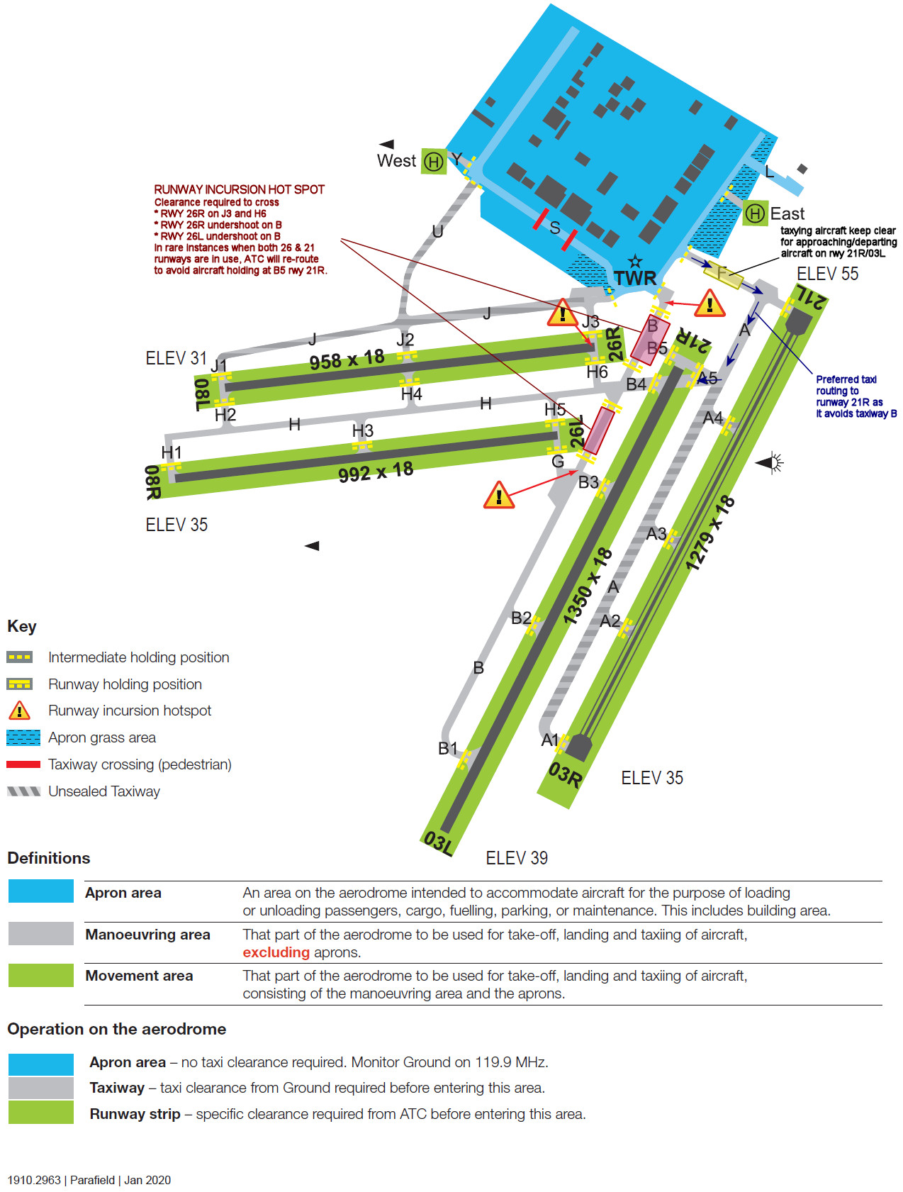
Airport Diagram is extracted from CASA Parafield manoeuvring area map
Circuit Directions
Note : Circuit runways 21L/03R and 26L/08R are only available when ATC is active
Tower Active
- RWY 03L - Left
- RWY 03R - Right
- RWY 21L - Left
- RWY 21R - Right
- RWY 08L - Left
- RWY 08R - Right
- RWY 26L - Left
- RWY 26R - Right
- ATC may at their discretion alter these. Also, when parallel operations are in progress, there may be one tower dedicated to the circuit runway 06R/24L as well as a tower dedicated to the main 03L/21R runway. Check with Parafield ATIS pior to starting.
Tower Inactive
- RWY 03L - Left
- RWY 21R - Right
- RWY 08R - Right
- RWY 26L - Left
- RWY 21L/03R & RWY 26R/08L - Unavailable
Frequencies
- CTAF : 118.70
- TWR : 118.70 / 124.60
- SMC : 119.90
- ATIS : 120.90 / 416
- NDB : PF 416.0
Flight Details
-
GOOLWA [YGWA] Takeoff
elev : 104
rwy : 01/19 gravel
rwy : 16/34 09/27 grass
CTAF : 126.95 -
GOOLWA BARRAGE [GOOLWABG] Overfly - visual D-4
-
MUNDOO BARRAGE [MUNDOO] Overfly - visual D-5
-
BOUNDARY CREEK BARRAGE [BNDRYCK] Overfly - visual D-2
-
EWE ISLAND BARRAGE [EWEISL] Overfly - visual D-1
-
TAUWITCHERE BARRAGE [TAUWICH] Overfly - visual D-3
-
MENINGIE [YMEG] T&G - H-104° D-18
(Scenery not depicted in P3D)
elev : 13
rwy : 14/32 4/22 grass
CTAF : 122.80 -
STRATHALBYN [YSYN] T&G - H-314° D-29
elev : 70
rwy : 14/32 gravel
rwy : 18/36 10/28 grass
CTAF : 122.80 -
MURRAY BRIDGE [YMBD] T&G - H-027° D-19
elev : 180
rwy : 10/28 gravel
rwy : 09/27 grass
CTAF : 127.50 -
WARREN RESERVOIR [WARR] Overfly - H-315° D-26
-
DAM WALL [DMW] Overfly - visual D-10
-
PARAFIELD [YPPF] Land - H-233° D-5
elev : 57
rwy : 08L/26R 08R/26L 03R/21L 03L/21R asphalt
CTAF/TWR : 118.70
NDB : PF PARAFIELD ADELAIDE 416.0
Adelaide Visual Terminal Chart

Adelaide Visual Navigation Chart
