Event created by Russell D - 1104622

Event Details
Simulation Date/Time : Current date set to daylight.
Weather : Real World / Fair weather if real world is unsuitable for VFR operations.
Distance : 170 nm
Est Flight Time : approx 70 mins
Aircraft : Twin or single engine aircraft such as Mooney Bravo, Beechcraft Baron or similar capable of 160 to 190 kias.
Altitude : not above A9500.
Flightplan
File as : YSCR YMVH YWSX YMDN YBRO YQDG YCUN
GPS Flightplan is available for FSX and X-Plane FMS and also provided is the original Plan-G flightplan for those that find this useful all enclosed within a Zip archive.
Navigation : Pilots familiar with the area can navigate visually, for those less familiar the accompanying GPS Flightplan is the recommended method of navigating the flight plan.
Communications
Australia uses CTAF (Common Traffic Advisory Frequency) for radio comms at uncontrolled airfields. Now that VATSIM has introduced AFV (Audio For VATSIM) CTAF can now be used across all VATSIM approved pilot clients. Pilots are requested to tune to the published frequency as detailed in the flight details for an event when operating in or around an aerodome to make and monitor CTAF broadcasts. Pilots should also be aware that it is a VATSIM COC (Code of Conduct) requirement that all pilots at uncontrolled airfields should monitor Unicom (Australia 122.80). It is highly recommended that pilots ensure that at least one of their "on board" COM radios (COM 2 being the most likely) is tuned to receive unicom transmissions in addition to transmitting and receiving on the published CTAF frequency. Please Note. All pilots should also be vigilant regarding the receipt of text on both unicom and CTAF. If it is discovered there is a pilot participating that is unable to receive voice transmissions, pilots should arrange to also broadcast via text to ensure those pilots without the benefit of voice is able to receive appropriate broadcasts. VATSIM provides an update guide for getting AFV working on each of the approved pilot clients.
Recommended Scenery
FSX / P3D
- Alan Blencowe's Complete Scenery Collection
- ORBX Australia
- ANTS AUSSIE AIRPORTS
- OZX 3.5 AU Scenery
- OZX Libraries 1.2 (required for all OZX scenery)
X-Plane 10/11
Flight Details
-
SOUTHERN CROSS [YSCR] Takeoff
elev : 1163
rwy : 09/27 14/32 asphalt
CTAF : 126.70 -
MARVEL LOCH [YMVH] T&G - H-147° D-16
(Scenery not depicted in P3D)
elev : 1429
rwy : 4/22 grass
CTAF : 122.80 -
WESTONIA [YWSX] T&G - H-281° D-44
elev : 1134
rwy : 09/27 01/19 grass
CTAF : 122.80 -
MERREDIN [YMDN] T&G - H-237° D-22
elev : 1263
rwy : 10/28 17/35 asphalt
CTAF : 120.10 -
BRUCE ROCK [YBRO] T&G - H-206° D-24
elev : 947
rwy : 25/07 bitumen
rwy : 18/36 13/31 dirt
CTAF : 122.80 -
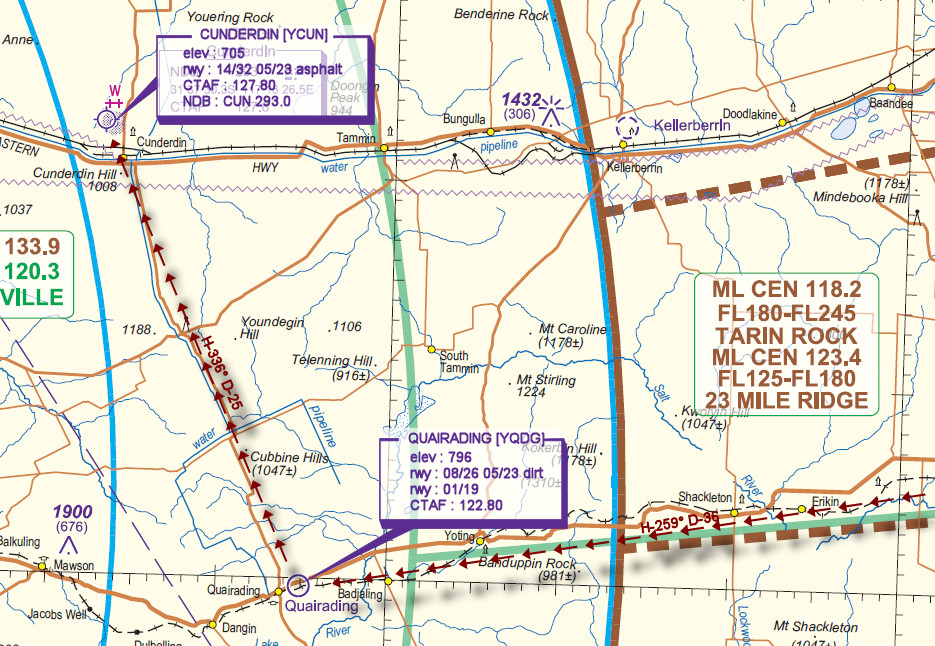
QUAIRADING [YQDG] T&G - H-259° D-36
elev : 796
rwy : 08/26 05/23 dirt
rwy : 01/19
CTAF : 122.80 -
CUNDERDIN [YCUN] Land - H-336° D-25
elev : 705
rwy : 14/32 05/23 asphalt
CTAF : 127.80
NDB : CUN CUNDERDIN 293.0
Wide Area Navigation

Visual Navigation Chart