Event created by Russell D - 1104622

Event Details
Simulation Date/Time : Current date set to daylight.
Weather : Real World / Fair weather if real world is unsuitable for VFR operations.
Distance : 120 nm
Est Flight Time : approx 75 mins
Aircraft : Single engine piston aircraft such as Cessna 172 or similar capable of 105 to 135 kias.
Altitude : Remain clear of Melbourne class C steps.
Flightplan
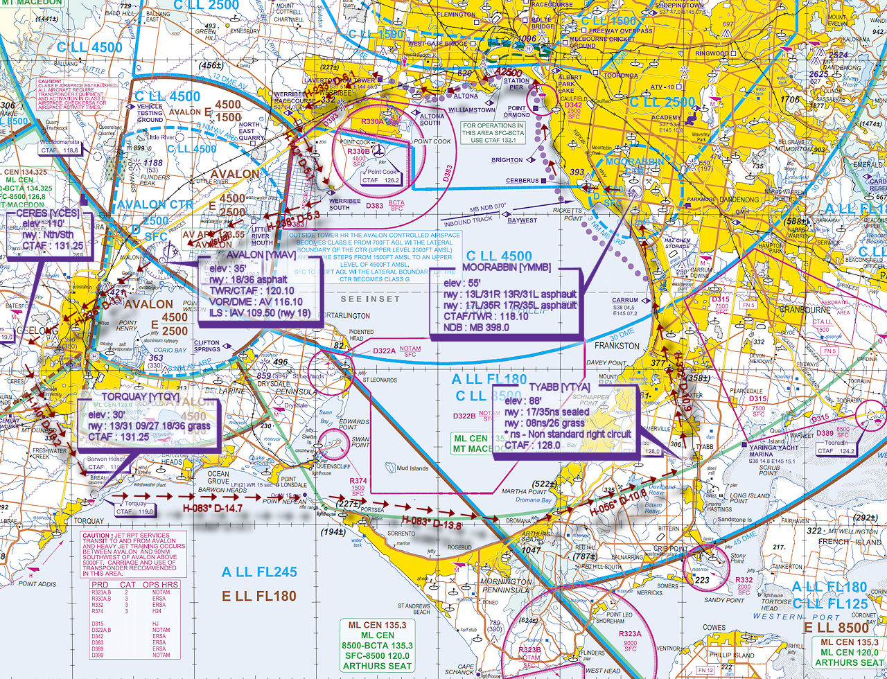
File as : YMMB CERB COASTAL.VFR TON WBER WBES LRM YMAV YCES YTQY YTYA CARR YMMB
GPS Flightplan is available for FSX and X-Plane FMS and also provided is the original Plan-G flightplan for those that find this useful all enclosed within a Zip archive.
Navigation : Pilots familiar with the area can navigate visually, for those less familiar the accompanying GPS Flightplan is the recommended method of navigating the flight plan.
Communications
Australia uses CTAF (Common Traffic Advisory Frequency) for radio comms at uncontrolled airfields. Now that VATSIM has introduced AFV (Audio For VATSIM) CTAF can now be used across all VATSIM approved pilot clients. Pilots are requested to tune to the published frequency as detailed in the flight details for an event when operating in or around an aerodome to make and monitor CTAF broadcasts. Pilots should also be aware that it is a VATSIM COC (Code of Conduct) requirement that all pilots at uncontrolled airfields should monitor Unicom (Australia 122.80). It is highly recommended that pilots ensure that at least one of their "on board" COM radios (COM 2 being the most likely) is tuned to receive unicom transmissions in addition to transmitting and receiving on the published CTAF frequency. Please Note. All pilots should also be vigilant regarding the receipt of text on both unicom and CTAF. If it is discovered there is a pilot participating that is unable to receive voice transmissions, pilots should arrange to also broadcast via text to ensure those pilots without the benefit of voice is able to receive appropriate broadcasts.
VATSIM provides an update guide for getting AFV working on each of the approved pilot clients.
Recommended Scenery
FSX / P3D
- ORBX Australia
- ORBX Moorabbin [YMMB]
- ORBX Avalon [YMAV]
- ANTS AUSSIE AIRPORTS
- OZX 3.5 AU Scenery
- OZX Libraries 1.2 (required for all OZX scenery)
X-Plane 10/11
Moorabbin Procedures
Moorabbin is a general aviation class D aerodrome and is located in close proximity to Melbourne International and Essendon Airport. An excellent source of information for Moorabbin VFR operations inbound and outbound can be found in the OnTrack - Moorabbin VFR Operations video and Air Services Australia Tips for Flying at Moorabbin resource document. Pilots unfamiliar with Moorabbin Operations are encouraged to visit and review available information prior to operating within Moorabbin airspace.
Flight Details
***** For this event UNICOM 122.80 is being redirected to a neutral frequency of 131.25. ****
***** This is only applicable for event traffic to avoid over congestion of UNICOM should there be high levels of traffic. However pilots should continue to monitor UNICOM 122.80 on COM2 *****
-
MOORABBIN [YMMB] Takeoff
elev : 55'
rwy : 13L/31R 13R/31L asphalt
rwy : 17L/35R 17R/35L asphalt
CTAF/TWR : 118.10
NDB : MB 398.0 -
CERBERUS [CERB] Overfly - Visual climb to A2500 to join Melbourne VFR Coastal Route west bound.
-
ALTONA SOUTH [ALTS] Overfly - Visual A2500
-
LAVERTON BOM TOWER [TON] Overfly - Visual A2500
-
WERRIBEE RACE COURSE [WBER] Overfly - H-233° D-6.1 nm
-
WERRIBEE SOUTH [WBES] Overfly - H-142° D-5.1 nm
-
LITTLE RIVER MOUTH [LRM] Overfly - H-238° D-5.3 nm
INBOUND REPORTING POINT FOR AVALON - If Tower is active, obtain ATIS
Call tower "[Callsign][Aircraft Type] AT LITTLE RIVER MOUTH 1500 RECEIVED INFORMATION [Avalon ATIS Identifier] INBOUND
Do not proceed further until tower has issued further join instructions -
AVALON [YMAV] T&G - H-238° D-5.7 nm
elev : 35'
rwy : 18/36 asphalt
TWR/CTAF : 120.10
VOR/DME : AV 116.10
ILS : IAV 109.50 (rwy 18) -
CERES [YCES] T&G - H-226° D-11.7 nm
elev : 110'
rwy : Nth/Sth
CTAF : 131.25 -
TORQUAY [YTQY] T&G - H-140° D-10.2 nm
elev : 30'
rwy : 13/31 09/27 18/36 grass
CTAF : 131.25 -
PT NEPEAN Overfly - H-083° D-14.7 nm
-
DROMANA Overfly - H-083° D-13.8 nm
-
TYABB [YTYA] T&G - H-056° D-10.8 nm
elev : 88'
rwy : 17/35ns sealed
rwy : 08ns/26 grass
* ns - Non standard right circuit
CTAF : 128.0 -
CARRUM [CARR] Overfly A1500 - H-332° D-10.9 nm
Inbound Moorabbin reporting point. Obtain YMMB ATIS if Tower is active.
Inbound Call "MOORABBIN TOWER, [Callsign][Aircraft Type] OVERHEAD CARRUM 1500 RECEIVED INFORMATION [ATIS Identifier] INBOUND
Do not enter the control zone until given further instructions to proceed or join the circuit -
MOORABBIN [YMMB] Land - H-354° D-6.9 nm
Chart