

Russell D - 1104622
-
Posts
602 -
Joined
-
Last visited
-
Days Won
10
Content Type
Profiles
Forums
Calendar
Posts posted by Russell D - 1104622
-
-

Flight detais are being placed here until the VATPAC website has been fully restored.
FLIGHT: Mount Hotham to Merimbula
This week VFR Operations begins from the elevated airport of Mount Hotham and flies to the coastal destination of Merimbula. The scenic tour flies via Orbost, Mallacoota and Gabo Island airports offering pilots opportunities to conduct touch and gos. For this flight, no GPS flightplan will be provided requiring pilots to navigate by other means. Not a hard task given the two prominent VOR's in the area with additional benefit of being able to navigate visually with the aid the coast line.
Event Dates : Friday 11th and Sunday 13th September 2015
Time : 1000z
Simulation Date/Time : Current date set to daylight hours
Weather : Real World / Fair weather if real world is unsuitable for VFR operations.
Scenery : ORBYX (Blue Region),Ozx Australia Complete (Ants Aussie Airports can also be found on the site)
For those looking using FSX and looking for some additional eye candy. John Oien has released enhanced scenery for the following airports (link provided) on this flight.
Distance : approx 180 nm
Aircraft : A single or twin engine aircraft such as Mooney Bravo, Beechcraft Baron 58 or similar capable of 155-180 kias.
Flightplan : YHOT LVG YORB YMCO YGBO YMER
GPS Flightplan : GPS flightplan will not be provided for this flight and pilots are encouraged to fly the route using radio and visual navigation techniques.
Communications : Australia uses CTAF (Common Traffic Advisory Frequency) for radio comms at uncontrolled airfields. VATSIM pilots connecting to the network using FSCOPILOT/FSINN can install an additional file that provides the ability to tune the CTAF frequency and make voice announcements to other pilots on frequency. These files can be obtained via this link.
Details
PILOTS SHOULD ENSURE THEY SET THEIR TRANSPONDER TO MODE "C" (normal) AS THEY ENTER THE RUNWAY SO ATC WILL SEE AIRCRAFT ALTITUDE IN THEIR SCOPE
-
YHOT MOUNT HOTHAM Take Off
elev : 4260'
rwy : 11/29ns asphault
CTAF : 126.75
* ns - non-standard right hand circuits
-
LVG MOUNT LIVINGSTON Overfly - H-106 D-11.8
VOR : LVG 117.20
NDB : LVG 227.0
-
YORB ORBOST T&G - H-116 D-63.7
elev : 94'
rwy : 05/23 dirt/gravel
CTAF : 126.70
-
POINT HICKS Overfly - H-079 D-31.6
-
YMCO MALLACOOTA T&G - H-047 D-24.4
elev : 102'
rwy : 18/36 asphault
rwy : 07/25 gravel
CTAF : 126.70
VOR/DME : MCO 117.50
NDB : MCO 338.0
-
YGBO GABO ISLAND T&G - H-064 D-9.3
elev : 95'
rwy : 07/25 grass
CTAF : 126.70 (use YMCO CTAF)
-
EDEN Overfly - H-346 D-30.0
pos MCO R-001 D-33.0
-
YMER MERIMBULA Land - H-346 D-9.8
elev : 7'
rwy : 03/21 asphault
CTAF : 126.70
DME : MER 117.7
NDB : MER 395.0
Mount Hotham to Merimbula - WAN

-
YHOT MOUNT HOTHAM Take Off
-
Nice roto-craft. Is the Sikorsky 92 as much a handful as the Augusta E101 as found in FSX Acceleration? It certainly has a good cruise speed. I remember you arriving a similar time as the remainder of the fixed wing train.
-
Very sensible choices Aaron. There is a Williamtown enhancement by Lawrence Nichols and some other RAAF airports by another scenery author Robert Graham (Amberly, Edinburgh etc..). The Ants Aussie Airports I mentioned in my previous post also includes Darwin and Tindal. A quick internet search using various parameters should quickly provide some download links for you.
Accu-feel is an environment enhancement. It provides additional sounds and effects adding things like aircraft rattles during taxi, landings and takeoffs, inflight cockpit atmospherics and visual shaking. Whilst I don't have the enhancement, many who have report great satisfaction with how it provides convincing sounds in aged aircraft such as you intend to fly.
Enjoy!
-
G'day Aaron,
Likewise, welcome to VATPAC. I am coordinator for VATPAC - VFR Operations, a weekly event conducted each Friday and Sunday evenings. I might suggest these events are likely to be the type of activity you may want to commence your VATSIM activities. The events are conducted with various forms of GA aircraft through out Australia with occasional ventures to NZ. The events are dispersed and will sometimes be conducted in and out of controlled airspace (requires controller interaction) but more often than not, most of the activities are within non-controlled airspace providing a great deal of freedom to operate at pilot's discretion.
The previous post cites some sound advice in terms of both scenery and aircraft. For VFR OPS, I strongly recommend ORBYX Australian and New Zealand scenery. I also recommend additional scenery from Ozx where a group of enthusiasts have recreated hundreds of Aussie GA and Bush airports all available for free. This would be a first port of call after Orbyx. Whilst there, search out Ants Aussie airports as these are also hosted here. There are also numerous other dedicated authors such as Alan Blencoe who has developed a large assortment of WA airports, Elias Smith who has done similar for both QLD and NSW.
So once you have become familiar with FSX, I recommend using FSINN/FSCOPILOT as the client to connect to VATSIM. When ready to do so I recommend referring to the VATSIM forum where a step by step installation process is provided along with other useful posts regarding the use of this software. The reason I recommend this client is due to it's ability to allow the use of CTAF frequencies commonly used at uncontrolled aerodromes throughout australia for pilots to communicate vocally. Without this, pilots are required to use chat text and there is nothing more frustrating than trying to type messages and hand fly an aircraft at the same time. Take it for me, using text to communicate violates the principles of AVIATE, NAVIGATE then COMMUNICATE. Communicating by text immediately negates a pilot's ability to AVIATE and NAVIGATE.
If you decide that VFR OPS is something you want to participate in, then also consider setting up teamspeak and make your way to VATPAC's server. Most members attending the events can be found there. There is a wealth of advice to be sourced by joining in with these conversations. I hope I am prividged to make your acquaintance in the VATSIM skies. I am usually around somewhere as a pilot. Look for the callsign VH-DLL, or BAW462 along with numerous real world airline callsigns. I am usually flying somewhere in VATSIM.
-
Flight detais are being placed here until the VATPAC website has been fully restored.
FLIGHT: Gibb River to Troughton Island, the Kimberleys
This week VFR Operations visits the Kimberley in the North of Western Australia for a flight from inland Gibb River to the small off shore airport on Troughton Island. The flight visits Drysdale River Station, Mitchell Plateau, Kalumburu and Mungalalu-Truscott airfields for Touch and Go opportunities.
Event Dates : Friday 4th and Sunday 6th August 2015
Time : 1000z
Simulation Date/Time : Current date set to daylight hours
Weather : Real World / Fair weather if real world is unsuitable for VFR operations.
Scenery : ORBYX (Red and Green Region),Ozx Australia Complete (Ants Aussie Airports can also be found on the site)
NOTE : FSX pilots will optionally require additional scenery from WA scenery author Alan Blencoe if they wish to shoot T&G's at Drysdale River Station and Kalumburu. These are available via the following links.
Distance : 205nm
Aircraft : High performance single or twin engine aircraft such as Pilatus PC-12 or similar capable of 180-210 kias.
Flightplan : YGIB YDRD YMIP YKAL YTST YTTI
GPS Flightplan : Download the flightplan here. Hover mouse at top to expose the title bar and click download image/link.
The GPS flightplan provides the most reliable way of navigating the flight, however, those wishing to fly visually can take advantage of provided heading/dist and NDB's to sucessfully navigate the flight.
Communications : Australia uses CTAF (Common Traffic Advisory Frequency) for radio comms at uncontrolled airfields. VATSIM pilots connecting to the network using FSCOPILOT/FSINN can install an additional file that provides the ability to tune the CTAF frequency and make voice announcements to other pilots on frequency. These files can be obtained via this link.
Details
PILOTS SHOULD ENSURE THEY SET THEIR TRANSPONDER TO MODE "C" (normal) AS THEY ENTER THE RUNWAY SO ATC WILL SEE AIRCRAFT ALTITUDE IN THEIR SCOPE
-
YGIB GIBB RIVER Take Off
elev : 1669'
rwy : 07/25 unsealed
CTAF : 128.00
-
YDRD DRYSDALE RIVER + T&G - H-352 D-42.8
elev : 1180'
rwy : 05/23 dirt/gravel
CTAF : 128.00
NDB : 401.0
-
DOONGAN Overfly - H-349 D-20.0
-
YMIP MITCHELL PLATEAU T&G - H-319 D-45.5
elev : 1077'
rwy : 06/24 16/34 unsealed
CTAF : 131.25
-
YKAL KALUMBURU + T&G - H-058 D-56.0
elev : 95'
rwy : 10/28 dirt/gravel
NOTE : Another SW/NE runway is present and has been decommissioned.
CTAF : 128.00
-
YTST TRUSCOTT-MUNGALALU T&G - H-306 D-19.0
elev : 181'
rwy : 12/30 asphault
CTAF : 128.00
NDB : TST 359.0
-
YTTI TROUGHTON ISLAND Land - H-323 D-24.4
elev : 27'
rwy : 14/32 unsealed
CTAF : 128.00
NDB : TTI 413.0
+ - Additional Alan Blencoe scenery required. See scenery section above.
Gibb River to Troughton Island - WAN

-
YGIB GIBB RIVER Take Off
-
Flight detais are being placed here until the VATPAC website has been fully restored.
FLIGHT: Gibb River to Troughton Island, the Northern Kimberleys
This week VFR Operations visits the Kimberley in the North of Western Australia for a flight from inland Gibb River to the small off shore airport on Troughton Island. The flight visits Drysdale River Station, Mitchell Plateau, Kalumburu and Mungalalu-Truscott airfields for Touch and Go opportunities.
Event Dates : Friday 4th and Sunday 6th August 2015
Time : 1000z
Simulation Date/Time : Current date set to daylight hours
Weather : Real World / Fair weather if real world is unsuitable for VFR operations.
Scenery : ORBYX (Red and Green Region),Ozx Australia Complete (Ants Aussie Airports can also be found on the site)
NOTE : FSX pilots will optionally require additional scenery from WA scenery author Alan Blencoe if they wish to shoot T&G's at Drysdale River Station and Kalumburu. These are available via the following links.
Distance : 205nm
Aircraft : High performance single or twin engine aircraft such as Pilatus PC-12 or similar capable of 180-210 kias.
Flightplan : YGIB YDRD YMIP YKAL YTST YTTI
GPS Flightplan : Download the flightplan here. Hover mouse at top to expose the title bar and click download image/link.
The GPS flightplan provides the most reliable way of navigating the flight, however, those wishing to fly visually can take advantage of provided heading/dist and NDB's to sucessfully navigate the flight.
Communications : Australia uses CTAF (Common Traffic Advisory Frequency) for radio comms at uncontrolled airfields. VATSIM pilots connecting to the network using FSCOPILOT/FSINN can install an additional file that provides the ability to tune the CTAF frequency and make voice announcements to other pilots on frequency. These files can be obtained via this link.
Details
PILOTS SHOULD ENSURE THEY SET THEIR TRANSPONDER TO MODE "C" (normal) AS THEY ENTER THE RUNWAY SO ATC WILL SEE AIRCRAFT ALTITUDE IN THEIR SCOPE
-
YGIB GIBB RIVER Take Off
elev : 1669'
rwy : 07/25 unsealed
CTAF : 128.00
-
YDRD DRYSDALE RIVER + T&G - H-352 D-42.8
elev : 1180'
rwy : 05/23 dirt/gravel
CTAF : 128.00
NDB : 401.0
-
DOONGAN Overfly - H-349 D-20.0
-
YMIP MITCHELL PLATEAU T&G - H-319 D-45.5
elev : 1077'
rwy : 06/24 16/34 unsealed
CTAF : 131.25
-
YKAL KALUMBURU + T&G - H-058 D-56.0
elev : 95'
rwy : 10/28 dirt/gravel
NOTE : Another SW/NE runway is present and has been decommissioned.
CTAF : 128.00
-
YTST TRUSCOTT-MUNGALALU T&G - H-306 D-19.0
elev : 181'
rwy : 12/30 asphault
CTAF : 128.00
NDB : TST 359.0
-
YTTI TROUGHTON ISLAND Land - H-323 D-24.4
elev : 27'
rwy : 14/32 unsealed
CTAF : 128.00
NDB : TTI 413.0
+ - Additional Alan Blencoe scenery required. See scenery section above.
Gibb River to Troughton Island - WAN
-
YGIB GIBB RIVER Take Off
-
Flight detais are being placed here until the VATPAC website has been fully restored.
FLIGHT: Singleton to Bankstown via southbound VFR Route - Sunday
This week VFR Operations departs Singleton and flies to Bankstown via the southbound VFR Route from Brooklyn Bridge to Prospect Reservoir then continuing to Bankstown to Land. On the way there are ample opportunities to execute touch and gos at Warkworth, Jerrys Plains (private), Denman (Private), Wiggen, Mangrove Mountain and Somersby.
BANKSTOWN PROCEDURES
Bankstown is a general aviation class D aerodrome and is located in close proximity to Sydney's Charles Kingsford Smith International. An excellent source of information for Bankstown VFR operations inbound and outbound can be found in CASA's "Ontrack" Online Reference Resource. Pilots unfamiliar with Bankstown Operations are encouraged to visit the site and review available information prior to operating within Bankstown airspace.
In particular, review
-
"FIXED WING/BANKSTOWN/INBOUND/INBOUND FROM THE NORTH VIA BROOKLYN BRIDGE".
Event Dates : Sunday 30th August 2015
Time : 1000z
Simulation Date/Time : Current date and daytime
Weather : Real World / Fair weather if real world is unsuitable for VFR operations.
Scenery : ORBYX (Blue Region), Ozx Australia Complete (Ants Aussie Airports can also be found on the site)
Those with FSX will also require additional airport scenery (all airfields except Somersby & Bankstown!) created by Elias Smith obtainable via this link. Installation of all three parts of NSW scenery is recommended, however only these are required for this flight.
- YSGT - Singleton (Departure Airfield)
- YWKW - Warkworth
- YJYP - Jerry's Plains
- YZDM - Denmam (private)
- YZWN - Widden (private)
- YMVM - Mangrove Mountain
Distance : 160nm
Aircraft : Single or twin engine piston aircraft such as Mooney Bravo, Baron 58 or similar capable of 150-175 kias.
Flightplan : YSGT YWKW YSDM YZWN PUTY YMVM YSMB BBG PSP YSBK
GPS Flightplan : Download the flightplan here. Hover mouse at top to expose the title bar and click download image/link.
Take care using the flightplan. Waypoints should be navigated visually to ensure aircraft remain clear of restricted and controlled airspace (CTA). Following the flightplan without deviating may result in RISTRICTED and CTA violations and may also conflict with high terrain.
Details
PILOTS SHOULD ENSURE THEY SET THEIR TRANSPONDER TO MODE "C" (normal) AS THEY ENTER THE RUNWAY SO ATC WILL SEE AIRCRAFT ALTITUDE IN THEIR SCOPE
-
YSGT SINGLETON Take Off
elev : 85'
rwy : 10/28 sealed
CTAF : 126.70
NDB : SGT 290.0
-
YWKW WARKWORTH T&G - H-278 D-9.3
elev : 250'
rwy : 10/28 grass
CTAF : 126.70
-
YJYP JERRYS PLAINS T&G - H-290 D-9.8
elev : 305'
rwy : 11/29 sealed
CTAF : 131.25
-
YDEN DENMAN T&G - H-290 D-9.5
elev : 402'
rwy : 13/31 grass
CTAF : 131.25
-
YWID WIDDEN T&G - H-231 D-19.7
elev : 652'
rwy : 01/19 grass
CTAF : 131.25
-
PUTY Putty Overfly - H-132 D-30.0
-
YMVM MANGROVE MOUNTAIN T&G - H-118 D-33.4
elev : 1027'
rwy : 01/19 unsealed
CTAF : 131.25
-
YSMB SOMERSBY T&G - H-126 D-6.6
elev : 840'
rwy : 04/22 dirt
CTAF : 131.25
-
BGB BROOKLYN BRIDGE Overfly - H-194 D-11.7
Proceed via the SOUTHBOUND VFR ROUTE refer VTC
-
PSP Prospect Reservoir Overfly - via SOUTHBOUND VFR CORRIDOR
If YSBK_TWR active, before reaching PSP tune and note YSBK ATIS identifier 120.90 and set transponder to 3000
CALL YSBK TWR 132.80 to obtain clearance to enter the Bankstown Control Zone.
PROSPECT RESERVOIR A1500
RECEIVED INFORMATION
INBOUND
(DO NOT Proceed beyond PRP until tower has provided instructions to enter the control zone.)
If not controlled make initial CTAF call and proceed.
-
YSBK BANKSTOWN - Land
elev : 37'
rwy : 11L/29R 11C/29C 11R/29L asphault
CTAF/TWR : 132.80
NDB : BK 416.0
Singleton to Bankstown VNC

Sydney VTC

-
"FIXED WING/BANKSTOWN/INBOUND/INBOUND FROM THE NORTH VIA BROOKLYN BRIDGE".
-
Flight detais are being placed here until the VATPAC website has been fully restored.
FLIGHT: Singleton to Bankstown via Richmond GA Route - Friday
This week VFR Operations departs Singleton and flies to Bankstown via the GA Route passing through Richmond restricted airspace then continuing to Bankstown to Land. On the way there are ample opportunities to execute touch and gos at Warkworth, Jerrys Plains(private), Denman (Private), Wiggen and Mangrove Mountain.
BANKSTOWN PROCEDURES
Bankstown is a general aviation class D aerodrome and is located in close proximity to Sydney's Charles Kingsford Smith International. An excellent source of information for Bankstown VFR operations inbound and outbound can be found in CASA's "Ontrack" Online Reference Resource. Pilots unfamiliar with Bankstown Operations are encouraged to visit the site and review available information prior to operating within Bankstown airspace.
In particular, review
-
"FIXED WING/BANKSTOWN/INBOUND/INBOUND FROM THE WEST".
Event Dates : Friday 28th August 2015
Time : 1000z
Simulation Date/Time : Current date and daytime
Weather : Real World / Fair weather if real world is unsuitable for VFR operations.
Scenery : ORBYX (Blue Region), Ozx Australia Complete (Ants Aussie Airports can also be found on the site)
Those with FSX will also require additional airport scenery (all airfields except Bankstown!) created by Elias Smith obtainable via this link. Installation of all three parts of NSW scenery is recommended, however only these are required for this flight.
- YSGT - Singleton (Departure Airfield)
- YWKW - Warkworth
- YJYP - Jerry's Plains
- YZDM - Denmam (private)
- YZWN - Widden (private)
- YMVM - Mangrove Mountain
Distance : 176nm
Aircraft : Single or twin engine piston aircraft such as Mooney Bravo, Baron 58 or similar capable of 150-175 kias.
Flightplan : YSGT YWKW YSDM YZWN PUTY YMVM WSMF RIC-GA-ROUTE NEPN PSP YSBK
GPS Flightplan : Download the flightplan here. Hover mouse at top to expose the title bar and click download image/link.
Take care using the flightplan. Waypoints should be navigated visually to ensure aircraft remain clear of restricted and controlled airspace (CTA). Following the flightplan without deviating may result in RISTRICTED and CTA violations and may also conflict with high terrain.
Details
PILOTS SHOULD ENSURE THEY SET THEIR TRANSPONDER TO MODE "C" (normal) AS THEY ENTER THE RUNWAY SO ATC WILL SEE AIRCRAFT ALTITUDE IN THEIR SCOPE
-
YSGT SINGLETON Take Off
elev : 85'
rwy : 10/28 sealed
CTAF : 126.70
NDB : SGT 290.0
-
YWKW WARKWORTH T&G - H-278 D-9.3
elev : 250'
rwy : 10/28 grass
CTAF : 126.70
-
YJYP JERRYS PLAINS T&G - H-290 D-9.8
elev : 305'
rwy : 11/29 sealed
CTAF : 131.25
-
YDEN DENMAN T&G - H-290 D-9.5
elev : 402'
rwy : 13/31 grass
CTAF : 131.25
-
YWID WIDDEN T&G - H-231 D-19.7
elev : 652'
rwy : 01/19 grass
CTAF : 131.25
-
PUTY Putty Overfly - H-132 D-30.0
-
YMVM MANGROVE MOUNTAIN T&G - H-118 D-33.4
elev : 1027'
rwy : 01/19 unsealed
CTAF : 131.25
-
WSMF Wisemans Ferry Overfly - H-229 D-12.8
CALL RIC TWR 135.50 if active to request transition.
Expect to transit at A1500
WISEMAN'S FERRY
REQUEST TRANSITION RICHMOND VIA GA ROUTE
(expect to provide estimate for reaching KURMOND)
DO NOT PROCEED UNTIL IN RECEIPT OF A CLEARANCE
-
KRMD Kurmond Overfly - H-223 D-17.7
if RIC TWR ACTIVE report overflying with altitude
-
GRRV Grose River Overfly - H-190 D-4.2
-
NEPN Nepean Bridge Overfly - H-168 D-9.1
may be required to report overflying with altitude if RIC TWR ACTIVE
-
PSP Prospect Reservoir Overfly - H-090 D-13.2
If YSBK_TWR active, before reaching PSP tune and note YSBK ATIS identifier 120.90 and set transponder to 3000
CALL YSBK TWR 132.80 to obtain clearance to enter the Bankstown Control Zone.
PROSPECT RESERVOIR A1500
RECEIVED INFORMATION
INBOUND
(DO NOT Proceed beyond PRP until tower has provided instructions to enter the control zone.)
If not controlled make initial CTAF call and proceed.
-
YSBK BANKSTOWN - Land
elev : 37'
rwy : 11L/29R 11C/29C 11R/29L asphault
CTAF/TWR : 132.80
NDB : BK 416.0
Singleton to Bankstown VNC

Sydney VTC

-
"FIXED WING/BANKSTOWN/INBOUND/INBOUND FROM THE WEST".
-
Flight detais are being placed here until the VATPAC website has been fully restored.
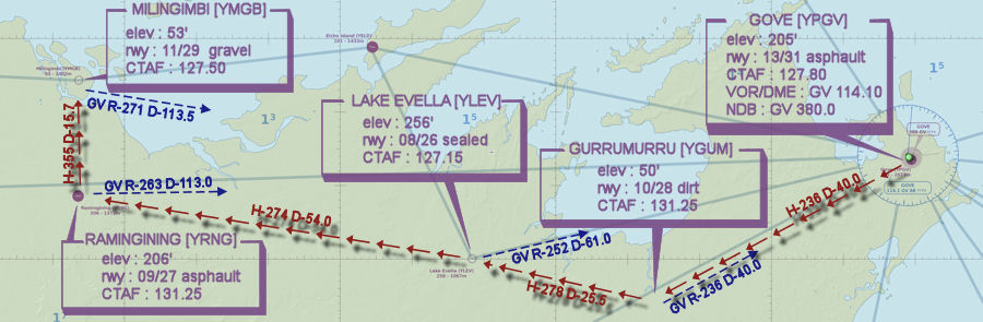
FLIGHT: Gove to Miligimbi via the mainland
This week VFR Operations visits the Northern Territory Coast. This is the reverse of the Friday evening flight taking off from Gove and flying to the island destination of Miligimbi. However, this evening the flight tracks via the slighly shorter mainland route taking in a number of touch and go opportunities at Gurramurra, Lake Evella and Ramingining
Event Date : Sunday 23rd August 2015
Time : 1000z
Simulation Date/Time : Current date set to daylight hours
Weather : Real World / Fair weather if real world is unsuitable for VFR operations.
Scenery : ORBYX (Green Region),Ozx Australia Complete (Ants Aussie Airports can also be found on the site)
Distance : 134nm
Aircraft : Single engine piston aircraft such as Cessna 182 or similar capable of 125-145 kias.
Flightplan : YPGV YGUM YLEV YRNG YMGB
GPS Flightplan : Download the flightplan here. Hover mouse at top to expose the title bar and click download image/link.
The flightplan provides imprecise guidance as the actual flight should track via visual river and road references.
Communications : Australia uses CTAF (Common Traffic Advisory Frequency) for radio comms at uncontrolled airfields. VATSIM pilots connecting to the network using FSCOPILOT/FSINN can install an additional file that provides the ability to tune the CTAF frequency and make voice announcements to other pilots on frequency. These files can be obtained via this link.
Details
PILOTS SHOULD ENSURE THEY SET THEIR TRANSPONDER TO MODE "C" (normal) AS THEY ENTER THE RUNWAY SO ATC WILL SEE AIRCRAFT ALTITUDE IN THEIR SCOPE
-
YPGV GOVE Take Off
elev : 205'
rwy : 13/31 asphault
CTAF : 127.80
VOR/DME : GV 114.10
NDB : GV 380.0
-
YGUM GURRUMURRU T&G - H-236 D-40.0
pos : GV R-236 D-40.0
elev : 50'
rwy : 10/28 dirt
CTAF : 131.25
-
YLEV LAKE EVELLA T&G - H-278 D-25.5
pos : GV R-252 D-61.0
elev : 256'
rwy : 08/26 sealed
CTAF : 127.15
-
YRNG RAMINGINING T&G - H-274 D-54.0
pos : GV R-263 D-113.0
elev : 206'
rwy : 09/27 asphault
CTAF : 131.25
-
YMGB MILINGIMBI Land - H-355 D-15.7
pos : GV R-271 D-113.5
elev : 53'
rwy : 11/29 gravel
CTAF : 127.50
Gove to Miligimbi - WAN
-
YPGV GOVE Take Off
-
Flight detais are being placed here until the VATPAC website has been fully restored.
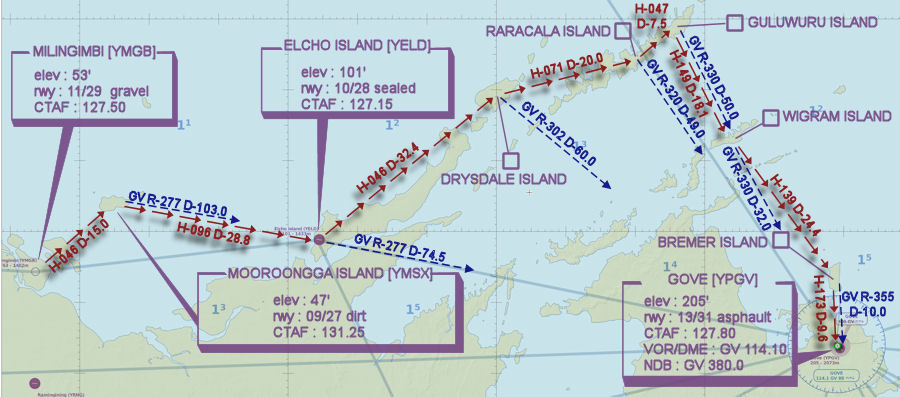
FLIGHT: Miligimbi to Gove - Island Hopping
This week VFR Operations visits the Northern Territory Coast taking off from Milingimbi Island and flying to various islands on the way to mainland Gove at the Eastern side of Arnhem Land. Pilots will have to opportunity to undertake touch and gos at Mooroongga Island and Elcho Island.
Event Dates : Friday 21st August 2015
Time : 1000z
Simulation Date/Time : Current date set to daylight hours
Weather : Real World / Fair weather if real world is unsuitable for VFR operations.
Scenery : ORBYX (Green Region),Ozx Australia Complete (Ants Aussie Airports can also be found on the site)
Distance : 193nm
Aircraft : Single engine piston aircraft such as Cessna 182 or similar capable of 125-145 kias.
Flightplan : YMGB YMSX YELD GULUWURU.ISL YPGV
GPS Flightplan : Download the flightplan here. Hover mouse at top to expose the title bar and click download image/link.
The flightplan provides imprecise guidance as the actual flight should track via visual river and road references.
Communications : Australia uses CTAF (Common Traffic Advisory Frequency) for radio comms at uncontrolled airfields. VATSIM pilots connecting to the network using FSCOPILOT/FSINN can install an additional file that provides the ability to tune the CTAF frequency and make voice announcements to other pilots on frequency. These files can be obtained via this link.
Details
PILOTS SHOULD ENSURE THEY SET THEIR TRANSPONDER TO MODE "C" (normal) AS THEY ENTER THE RUNWAY SO ATC WILL SEE AIRCRAFT ALTITUDE IN THEIR SCOPE
-
YMGB MILINGIMBI Take off
elev : 53'
rwy : 11/29 gravel
CTAF : 127.50
-
YMSX MOOROONGGA ISLAND T&G - H-046 D-15.0
pos : GV R-277 D-103.0
elev : 47'
rwy : 09/27 dirt
CTAF : 131.25
-
YELD ELCHO ISLAND T&G - H-096 D-28.8
pos : GV R-277 D-74.5
elev : 101'
rwy : 10/28 sealed
CTAF : 127.15
-
DRYSDALE ISLAND Overfly - H-046 D-32.4
pos GV R-302 D-60.0
-
RARACALA ISLAND Overfly - H-071 D-20.0
pos GV R-320 D-49
-
GULUWURU ISLAND Overfly - H-047 D-7.5
pos GV R-330 D-50.0
-
WIGRAM ISLAND Overfly - H-149 D-18.1
pos GV R-330 D-32.0
-
BREMER ISLAND Overfly - H-139 D-24.4
pos GV R-355 D-10.0
-
YPGV GOVE Land - H-173 D-9.6
elev : 205'
rwy : 13/31 asphault
CTAF : 127.80
VOR/DME : GV 114.10
NDB : GV 380.0
Miligimbi to Gove - WAN
-
YMGB MILINGIMBI Take off
-
Flight detais are being placed here until the VATPAC website has been fully restored.
FLIGHT: Broken Hill to Mildura via the Great Darling Anabranch
This week VFR Operations reverses Friday's flight from Mildura to Broken Hill but instead returns to Mildura via the Darling River Anabranch. This flight by-passes the touch and go at Pooncarie so is simply a scenic flight from Broken Hill to Mildura.
Event Dates : Sunday 16th August 2015
Time : 1000z
Simulation Date/Time : Current date set to daylight hours
Weather : Real World / Fair weather if real world is unsuitable for VFR operations.
Scenery : ORBYX (Blue and Red Region),Ozx Australia Complete (Ants Aussie Airports can also be found on the site)
Distance : 193nm / approx 100min flight time
Altitude : 1500 - 2500
Aircraft : Twin engine piston aircraft such as Baron 58 or similar capable of 165-185 kias.
Flightplan : YBHI MENINDEE CUTHERO LAKE.POPITAH WENTWORTH YMIA
GPS Flightplan : Download the flightplan here. Hover mouse at top to expose the title bar and click download image/link.
The flightplan provides imprecise guidance as the actual flight should track via visual river and road references.
NOTE : For users of FSX, ORBYX does not depict the Darling and as such pilots will be unable to fly the river visually without assistance of GPS and the provided flight plan. Default FSX scenery provides a more complete depiction of the Darling River and those wishing to fly visually should disable Orbyx and fall back to FSX default.
Communications : Australia uses CTAF (Common Traffic Advisory Frequency) for radio comms at uncontrolled airfields. VATSIM pilots connecting to the network using FSCOPILOT/FSINN can install an additional file that provides the ability to tune the CTAF frequency and make voice announcements to other pilots on frequency. These files can be obtained via this link.
Details
PILOTS SHOULD ENSURE THEY SET THEIR TRANSPONDER TO MODE "C" (normal) AS THEY ENTER THE RUNWAY SO ATC WILL SEE AIRCRAFT ALTITUDE IN THEIR SCOPE
-
YBHI BROKEN HILL LAND - Visual via the Menindee-Broken Hill road
elev : 959'
rwy : 05/23 asphault
rwy : 14/32 brown sand
CTAF : 126.70
VOR/DME : BHI 114.20
NDB : BHI 332.0
-
MENINDEE Overfly - Visual via the main Menindee-Broken Hill road D~60
pos BHI R-109 D-53.3
-
GREAT DARLING ANABRANCH Overfly - Visual via the Darling River D~30
pos BHI R-132 D-68.5
-
REDBANKS CREEK Overfly - Visual via the Darling Anabranch D~10
pos BHI R-154 D-77.5 MIA R-345 D-60.0
-
CUTHERO (Airfield not depicted in FSX scenery) Overfly - Visual via the Darling Anabranch D~10
pos BHI R-149 D-67.5 MIA R-348 D-72.0
-
TRAVELLERS LAKE Overfly - Visual via the Darling Anabranch D~12
pos BHI R-154 D-77.5 MIA R-345 D-60.0
-
POPITAH LAKE Overfly - Visual via the Darling Anabranch D~10
pos BHI R-161 D-72.0 MIA R-337 D-64.4
-
MURRAY-DARLING ANABRANCH Overfly - Visual via the Darling Anabranch D~55
pos MIA R-287 D-17.1
-
WENT WENTWORTH Overfly - Visual via the Murray River D~7
pos MIA R-301 D-11.0
-
YMIA MILDURA Take Off
elev : 167'
rwy : 09/27 18/36 asphault
CTAF : 118.80
VOR/DME : MIA 113.70
NDB : MIA 272.0
Broken Hill to Mildura WAN

-
YBHI BROKEN HILL LAND - Visual via the Menindee-Broken Hill road
-
Flight detais are being placed here until the VATPAC website has been fully restored.
FLIGHT: Mildura to Broken Hill via the Darling River
This week VFR Operations flys from Mildura and flies against the flow from Wentworth where the Darling River flows into the Murray River to Broken Hill. A touch and go is conducted at the intermediate airfield of Pooncarie. Upon reaching the town and lake Menindee the flight departs the Darling River and continues by tracking the main Menindee-Broken Hill road into the mining town of Broken Hill.
Event Dates : Friday 14th August 2015
Time : 1000z
Simulation Date/Time : Current date set to daylight hours
Weather : Real World / Fair weather if real world is unsuitable for VFR operations.
Scenery : ORBYX (Blue and Red Region),Ozx Australia Complete (Ants Aussie Airports can also be found on the site)
NOTE : For users of FSX, ORBYX does not depict the Darling and as such pilots will be unable to fly the river visually without assistance of GPS and the provided flight plan. Default FSX scenery provides a more complete depiction of the Darling River and those wishing to fly visually should disable Orbyx and fall back to FSX default.
Distance : 194nm / approx 100min flight time
Altitude : 1500 - 2500
Aircraft : Twin engine piston aircraft such as Baron 58 or similar capable of 165-185 kias.
Flightplan : YMIA WENTWORTH YPCE MENINDEE YBHI
GPS Flightplan : Download the flightplan here. Hover mouse at top to expose the title bar and click download image/link.
The flightplan provides imprecise guidance as the actual flight should track via river and road visual references.
Communications : Australia uses CTAF (Common Traffic Advisory Frequency) for radio comms at uncontrolled airfields. VATSIM pilots connecting to the network using FSCOPILOT/FSINN can install an additional file that provides the ability to tune the CTAF frequency and make voice announcements to other pilots on frequency. These files can be obtained via this link.
Details
PILOTS SHOULD ENSURE THEY SET THEIR TRANSPONDER TO MODE "C" (normal) AS THEY ENTER THE RUNWAY SO ATC WILL SEE AIRCRAFT ALTITUDE IN THEIR SCOPE
-
YMIA MILDURA Take Off
elev : 167'
rwy : 09/27 18/36 asphault
CTAF : 118.80
VOR/DME : MIA 113.70
NDB : MIA 272.0
-
WENT WENTWORTH Overfly - H-302 D-11.1
pos MIA R-301 D-11.0
-
YPCE POONCARIE T&G - Visual via the Darling River D~62 (note, scenery does not depict this as a continuous river but more as a sequence of river segments)
pos MIA R-017 D-57.2 BHI R-138 D-99.0
There are two significant bends
DARL1 (GPS) as MIA R-345 D-26.0 &
DARL2 (GPS) as MIA R-016 D-36.3
elev : 164'
rwy : 06/24 gravel
CTAF : 126.70
-
LAKE YARTLA Overfly - Visual via the Darling River D~24
pos MIA R-357 D-66.0 BHI R-144 D-77.0
-
GREAT DARLING ANABRANCH Overfly - Visual via the Darling River D~17
pos BHI R-132 D-68.5
-
MENINDEE Overfly - Visual via the Darling River D~30
pos BHI R-109 D-53.3
-
YBHI BROKEN HILL LAND - Visual via the Menindee-Broken Hill road D~60
elev : 959'
rwy : 05/23 asphault
rwy : 14/32 brown sand
CTAF : 126.70
VOR/DME : BHI 114.20
NDB : BHI 332.0
Mildura to Broken Hill WAN

-
YMIA MILDURA Take Off
-
Flight detais are being placed here until the VATPAC website has been fully restored.
FLIGHT: Port Macquarie to Singleton via the "worm"
This week VFR Operations flys from Port Macquarie and flies to Singleton via the "worm", a narrow VFR corridor that allows aircraft to transistion the surrounding restricted Williamtown airspace. Along the way there are ample opportunities for touch and go's at The Lakes, Taree, Maitland, Luskintyre, and Cessnock (Fri) / Elderslie (Sun).
Event Dates : Friday 7th and Sunday 9th August 2015
Time : 1000z
Simulation Date/Time : Current date and daytime
Weather : Real World / Fair weather if real world is unsuitable for VFR operations.
Scenery : ORBYX (Blue and Gold Region), FTX Port Macquarie, Ants Aussie Airports Complete, Ozx Australia Complete (Ants Aussie Airports can also be found on the site)
Those with FSX will also require some additional airport scenery created by Elias Smith obtainable via this link. Installation of all three parts of NSW scenery is recommended, however only these are required for this flight.
- YLKS - The Lakes
- YLSK - Luskintyre
- YSGT - Singleton
- YGCR - Gloucester (optional)
- YDOC - Dochra (singleton army airfield) (optional)
Distance : 145nm
Aircraft : Single engine piston aircraft such as Cessna 172 or similar capable of 105-125 kias.
Flightplan (Fri) : YPMQ YLKS YTRE WDU VFR.LANE EGT YMND YLSK YCNK YSGT
Flightplan (Sun) : YPMQ YLKS YTRE WDU VFR.LANE EGT YMND YLSK YEES YSGT
GPS Flightplan : Download the flightplan here. Hover mouse at top to expose the title bar and click download image/link.
Take care using the flightplan. Waypoints should be navigated visually to ensure aircraft remain clear of restricted airspace and remain within published VFR corridors.
Communications : Australia uses CTAF (Common Traffic Advisory Frequency) for radio comms at uncontrolled airfields. VATSIM pilots connecting to the network using FSCOPILOT/FSINN can install an additional file that provides the ability to tune the CTAF frequency and make voice announcements to other pilots on frequency. These files can be obtained via this link.
Details
PILOTS SHOULD ENSURE THEY SET THEIR TRANSPONDER TO MODE "C" (normal) AS THEY ENTER THE RUNWAY SO ATC WILL SEE AIRCRAFT ALTITUDE IN THEIR SCOPE
NAVIGATION
WILLIAMTOWN
TAC WLM 113.30
NDB WLM 365.0
-
YPMQ PORT MACQUARIE Take Off
elev : 15'
rwy : 03/21 asphault
CTAF : 118.10
NDB : PMQ 395.0
-
YLKS THE LAKES T&G - H-191 D-18.2
elev : 7'
rwy : 16/34 asphault
CTAF : 118.10
-
YTRE TAREE T&G - H-214 D-14.9
elev : 38'
rwy : 04/22 asphault
rwy : 12/30 dirt
CTAF : 118.10
NDB : TRE 371.0
-
WDU WIRRADGURIE Overfly - H-256 D-22.8
VFR Lane Entry - Remain not above A2000
-
GCR GLOUCESTER Overfly - Visual Follow Railway and Highway
Gloucester airfield available for T&G at pilot's discretion
[/indent
-
SRO STROUD ROAD Overfly - Visual Follow Railway and Highway
-
DUNGOG/DINGADEE Overfly - Visual Follow Railway and Highway
WLM D-25.0 - Remain not above A1600
-
EGT EAST GRETA Overfly - Visual - EXIT of VFR LANE
-
YMND MAITLAND (NSW) T&G - H-298 D-3.3
elev : 85'
rwy : 05/23 asphault
rwy : 08/26 sealed
rwy : 18/36 grass/dirt
CTAF : 122.65
VOR : WMD 114.60
NDB : WMD 224.0
-
YLSK LUSKINTYRE T&G - H-347 D-15.0
elev : 118'
rwy : 13/31 grass/clay
CTAF : 131.25
- (Friday)YCNK CESSNOCK T&G - H-195 D-8.3
elev : 210'
rwy : 17/35 sealed
CTAF : 122.65
- (Sunday)YEES ELDERSLIE T&G - H-304 D-5.4
elev : 210'
rwy : 17/35 sealed
CTAF : 122.65
-
YSGT SINGLETON T&G - (Fri) H-298 D-13.4 (Sun) H-256 D-7.4
elev : 85'
rwy : 10/28 grass/clay
CTAF : 126.70
NDB : SGT 290.0
NEWCASTLE VNC (NORTH)

NEWCASTLE VNC (SOUTH)

- YLKS - The Lakes
-
Flight detais are being placed here until the VATPAC website has been fully restored.
FLIGHT: Shark Bay to Carnarvon Western Australia
This week VFR Operations visits Western Australia to circum-navigate Shark Bay over two legs. Friday evening departs Carnarvon and overflies the old NASA tracking site on its way south to Overlander. The flight then turn seaward to join the coast at Hamlin Pools and tracks the penninsula coast stepping into the bay to overfly Faure Island then returning to overfly Monkey Mia to Shark Bay Airport to land.
The Sunday Night leg 2 departs Shark Bay Airport and crosses the bay west to Endless Loop and continues north along the western most penninsula eventually flying over water island hopping Dirk Hartog, Dorre and Bernier Islands then crossing to rejoin the mainland at Quobba Blow Hole and tracks south along the coast returning to Carnarvon to land.
Event Date : Sunday 2nd August 2015
Time : 1000z
Simulation Date/Time : Current date and daytime
Weather : Real World / Fair weather if real world is unsuitable for VFR operations.
Scenery : ORBYX (Blue), Ozx Australia Complete
Distance : 158nm
Aircraft : Single or twin engine piston aircraft such as Mooney Bravo, Beechcraft Baron or similar capable of 125-155 kias.
Flightplan : YSHK ENDLESS.LOOP DIRK.HARTOG.ISL BERNIER.ISL QUOBBA.BLOW.HOLE YCAR
Planned Altitude : A2500
GPS Flightplan : Download the flightplan here. Hover mouse at top to expose the title bar and click download image/link.
Details
-
SHARK BAY AIRPORT [YSHK] T&G - H-232 D-9.7
elev : 111'
rwy : 18/36 bitumen
CTAF : 126.70
-
USELESS LOOP AIRPORT (Not in scenery for FS.) Overfly - H-212 D-18.5
INDENT]pos : CAR R-191 D-77.8
-
DIRK HARTOG ISLAND Overfly - H-320 D-27.6
-
DORRE ISLAND Overfly - H-004 D-40.0
-
BERNIER ISLAND Overfly - H-008 D-17.0
-
QUOBBA BLOW HOLES Overfly - H-034 D-25.7
pos : CAR R-329 D-28.0
-
CARNARVON [YCAR] Land - H-150 D-28.0
elev : 13'
rwy : 04/22 18/36 asphault
CTAF : 126.70
VOR/DME : CAR 113.0
NDB : CAR 323
Shark Bay to Carnarvon WAN

-
SHARK BAY AIRPORT [YSHK] T&G - H-232 D-9.7
-
Flight detais are being placed here until the VATPAC website has been fully restored.
FLIGHT: Carnarvon to Shark Bay Western Australia
This week VFR Operations visits Western Australia to circum-navigate Shark Bay over two legs. Friday evening departs Carnarvon and overflies the old NASA tracking site on its way south to Overlander. The flight then turn seaward to join the coast at Hamlin Pools and tracks the penninsula coast stepping into the bay to overfly Faure Island then returning to overfly Monkey Mia to Shark Bay Airport to land.
The Sunday Night leg 2 departs Shark Bay Airport and crosses the bay west to Endless Loop and continues north along the western most penninsula eventually flying over water island hopping Dirk Hartog, Dorre and Bernier Islands then crossing to rejoin the mainland at Quobba Blow Hole and tracks south along the coast returning to Carnarvon to land.
Event Date : Friday 31st July 2015
Time : 1000z
Simulation Date/Time : Current date and daytime
Weather : Real World / Fair weather if real world is unsuitable for VFR operations.
Scenery : ORBYX (Blue), Ozx Australia Complete
Distance : 175nm
Aircraft : Single or twin engine piston aircraft such as Mooney Bravo, Beechcraft Baron or similar capable of 125-155 kias.
Flightplan : YCAR OVL YSHK
Planned Altitude : A2500
GPS Flightplan : Download the flightplan here. Hover mouse at top to expose the title bar and click download image/link.
Details
-
CARNARVON [YCAR] - Take off departure East
elev : 13'
rwy : 04/22 18/36 asphault
CTAF : 126.70
-
OTC Telecommunications Antennas Overfly - H-069 D-2.3
-
OLD NASA TRACKING SITE/RADIO AUSTRALIA Overfly - H-314 D-4.5
-
WOORAMEL RIVER Overfly - H-150 D-59.5
pos : CAR R-148 D-62.0
-
OVERLANDER [OVL] Overfly - H-165 D-40.0
pos : CAR R-155 D-100.0
-
HAMELIN POOLS Overfly - H-263 D-14.8
pos : CAR R-163 D-97.0
-
FAURE ISLAND Overfly - H-335 D-38.3
-
MONKEY MIA Overfly - H-291 D-10.0
pos : CAR R-178 D-55.0
-
SHARK BAY AIRPORT [YSHK] T&G - H-232 D-9.7
pos : CAR R-185 D-61.0
elev : 111'
rwy : 18/36 bitumen
CTAF : 126.70
Carnarvon to Shark Bay WAN

-
CARNARVON [YCAR] - Take off departure East
-
Flight detais are being placed here until the VATPAC website has been fully restored.
FLIGHT: Shark Bay to Carnarvon Western Australia
This week VFR Operations visits Western Australia to circum-navigate Shark Bay over two legs. Friday evening departs Carnarvon and overflies the old NASA tracking site on its way south to Overlander. The flight then turn seaward to join the coast at Hamlin Pools and tracks the penninsula coast stepping into the bay to overfly Faure Island then returning to overfly Monkey Mia to Shark Bay Airport to land.
The Sunday Night leg 2 departs Shark Bay Airport and crosses the bay west to Endless Loop and continues north along the western most penninsula eventually flying over water island hopping Dirk Hartog, Dorre and Bernier Islands then crossing to rejoin the mainland at Quobba Blow Hole and tracks south along the coast returning to Carnarvon to land.
Event Date : Sunday 2nd August 2015
Time : 1000z
Simulation Date/Time : Current date and daytime
Weather : Real World / Fair weather if real world is unsuitable for VFR operations.
Scenery : ORBYX (Blue), Ozx Australia Complete
Distance : 158nm
Aircraft : Single or twin engine piston aircraft such as Mooney Bravo, Beechcraft Baron or similar capable of 125-155 kias.
Flightplan : YSHK ENDLESS.LOOP DIRK.HARTOG.ISL BERNIER.ISL QUOBBA.BLOW.HOLE YCAR
Planned Altitude : A2500
GPS Flightplan : Download the flightplan here. Hover mouse at top to expose the title bar and click download image/link.
Details
-
SHARK BAY AIRPORT [YSHK] T&G - H-232 D-9.7
elev : 111'
rwy : 18/36 bitumen
CTAF : 126.70
-
USELESS LOOP AIRPORT (Not in scenery for FS.) Overfly - H-212 D-18.5
INDENT]pos : CAR R-191 D-77.8
-
DIRK HARTOG ISLAND Overfly - H-320 D-27.6
-
DORRE ISLAND Overfly - H-004 D-40.0
-
BERNIER ISLAND Overfly - H-008 D-17.0
-
QUOBBA BLOW HOLES Overfly - H-034 D-25.7
pos : CAR R-329 D-28.0
-
CARNARVON [YCAR] Land - H-150 D-28.0
elev : 13'
rwy : 04/22 18/36 asphault
CTAF : 126.70
VOR/DME : CAR 113.0
NDB : CAR 323
Shark Bay to Carnarvon WAN
-
SHARK BAY AIRPORT [YSHK] T&G - H-232 D-9.7
-
Flight detais are being placed here until the VATPAC website has been fully restored.
FLIGHT: Carnarvon to Shark Bay - Western Australia
This week VFR Operations visits Western Australia to circum-navigate Shark Bay over two legs. Friday evening departs Carnarvon and overflies the old NASA tracking site on its way south to Overlander. The flight then turn seaward to join the coast at Hamlin Pools and tracks the penninsula coast stepping into the bay to overfly Faure Island then returning to overfly Monkey Mia to Shark Bay Airport to land.
The Sunday Night leg 2 departs Shark Bay Airport and crosses the bay west to Endless Loop and continues north along the western most penninsula eventually flying over water island hopping Dirk Hartog, Dorre and Bernier Islands then crossing to rejoin the mainland at Quobba Blow Hole and tracks south along the coast returning to Carnarvon to land.
Event Date : Friday 31st July 2015
Time : 1000z
Simulation Date/Time : Current date and daytime
Weather : Real World / Fair weather if real world is unsuitable for VFR operations.
Scenery : ORBYX (Blue), Ozx Australia Complete
Distance : 175nm
Aircraft : Single or twin engine piston aircraft such as Mooney Bravo, Beechcraft Baron or similar capable of 125-155 kias.
Flightplan : YCAR OVL YSHK
Planned Altitude : A2500
GPS Flightplan : Download the flightplan here. Hover mouse at top to expose the title bar and click download image/link.
Details
-
CARNARVON [YCAR] - Take off departure East
elev : 13'
rwy : 04/22 18/36 asphault
CTAF : 126.70
-
OTC Telecommunications Antennas Overfly - H-069 D-2.3
-
OLD NASA TRACKING SITE/RADIO AUSTRALIA Overfly - H-314 D-4.5
-
WOORAMEL RIVER Overfly - H-150 D-59.5
pos : CAR R-148 D-62.0
-
OVERLANDER [OVL] Overfly - H-165 D-40.0
pos : CAR R-155 D-100.0
-
HAMELIN POOLS Overfly - H-263 D-14.8
pos : CAR R-163 D-97.0
-
FAURE ISLAND Overfly - H-335 D-38.3
-
MONKEY MIA Overfly - H-291 D-10.0
pos : CAR R-178 D-55.0
-
SHARK BAY AIRPORT [YSHK] T&G - H-232 D-9.7
pos : CAR R-185 D-61.0
elev : 111'
rwy : 18/36 bitumen
CTAF : 126.70
Carnarvon to Shark Bay WAN
-
CARNARVON [YCAR] - Take off departure East
-
G'day.
Have noticed recently that the paging and search functions in the various VATPAC Data and Activity Pages are non-functional. Is anyone else aware of this?
-
Flight detais are being placed here until the VATPAC website has been fully restored.
FLIGHT: Lake Pedder Hobart - Derwent River/Cambridge
This week VFR Operations visits Tasmania for a weekend away from the rat race. Friday's flight departed Cambridge/Hobart to the south west visiting Bruny Island then rejoins the main land and then flies to Lake Pedder taking in some of the higher peaks along the track. Tonight's flight returns to Hobart flying amphibious/water aircraft to Derwent River Hobart visiting lakes and dams on the way. Pilots without access to amphibious aircraft can also fly an alternative route to encompass some airfields and land via Cambridge.
CAMBRIDGE PROCEDURES
Pilots of amphibious aircraft will not have to concern themselves with Cambridge procedures, however will need to be aware of those that are. They will however have to remain clear of Class C airspace. For pilots of land based aircraft, Cambridge is a class D aerodrome co-located with Hobart class C. An excellent source of information for Cambridge VFR operations inbound and outbound can be found in CASA's "Ontrack" Online Reference Resource. Pilots unfamiliar with Cambridge Operations are encouraged to visit the site and review available information prior to operating within Cambridge and Hobart.
In particular, review
-
"FIXED WING/CAMBRIDGE/INBOUND/INBOUND FROM THE N-W VIA MANGALORE".
Details for Cambridge
CAMBRIDGE / HOBART [YCBG] - Take off departure South West
elev : 67'
rwy : 12/30 (aligns with YMHB) 09/27 14/32 asphault
CTAF / HB_TWR : 118.10
Event Dates : Sunday 26th July 2015
Time : 1000z
Simulation Date/Time : Current date and daytime
Weather : Real World / Fair weather if real world is unsuitable for VFR operations.
Scenery : ORBYX (Blue), Ozx Australia Complete
Distance : 139nm
Aircraft : Single or twin engine piston amphibious aircraft such as Maul, Cessna Caravan, Twin Otter or similar capable of 115-145 kias and equipped with floats. Land based aircraft are also welcome.
Flightplan : [Amphibious] YLPR REPULSE LKEC LK.CRESCENT LK.DULVER LK.TIBER CBV MGL ZMHB
Planned Altitude : A4500
GPS Flightplan : Download the flightplan here. Hover mouse at top to expose the title bar and click download image/link.
NOTE : GPS is specific to the Amphibious flight and does not provide navigation for the airfields
Details
PILOTS SHOULD ENSURE THEY SET THEIR TRANSPONDER TO MODE "C" (normal) AS THEY ENTER THE RUNWAY SO ATC WILL SEE AIRCRAFT ALTITUDE IN THEIR SCOPE
-
LAKE PEDDER [YLPR][/url] Land - H-285 D-11.5
elev : 1026'
rwy : 06/24 gravel
water rwy : available in the adjacent Lake Gordon to the NE
CTAF : 131.25
-
REPULSE POWER STATION / DERWENT RIVER Splash & Go - H-057 D-28.4
-
LAKE ECHO [LKEC] Splash & Go - H-345 D-20.4
ALTERNATE - Wadamana [YWDM] / 2190' / rwy 03/21 / CTAF 131.25
-
LAKE CRESCENT Splash & Go - H-092 D-24.1
ALTERNATE - Interlaken / 2690' / rwy 08/26 / CTAF 131.25
-
LAKE DULVERTON Splash & Go - H-116 D-11.7
ALTERNATE - Woodbury Gliding [YWOD]/ 709' / rwy 01/19 14/32 grass / CTAF 131.25
-
LAKE TIBERIAS Splash & Go - H-171 D-7.2
ALTERNATE - Jericho [YJCO]/ 1389' / rwy 01/19 grass / CTAF 131.25
-
CRAIGBOURNE RESV[CBV] Splash & Go - H-148 D-7.9
-
MANGALORE Overfly not above 3500 - H-230 D-10.1
Inbound call for pilots landing YCBG. CTAF/TWR 118.10
Aircraft for the DERWENT RIVER track south descending below 2500 by HB 16 DME then follow the river. Remain WEST of the Eastern Shore to Remain OCTA
-
HOBART / DERWENT RIVER Water Landing - H-180 until Visual with the Derwent River
ALTERNATE - Cambridge [YCBG]
Lake Pedder to Hobart / Derwent River WAN

Hobart VTC

-
"FIXED WING/CAMBRIDGE/INBOUND/INBOUND FROM THE N-W VIA MANGALORE".
-
Flight detais are being placed here until the VATPAC website has been fully restored.
FLIGHT: Cambridge to Lake Pedder
This week VFR Operations visits Tasmania for a weekend away from the rat race. Friday's flight departs Cambridge/Hobart to the south west visiting Bruny Island then rejoins the main land and then flies to Lake Pedder taking in some of the higher peaks along the track. Sunday's flight returns to Hobart flying amphibious/water aircraft to Derwent River Hobart visiting lakes and dams on the way.
CAMBRIDGE PROCEDURES
Cambridge a class D aerodrome co-located with Habart class C. An excellent source of information for Cambridge VFR operations inbound and outbound can be found in CASA's "Ontrack" Online Reference Resource. Pilots unfamiliar with Cambridge Operations are encouraged to visit the site and review available information prior to operating within Cambridge and Hobart.
In particular, review
-
"FIXED WING/CAMBRIDGE/OUTBOUND/OUTBOUND TO THE SOUTH-WEST".
Event Dates : Friday 24th July 2015
Time : 1000z
Simulation Date/Time : Current date and daytime
Weather : Real World / Fair weather if real world is unsuitable for VFR operations.
Scenery : ORBYX (Blue), Ozx Australia Complete
Distance : 139nm
Aircraft : Single or twin engine piston aircraft such as Maul, Cessna Caravan, Twin Otter or similar capable of 115-145 kias. Also handy if the type is available with floats for the return trip on Sunday.
Flightplan : YCBG TAS YBYI YBHB FDP YLPR
Planned Altitude : A4500
GPS Flightplan : Download the flightplan here. Hover mouse at top to expose the title bar and click download image/link.
Details
PILOTS SHOULD ENSURE THEY SET THEIR TRANSPONDER TO MODE "C" (normal) AS THEY ENTER THE RUNWAY SO ATC WILL SEE AIRCRAFT ALTITUDE IN THEIR SCOPE
-
CAMBRIDGE / HOBART [YCBG] - Take off departure South West
elev : 67'
rwy : 12/30 (aligns with YMHB) 09/27 14/32 asphault
CTAF / HB_TWR : 118.10
-
TASMAN BRIDGE [TAS] Overfly - H-314 D-4.5
continue with the South-West Departure to WREST POINT CASINO and continue coastal to Bruny Island
-
BRUNY ISLAND [YBYI] T&G - H-176 D-22.3
elev : 50'
rwy : 13/31 dirt
CTAF : 131.25
-
ADVENTURE BAY Overfly - H-183 D-8.2
-
SOUTHPORT Overfly - H-241 D-16.0
-
BATHURST HARBOUR [YBYI] T&G - H-256 D-35.2
elev : 14'
rwy : 12/30 dirt
CTAF : 131.25
-
FEDERATION PEAK [FDP] Overfly - H-039 D-15.6
-
MOUNT WELD Overfly - H-020 D-16.7
-
MOUNT ANNE Overfly - H-284 D-7.7
-
LAKE PEDDER [YLPR] Land - H-285 D-11.5
elev : 1026'
rwy : 06/24 gravel
water rwy : available in the adjacent Lake Gordon to the NE
CTAF : 131.25
Cambridge VTC

Cambridge to Lake Pedder WAN

-
"FIXED WING/CAMBRIDGE/OUTBOUND/OUTBOUND TO THE SOUTH-WEST".
-
Flight detais are being placed here until the VATPAC website has been fully restored.
FLIGHT: Lake Pedder Hobart - Derwent River/Cambridge
This week VFR Operations visits Tasmania for a weekend away from the rat race. Friday's flight departed Cambridge/Hobart to the south west visiting Bruny Island then rejoins the main land and then flies to Lake Pedder taking in some of the higher peaks along the track. Tonight's flight returns to Hobart flying amphibious/water aircraft to Derwent River Hobart visiting lakes and dams on the way. Pilots without access to amphibious aircraft can also fly an alternative route to encompass some airfields and land via Cambridge.
CAMBRIDGE PROCEDURES
Pilots of amphibious aircraft will not have to concern themselves with Cambridge procedures, however will need to be aware of those that are. They will however have to remain clear of Class C airspace. For pilots of land based aircraft, Cambridge is a class D aerodrome co-located with Hobart class C. An excellent source of information for Cambridge VFR operations inbound and outbound can be found in CASA's "Ontrack" Online Reference Resource. Pilots unfamiliar with Cambridge Operations are encouraged to visit the site and review available information prior to operating within Cambridge and Hobart.
In particular, review
-
"FIXED WING/CAMBRIDGE/INBOUND/INBOUND FROM THE N-W VIA MANGALORE".
Details for Cambridge
CAMBRIDGE / HOBART [YCBG] - Take off departure South West
elev : 67'
rwy : 12/30 (aligns with YMHB) 09/27 14/32 asphault
CTAF / HB_TWR : 118.10
Event Dates : Sunday 26th July 2015
Time : 1000z
Simulation Date/Time : Current date and daytime
Weather : Real World / Fair weather if real world is unsuitable for VFR operations.
Scenery : ORBYX (Blue), Ozx Australia Complete
Distance : 139nm
Aircraft : Single or twin engine piston amphibious aircraft such as Maul, Cessna Caravan, Twin Otter or similar capable of 115-145 kias and equipped with floats. Land based aircraft are also welcome.
Flightplan : [Amphibious] YLPR REPULSE LKEC LK.CRESCENT LK.DULVER LK.TIBER CBV MGL ZMHB
Planned Altitude : A4500
GPS Flightplan : Download the flightplan here. Hover mouse at top to expose the title bar and click download image/link.
NOTE : GPS is specific to the Amphibious flight and does not provide navigation for the airfields
Details
PILOTS SHOULD ENSURE THEY SET THEIR TRANSPONDER TO MODE "C" (normal) AS THEY ENTER THE RUNWAY SO ATC WILL SEE AIRCRAFT ALTITUDE IN THEIR SCOPE
-
LAKE PEDDER [YLPR][/url] Land - H-285 D-11.5
elev : 1026'
rwy : 06/24 gravel
water rwy : available in the adjacent Lake Gordon to the NE
CTAF : 131.25
-
REPULSE POWER STATION / DERWENT RIVER Splash & Go - H-057 D-28.4
-
LAKE ECHO [LKEC] Splash & Go - H-345 D-20.4
ALT - Wadamana [YWDM] / 2190' / rwy 03/21 / CTAF 131.25
-
LAKE CRESCENT Splash & Go - H-092 D-24.1
ALTERNATE - Interlaken / 2690' / rwy 08/26 / CTAF 131.25
-
LAKE DULVERTON Splash & Go - H-116 D-11.7
ALTERNATE - Woodbury Gliding [YWOD]/ 709' / rwy 01/19 14/32 grass / CTAF 131.25
-
LAKE TIBERIAS Splash & Go - H-171 D-7.2
ALTERNATE - Jericho [YJCO]/ 1389' / rwy 01/19 grass / CTAF 131.25
-
CRAIGBOURNE RESV[CBV] Splash & Go - H-148 D-7.9
-
MANGALORE Overfly not above 3500 - H-230 D-10.1
Inbound call for pilots landing YCBG. CTAF/TWR 118.10
Aircraft for the DERWENT RIVER track south descending below 2500 by HB 16 DME then follow the river. Remain WEST of the Eastern Shore to Remain OCTA
-
HOBART / DERWENT RIVER Water Landing - H-180 until Visual with the Derwent River
ALTERNATE - Cambridge [YCBG]
Lake Pedder to Hobart / Derwent River WAN
Hobart VTC
-
"FIXED WING/CAMBRIDGE/INBOUND/INBOUND FROM THE N-W VIA MANGALORE".
-
Flight detais are being placed here until the VATPAC website has been fully restored.
FLIGHT: Cambridge to Lake Pedder
This week VFR Operations visits Tasmania for a weekend away from the rat race. Friday's flight departs Cambridge/Hobart to the south west visiting Bruny Island then rejoins the main land and then flies to Lake Pedder taking in some of the higher peaks along the track. Sunday's flight returns to Hobart flying amphibious/water aircraft to Derwent River Hobart visiting lakes and dams on the way.
CAMBRIDGE PROCEDURES
Cambridge a class D aerodrome co-located with Habart class C. An excellent source of information for Cambridge VFR operations inbound and outbound can be found in CASA's "Ontrack" Online Reference Resource. Pilots unfamiliar with Cambridge Operations are encouraged to visit the site and review available information prior to operating within Cambridge and Hobart.
In particular, review
-
"FIXED WING/CAMBRIDGE/OUTBOUND/OUTBOUND TO THE SOUTH-WEST".
Event Dates : Friday 24th July 2015
Time : 1000z
Simulation Date/Time : Current date and daytime
Weather : Real World / Fair weather if real world is unsuitable for VFR operations.
Scenery : ORBYX (Blue), Ozx Australia Complete
Distance : 139nm
Aircraft : Single or twin engine piston aircraft such as Maul, Cessna Caravan, Twin Otter or similar capable of 115-145 kias. Also handy if the type is available with floats for the return trip on Sunday.
Flightplan : YCBG TAS YBYI YBHB FDP YLPR
Planned Altitude : A4500
GPS Flightplan : Download the flightplan here. Hover mouse at top to expose the title bar and click download image/link.
Details
PILOTS SHOULD ENSURE THEY SET THEIR TRANSPONDER TO MODE "C" (normal) AS THEY ENTER THE RUNWAY SO ATC WILL SEE AIRCRAFT ALTITUDE IN THEIR SCOPE
-
CAMBRIDGE / HOBART [YCBG] - Take off departure South West
elev : 67'
rwy : 12/30 (aligns with YMHB) 09/27 14/32 asphault
CTAF / HB_TWR : 118.10
-
TASMAN BRIDGE [TAS] Overfly - H-314 D-4.5
continue with the South-West Departure to WREST POINT CASINO and continue coastal to Bruny Island
-
BRUNY ISLAND [YBYI] T&G - H-176 D-22.3
elev : 50'
rwy : 13/31 dirt
CTAF : 131.25
-
ADVENTURE BAY Overfly - H-183 D-8.2
-
SOUTHPORT Overfly - H-241 D-16.0
-
BATHURST HARBOUR [YBYI] T&G - H-176 D-22.3
elev : 14'
rwy : 12/30 dirt
CTAF : 131.25
-
FEDERATION PEAK [FDP] Overfly - H-039 D-15.6
-
MOUNT WELD Overfly - H-020 D-16.7
-
MOUNT ANNE Overfly - H-284 D-7.7
-
LAKE PEDDER [YLPR] Land - H-285 D-11.5
elev : 1026'
rwy : 06/24 gravel
water rwy : available in the adjacent Lake Gordon to the NE
CTAF : 131.25
Cambridge VTC
Cambridge to Lake Pedder WAN

-
"FIXED WING/CAMBRIDGE/OUTBOUND/OUTBOUND TO THE SOUTH-WEST".
-
Flight detais are being placed here until the VATPAC website has been fully restored.
FLIGHT: New Zealand's Chatham Island
This week VFR Operations flys at New Zealand's eastern most point of Chatham Islands. The flight takes off and lands at the sole airport on the island and tours the island and surrounding islands.
This flight coincides with VATNZ Chatham Island Sunday Night Ops on Sunday 19th July and pilots are encouraged to participate in the event and fly out to the island prior to embarking on the VFR tour.
Event Dates : Friday 17th and 19th July 2015
Time : 1000z
Simulation Date/Time : Current date and daytime
Weather : Real World / Fair weather if real world is unsuitable for VFR operations.
Scenery : ORBYX NZ South Island (preferred) or alternatively Chatham Islands Free Scenery by Carlyle Sharpe downloadable here. Unzip the enclosed folder and add it to FSX scenery as per usual. (Note : the scenery includes terrain mesh for New Zealand.)
Distance : 160nm
Aircraft : Single or twin engine piston aircraft such as Cessna Caravan, Baron 58, Dash 6 Twin Otter or similar capable of 135-175 kias.
Flightplan : NZCI SISTERS CI THE.PYRAMID PITT.ISLAND FORTY.FOUR NZCI
GPS Flightplan : Download the flightplan here. Hover mouse at top to expose the title bar and click download image/link.
Details
PILOTS SHOULD ENSURE THEY SET THEIR TRANSPONDER TO MODE "C" (normal) AS THEY ENTER THE RUNWAY SO ATC WILL SEE AIRCRAFT ALTITUDE IN THEIR SCOPE
-
CHATHAM ISLANAD/TUUTA [NZCI] - Take off
elev : 43'
rwy : 05/23 asphault
CTAF : 122.80
-
Lake Wharo [LWHA] Overfly - H-314 D-4.5
-
Puhina Overfly - H-273 D-6.0
-
The Sisters [sISTERS] Overfly - H-292 D-11.1
-
Te Puke Hill [TPH] Overfly - H-150 D-13.0
-
Port Hutt [PTHUTT] Overfly - H-099 D-3.4
-
Chatham Islands VOR 116.2 [CI] Overfly - H-121 D-10.8
-
Stony Hill [sTONY] Overfly - H-206 D-6.1
-
Mangere Island [MGISL] Overfly - H-108 D-22.3
-
Munamuru [MUNURU] Overfly - H-129 D-5.2
-
The Pyramid [PYRAMID] Overfly - H-154 D-5.1
-
South East Island [sEI] Overfly - H-003 D-5.9
-
Pitt Island [PITT] T&G - H-314 D-3.4
elev : 100'
rwy : 04/22 grass
CTAF : 131.25
-
Star Keys [sTARKY] Overfly - H-038 D-9.2
-
Forty Fours [44S] Overfly - H-002 D-17.5
-
Owenga [OWEN] Overfly - H-236 D-23.0
-
CHATHAM ISLANAD/TUUTA [NZCI] - Land

-
CHATHAM ISLANAD/TUUTA [NZCI] - Take off
-
G'day,
Thought it was about time to chime in. The text problem is mostly a problem of having to type out a message via keyboard into a user interface that sits independent of the Simulator itself. It is problematic. Press "Y" the first letter of any Aust Airport Icao and the focus in chat, you see the letter "Y" in the scratch area of the window. Do this whilst thinking the focus in chat but is actually in Sim then watch as FSX Slew mode kicks in. Note to all. Re-map "Y"/slew to something else such as CTRL-Y. The point is, typing is problematic due to key clashes. It is near impossible hand fly in the circuit in close proximity to traffic and attempting to turn final where one hand is on Yoke/Stick, the other on the Throttle lever. No hands left to type with. Voice is the obvious alternative.
However, in the interests of allowing all to enjoy this hobby including the deaf or to allow those without a functional mic on board, there could conceivably be another option. I proposed in the VATSIM forum years ago that we take a page from FSX itself and replicate the function of its internal ATC interface. For those that haven't used this in a while, take some time to revisit this, especially into a CTAF airport. The interface employs sequences of single key presses drawn from a visual prompt visible as text overlaid on a transparent window. Let me say, any new client should be as unobtrusive as this. The digit keys in FSX are by default reserved for ATC input and therefore their use is free of key clashes. Each key press presents an entire and concise statement always consistent to the need. I can afford a sequence of single key presses flying manually in busy environment. More importantly, the presses are in the context of the simulator and when I press the "G" I lower the landing gear as intended and not entering the letter "G" into a chat interface where I then find myself landing wheels up simply because I "communicated" with the consequence it interfered with my attempts to "aviate".
I very much doubt any pilot client has considered employing such a communication mechanism, and one wonders why when Microsoft developers were able to.
VFR OPS Friday | Parafield to Kingscote via Yorke Peninsula
in Regular Events
Posted
Flight detais are being placed here until the VATPAC website has been fully restored.
FLIGHT: Parafield to Kingscote via Yorke Peninsula - Friday
This week VFR Operations departs the GA Class D Airport of Parafield SA and flies to Kingscote airport on nearby Kangaroo Island. The flight takes a scenic route to the north and turns south at Kadina and traverses the length of the boot looking Yorke Peninsula. A number of airfields are visited including Kadina, Maitland and Minlaton allowing pilots to execute touch and gos.
PARAFIELD PROCEDURES
Parafield is a general aviation class D aerodrome and is located in close proximity to Adelaide International Airport and RAAF Airbase Edinburgh. An excellent source of information for Parafield VFR operations inbound and outbound can be found in CASA's "Ontrack" Online Reference Resource. Pilots unfamiliar with Parafield Operations are encouraged to visit the site and review available information prior to operating within Parafield airspace.
In particular, review
Event Dates : Friday 18th September 2015
Time : 1000z
Simulation Date/Time : Current date and daytime
Weather : Real World / Fair weather if real world is unsuitable for VFR operations.
Scenery : ORBYX (Blue Region), Ozx Australia Complete (Ants Aussie Airports can also be found on the site)
Optional for those using FSX. FSX incorrectly depicts YPPF runways and taxiways. Find a simple afcad to install that corrects this here.
Distance : 178nm
Aircraft : Single or twin engine piston aircraft such as Mooney Bravo, Baron 58 or similar capable of 150-175 kias.
Flightplan : YPPF SKI DUB WHPL YKDI YMLD YMIN YKSC
GPS Flightplan : Download the flightplan here. Hover mouse at top to expose the title bar and click download image/link.
Take care using the flightplan. Waypoints should be navigated visually to ensure aircraft remain clear of restricted and controlled airspace (CTA). Following the flightplan without deviating may result in RISTRICTED and CTA violations and may also conflict with high terrain.
Details
PILOTS SHOULD ENSURE THEY SET THEIR TRANSPONDER TO MODE "C" (normal) AS THEY ENTER THE RUNWAY SO ATC WILL SEE AIRCRAFT ALTITUDE IN THEIR SCOPE
elev : 57'
rwy : 03L/21R 03R/21L 08R/26L 08L/26R sealed/asphault
CTAF/TWR : 118.70
NDB : PF 416.0
elev : 138'
rwy : 05/23 asphault
CTAF : 126.70
elev : 559'
rwy : 17/35 dirt
CTAF : 126.70
elev : 109'
rwy : 16/34 dirt
CTAF : 131.25
elev : 24'
rwy : 01/19 asphault
rwy : 06/24 15/33 unsealed
CTAF : 126.00
NDB : KSC 215.0
Adelaide/Parafield VTC
Parafield to Kingscote WAN