Event created by Russell D - 1104622

Event Details
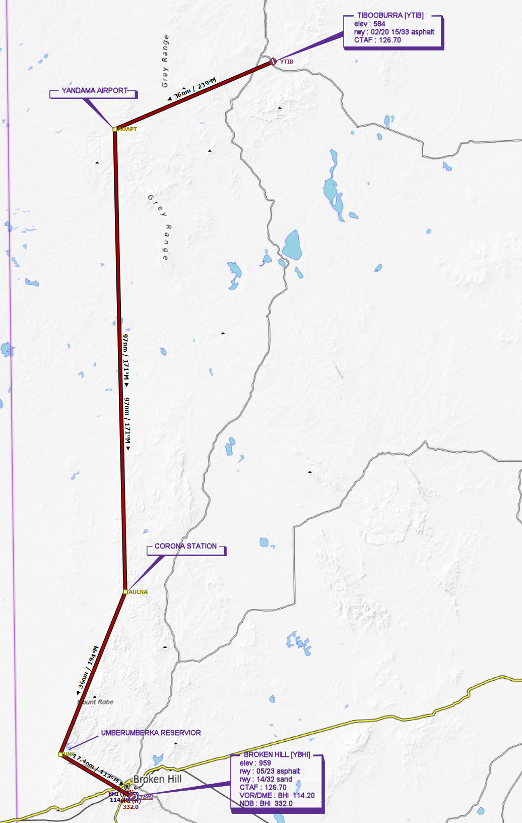
This week VFR Operations departs Tibooburra and returns to Broken Hill visiting a couple of small isolated airfields. FSX and P3D fliers will no airport scenery to view, however it is possible those flying in X-Plane who have installed appropriate Australian scenery will have somewhere to execute a touch and go at their discretion.
Simulation Date/Time : Current date set to daylight.
Weather : Real World / Fair weather if real world is unsuitable for VFR operations.
Distance : 186 nm
Est Flight Time : approx 85 mins
Aircraft : Single or twin engine aircraft such as Beechcraft Baron, Mooney Bravo or similar capable of 155 to 185 kias.
Communications : Australia uses CTAF (Common Traffic Advisory Frequency) for radio comms at uncontrolled airfields. VATSIM pilots connecting to the network using FSCOPILOT/FSINN can install an additional file that provides the ability to tune the CTAF frequency and make voice announcements to other pilots on frequency. These files can be obtained via this link.
For pilots connecting to VATSIM using VPilot, there is a work around that enables these pilots to also take advantage of online voice CTAF. Refer to this informative VATPAC Forum post to learn how to implement the work around. Similarly, this work around has been reported to be successfully adopted for X-Plane using the X-Squawkbox client. As of yet there are no available instructions for doing this.
Altitude : Not above FL125
Flightplan
File as : YTIB YANDAMA CORONA.STATION YBHI
GPS Flightplan is available for FSX and X-Plane FMS and also provided is the original Plan-G flightplan for those that find this useful all enclosed within a Zip archive.
Navigation : Pilots familiar with the area can navigate visually, for those less familiar the accompanying GPS Flightplan is the recommended method of navigating the flight plan.
Recommended Scenery
Flight Details
-
TIBOOBURRA [YTIB] Takeoff
elev : 584
rwy : 02/20 15/33 asphalt
CTAF : 126.70 -
YANDAMA AIRPORT Overfly - H-238° D-35.8 nm
-
CORONA STATION Overfly - H-171° D-96.5 nm
-
UMBERUMBERKA RESERVIOR Overfly - H-194° D-36.4 nm
-
BROKEN HILL [YBHI] Land - H-113° D-17.4 nm
elev : 959
rwy : 05/23 asphalt
rwy : 14/32 sand
CTAF : 126.70
VOR/DME : BHI BROKEN HILL 114.20
NDB : BHI BROKEN HILL 332.0
Chart