Event created by Russell D - 1104622

Event Details
Simulation Date/Time : Current date set to daylight.
Weather : Real World / Fair weather if real world is unsuitable for VFR operations.
Distance : 209 nm
Est Flight Time : approx 80 mins
Aircraft : Single or twin engine aircraft such as Beechcraft King Air, Pilatus PC-12 or similar capable of 200+ kias.
Communications : Australia uses CTAF (Common Traffic Advisory Frequency) for radio comms at uncontrolled airfields. VATSIM pilots connecting to the network using FSCOPILOT/FSINN can install an additional file that provides the ability to tune the CTAF frequency and make voice announcements to other pilots on frequency. These files can be obtained via this link.
For pilots connecting to VATSIM using VPilot, there is a work around that enables these pilots to also take advantage of online voice CTAF. Refer to this informative VATPAC Forum post to learn how to implement the work around. Similarly, this work around has been reported to be successfully adopted for X-Plane using the X-Squawkbox client. As of yet there are no available instructions for doing this.
Altitude : Not above FL125
Flightplan
File as : YCIN YDBY LONGISL SUNISL ARDYA YCLQ YLBD YBGB JMPP WCK YBRM
GPS Flightplan is available for FSX and X-Plane FMS and also provided is the original Plan-G flightplan for those that find this useful all enclosed within a Zip archive.
Navigation : Pilots familiar with the area can navigate visually, for those less familiar the accompanying GPS Flightplan is the recommended method of navigating the flight plan.
Recommended Scenery
- Beagle Bay Pearl Farm - Alan Blencoe
- Beagle Bay Community YBGB
- ORBX Australia
- ANTS AUSSIE AIRPORTS
- OZX 3.5 AU Scenery
Flight Details
-
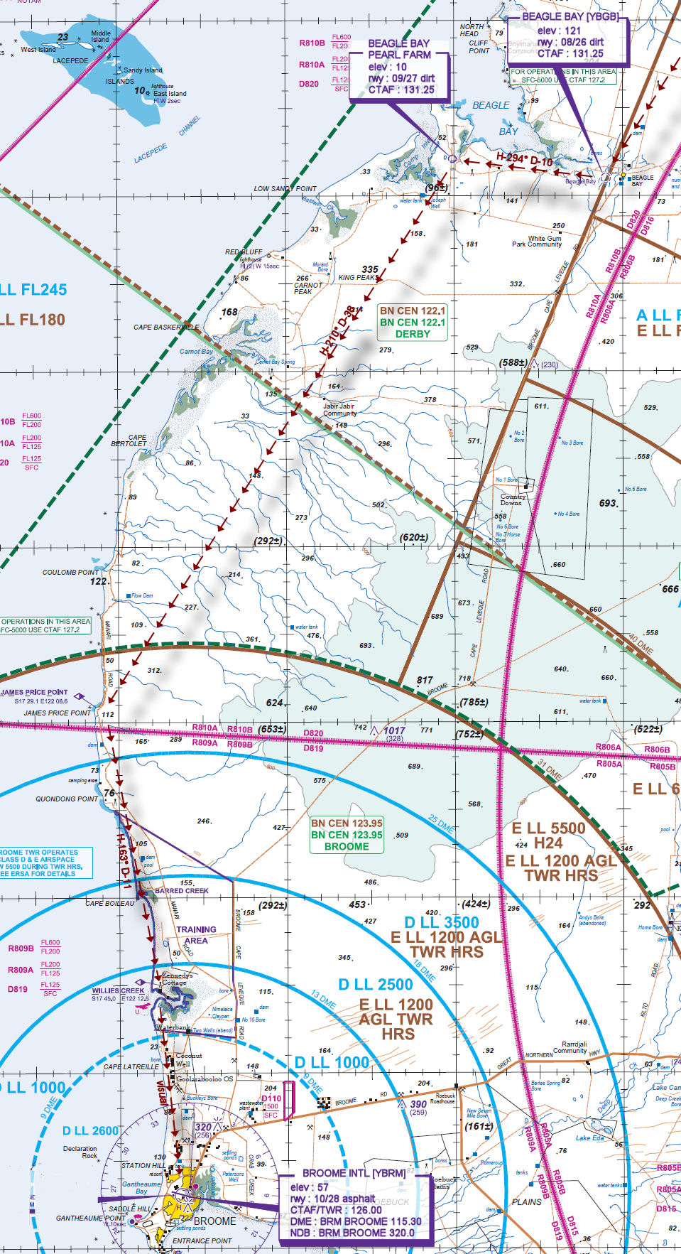
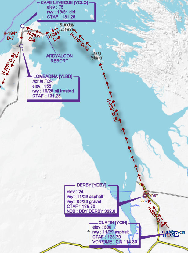
CURTIN [YCIN] Takeoff
elev : 300
rwy : 11/29 asphalt
CTAF : 126.70
VOR/DME : CIN CURTIN 114.30 -
DERBY [YDBY] T&G - H-320° D-15.9 nm
elev : 24
rwy : 11/29 asphalt
rwy : 05/23 gravel
CTAF : 126.70
NDB : DBY DERBY 332.0 -
LONG ISLAND [LONGISL] Overfly - H-338° D-50.6 nm
-
SUNDAY ISLAND [SUNISL] Overfly - H-310° D-14.4 nm
-
ARDYALOON RESORT [ARDYA] Overfly - H-251° D-7.6 nm
-
CAPE LEVEQUE [YCLQ] T&G - H-287° D-8.1 nm
elev : 75
rwy : 13/31 dirt
CTAF : 127.20 (FSINN 131.25) -
LOMBADINA [YLBD] T&G - H-184° D-7.1 nm
not in FSX
elev : 155
rwy : 10/28 oil treated
CTAF : 131.25 -
BEAGLE BAY [YBGB] T&G - H-205° D-33.7 nm
elev : 121
rwy : 08/26 dirt
CTAF : 131.25 -
BEAGLE BAY PEARL FARM T&G - H-294° D-9.5 nm
elev : 10
rwy : 09/27 dirt
CTAF : 131.25 -
JAMES PRICE POINT [JMPP] Overfly - H-210° D-38.1 nm
-
WILLIES CREEK [WCK] Overfly - H-163° D-10.6 nm
-
BROOME INTL [YBRM] Land - visual D~18 nm
elev : 57
rwy : 10/28 asphalt
CTAF/TWR : 126.00
DME : BRM BROOME 115.30
NDB : BRM BROOME 320.0
WAN Chart
VTC Chart