Event created by Russell D - 1104622

Event Details
This flight takes place in amongst the Torres Strait islands in the far north of Australia. Pilots using FSX will need to ensure they install the additional Ozx Torres Straits islands package and optionally the FTX freeware package for Murray Island. Links to these can be found below in the Scenery section.
Simulation Date/Time : Current date set to daylight.
Weather : Real World / Fair weather if real world is unsuitable for VFR operations.
Distance :120 nm
Est Flight Time : approx 70 mins
Aircraft :Single or twin engine aircraft such as Cessna 172, Britten BN2 Islander or similar capable of 105 to 135 kias.
Communications : Australia uses CTAF (Common Traffic Advisory Frequency) for radio comms at uncontrolled airfields. VATSIM pilots connecting to the network using FSCOPILOT/FSINN can install an additional file that provides the ability to tune the CTAF frequency and make voice announcements to other pilots on frequency. These files can be obtained via this link.
Altitude : Not above FL125
Flightplan
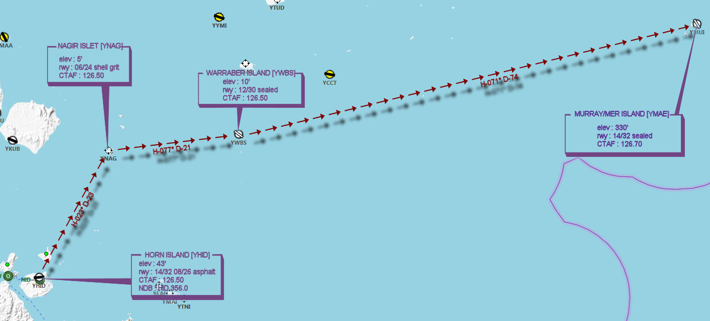
File as : YHID YNAG YWBS YMAE
Navigation : Pilots are advised to navigate this flight using the accompanying GPS Flightplan.
GPS Flightplan is available for FSX and X-Plane FMS and also provided is the original Plan-G flightplan for those that find this useful all enclosed within a Zip archive.
Recommended Scenery :
- OZx Torres Strait Islands Addon
- Old Version - MB Torres Straight Islands Package, Horn, Kubin, Badu and Tuin Islands
- FTX Murray Island Airport
- ORBX Australia
- ANTS AUSSIE AIRPORTS
- OZX AU Scenery
Flight Details
-
HORN ISLAND [YHID] Takeoff
elev : 43'
rwy : 14/32 08/26 asphalt
CTAF : 126.50
NDB : HID 356.0 -
NAGIR ISLET [YNAG] T&G - H-023° D-22.9 nm
elev : 5'
rwy : 06/24 shell grit
CTAF : 126.50 -
WARRABER ISLAND [YWBS] T&G - H-077° D-20.8 nm
elev : 10'
rwy : 12/30 sealed
CTAF : 126.50 -
MURRAY ISLAND [YMAE] (formerly YMUI) Land - H-071° D-74.7 nm
elev : 330'
rwy : 14/32 sealed
CTAF : 126.70
Chart