Event created by Russell D - 1104622

Event Details
Simulation Date/Time : Current date set to daylight.
Weather : Real World / Fair weather if real world is unsuitable for VFR operations.
Distance : 120 nm
Est Flight Time : approx 80 mins
Aircraft : Single piston engine aircraft such as Cessna 172 or similar capable of 105 to 135 kias.
Altitude : Remain below Launceston and Hobart CTA steps
Flightplan
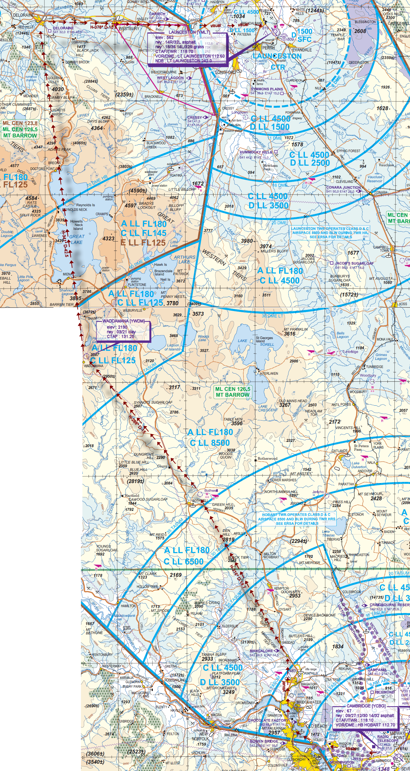
File as : YCBG BOWB COY MGL BOTHWL YWDM DEL CIK YMLT
GPS Flightplan is available for FSX and X-Plane FMS and also provided is the original Plan-G flightplan for those that find this useful all enclosed within a Zip archive.
Navigation : Pilots familiar with the area can navigate visually, for those less familiar the accompanying GPS Flightplan is the recommended method of navigating the flight plan.
Communications
Australia uses CTAF (Common Traffic Advisory Frequency) for radio comms at uncontrolled airfields. Now that VATSIM has introduced AFV (Audio For VATSIM) CTAF can now be used across all VATSIM approved pilot clients. Pilots are requested to tune to the published frequency as detailed in the flight details for an event when operating in or around an aerodome to make and monitor CTAF broadcasts. Pilots should also be aware that it is a VATSIM COC (Code of Conduct) requirement that all pilots at uncontrolled airfields should monitor Unicom (Australia 122.80). It is highly recommended that pilots ensure that at least one of their "on board" COM radios (COM 2 being the most likely) is tuned to receive unicom transmissions in addition to transmitting and receiving on the published CTAF frequency. Please Note. All pilots should also be vigilant regarding the receipt of text on both unicom and CTAF. If it is discovered there is a pilot participating that is unable to receive voice transmissions, pilots should arrange to also broadcast via text to ensure those pilots without the benefit of voice is able to receive appropriate broadcasts. VATSIM provides an update guide for getting AFV working on each of the approved pilot clients.
Recommended Scenery
FSX / P3D
X-Plane 10/11
Flight Details
-
CAMBRIDGE [YCBG] Takeoff
elev : 67
rwy : 09/27 12/30 14/32 asphalt
CTAF/TWR : 118.10
VOR/DME : HB HOBART 112.70
Check to see if Hobart Tower is active. If so, contact them to arrange a VFR Departure via "VICTOR WEST" -
BOWEN BRIDGE [BOWB] Overfly - via VICTOR WEST
-
CHOCOLATE FACTORY [COY] Overfly - H-296° D-2.3 nm
-
MANGALORE [MGL] Overfly - H-337° D-8.3 nm
-
BOTHWELL Overfly - H-316° D-19.7 nm
-
WADDAMANA [YWDM] T&G - H-288° D-15 nm
elev : 2190
rwy : 03/21 clay
CTAF : 131.25 -
DELORAINE [DEL] Overfly - H-341° D-42.5 nm
*** NOTE : X-Plane pilots have the opportunity to visit YDEL Deloraine Airport at their discretion. No details available at the time this was published. -
CARRICK [CIK] Overfly - H-078° D-15.6 nm
Launceston Inbound Reporting point
Contact Launie Appr or Tower if active and announce intentions. Do not proceed until instructed to do so -
LAUNCESTON [YMLT] Land - H-080° D-9.3 nm
elev : 562
rwy : 14R/32L asphalt
rwy : 18/36 14L/32R grass
CTAF/TWR : 118.70
NDB : LT LAUNCESTON 242.0
NDB : LT LAUNCESTON LAUNCESTON TAS 242.0
VOR/DME : LT LAUNCESTON 112.60
Chart