Event created by Russell D - 1104622

Event Details
Simulation Date/Time : Current date set to daylight.
Weather : Real World / Fair weather if real world is unsuitable for VFR operations.
Distance : 98 nm
Est Flight Time : approx 75 mins
Aircraft : Single piston engine aircraft such as Cessna 172, Piper Arrow or similar capable of 105 to 125 kias.
Communications
Australia uses CTAF (Common Traffic Advisory Frequency) for radio comms at uncontrolled airfields.
FSCopilot/FSInn
VATSIM pilots connecting to the network using FSCOPILOT/FSINN can install an additional file that provides the ability to tune the CTAF frequency and make voice announcements to other pilots on frequency. These files can be obtained via this link.
Swift
Swift is a recent VATSIM Pilot Client alternative now released to the public as a beta release candidate. This pilot client is a one fits all alternative and will work with FSX, P3D V3/V4 and XPlane in either 32 bit Windows or 64 bit Windows, Mac and Linux. This client, once installed and configured (not for the faint of heart - some guidance can be found in this video tutorial for those with X-Plane on Windows x64), also provides a capability for pilots to designate a private voice channel to allow communication with other pilots in the same voice channel. However, to do this requires a frequency over ride to be set allowing the client to ignore the set frequency instead providing text entry into a text box. Into this box the name of the voice room needs to be entered to enable voice communication. A voice room is typically in the form of "some.server.org/<Airport ICAO>". The server component is ALWAYS "rw1.vatpac.org". So this week's departure would use "rw1.vatpac.org/<Airport ICAO>".
For airports without an airport ICAO it is typical to use VATPAC VFR Virtual voice room acccessed using 131.25 in FSINN. The equivalent for SWIFT is "rw1.vatpac.org/virtualvfr".
Altitude : Below Sunshine Coast CTA Steps until entry is required to land
Flightplan
File as : YKRY YNAN YWSG YSMS YLAB EMD YBSU
GPS Flightplan is available for FSX and X-Plane FMS and also provided is the original Plan-G flightplan for those that find this useful all enclosed within a Zip archive.
Navigation : Pilots familiar with the area can navigate visually, for those less familiar the accompanying GPS Flightplan is the recommended method of navigating the flight plan.
NOTE : Following the GPS flighplan will result in pilots entering restricted airspace. Allowances will be required to avoid entering restricted airspace.
Recommended Scenery
FSX / P3D
X-Plane 10/11
SUNSHINE COAST (formerly MAROOCHYDORE YBMC) VFR PROCEDURES
Sunshine Coast is a class C civil and general aviation aerodrome and is located in close proximity to high terrain in the west. CASA's "On Track" resource provided clear and concise guidance to pilot however it is not available whilst it undergoes an overdue revision. As an alternative resource the accompanying video is available on youtube via this link and is highly recommended as a means of becoming familiar with VFR procedures in and around Sunshine Coast. For this flight, take particular note for arrivals from the south west via Ewan Maddock Dam and Nambour
Flight Details
* NOTE Frequency 131.25 - "rw1.vatpac.org/virtualvfr"
-
KINGAROY [YKRY] Takeoff
elev : 1492
rwy : 05/23 grass
rwy : 16/34ns asphalt
CTAF : 127.45 (FSINN 126.70) -
NANANGO [YNAN] T&G - H-118° D-10
elev : 1194
rwy : 05/23 dirt
CTAF : 131.25 -
WATTS BRIDGE [YWSG] T&G - H-124° D-35
elev : 298
rwy : 03/21 12/30 grass
CTAF : 127.30 -
SOMMERSET DAM T&G - H-090° D-8
(Scenery not depicted in X-Plane)
elev : 452
rwy : 01/19 grass
CTAF : 131.25 -
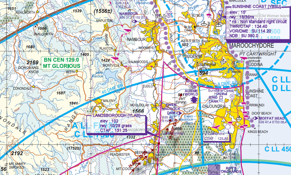
LANDSBOROUGH [YLAB] T&G - H-040° D-26
elev : 102
rwy : 10/28 grass
CTAF : 131.25 -
EWAN MADDOCK DAM [EMD] Overfly - H-020° D-3
INBOUND REPORTING POINT is ATC is active Sunshine coast - Direct to YBSU will be provided unless airspace is busy otherwise expect entry via NAMBOUR -
SUNSHINE COAST [YBSU] Land - H-067° D-7
elev : 15
rwy : 12/30 18/36ns asphalt
CTAF/TWR : 124.40 (FSINN 131.25)
VOR/DME : SU SUNSHINE COAST 114.20
NDB : SU SUNSHINE COAST 380.0
WAN Chart

Sunshine Coast VTC