Event created by Russell D - 1104622
Event Details
Simulation Date/Time : Current date set to daylight.
Weather : Real World / Fair weather if real world is unsuitable for VFR operations.
Distance : 193 nm
Est Flight Time : approx 85 mins
Aircraft : Single or piston engine aircraft such as Mooney Bravo, Beechcraft Bonanza or similar capable of between 150-170 kias.
Communications
Use Unicom 122.80 for radio comms at all airfields.
FSCopilot/FSInn
VATSIM pilots connecting to the network using FSCOPILOT/FSINN can install an additional file that provides the ability to tune the CTAF frequency and make voice announcements to other pilots on frequency. These files can be obtained via this link.
Swift
Swift is a recent VATSIM Pilot Client alternative now released to the public as a beta release candidate. This pilot client is a one fits all alternative and will work with FSX, P3D V3/V4 and XPlane in either 32 bit Windows or 64 bit Windows, Mac and Linux. The client is a little challenging to get installed and configured. Some further guidance can be found in this video tutorial for those with X-Plane on Windows x64).
Altitude : Not above A6500
Flightplan
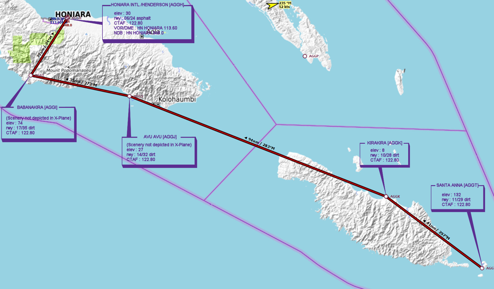
File as : AGGT AGGK AGGJ AGGI AGGH
GPS Flightplan is available for FSX and X-Plane FMS and also provided is the original Plan-G flightplan for those that find this useful all enclosed within a Zip archive.
Navigation : Pilots familiar with the area can navigate visually, for those less familiar the accompanying GPS Flightplan is the recommended method of navigating the flight plan.
Recommended Scenery
FSX / P3D
- Default scenery
X-Plane 10/11
- Default scenery
Flight Details
-
SANTA ANNA [AGGT] Takeoff
elev : 132
rwy : 11/29 dirt
CTAF : 122.80 -
KIRAKIRA [AGGK] T&G - H-298° D-41
elev : 8
rwy : 10/28 dirt
CTAF : 122.80 -
AVU AVU [AGGJ] T&G - H-281° D-94
(Scenery not depicted in X-Plane)
elev : 27
rwy : 14/32 dirt
CTAF : 122.80 -
BABANAKIRA [AGGI] T&G - H-273° D-35
(Scenery not depicted in X-Plane)
elev : 74
rwy : 17/35 dirt
CTAF : 122.80 -
HONIARA INTL /HENDERSON [AGGH] Land - H-024° D-23
elev : 30
rwy : 06/24 asphalt
CTAF : 122.80
VOR/DME : HN HONIARA 113.60
NDB : HN HONIARA 348.0
Chart