Event created by Russell D - 1104622

Event Details
Simulation Date/Time : Current date set to daylight.
Weather : Real World / Fair weather if real world is unsuitable for VFR operations.
Distance : 145 nm
Est Flight Time : approx 80 mins
Aircraft : Single piston engine aircraft such as Cessna 172, Orion Maule or similar capable of 115 to 135 kias.
Communications
Australia uses CTAF (Common Traffic Advisory Frequency) for radio comms at uncontrolled airfields.
FSCopilot/FSInn
VATSIM pilots connecting to the network using FSCOPILOT/FSINN can install an additional file that provides the ability to tune the CTAF frequency and make voice announcements to other pilots on frequency. These files can be obtained via this link.
Swift
Swift is a recent VATSIM Pilot Client alternative now released to the public as a beta release candidate. This pilot client is a one fits all alternative and will work with FSX, P3D V3/V4 and XPlane in either 32 bit Windows or 64 bit Windows, Mac and Linux. This client, once installed and configured (not for the faint of heart - some guidance can be found in this video tutorial for those with X-Plane on Windows x64), also provides a capability for pilots to designate a private voice channel to allow communication with other pilots in the same voice channel. However, to do this requires a frequency over ride to be set allowing the client to ignore the set frequency instead providing text entry into a text box. Into this box the name of the voice room needs to be entered to enable voice communication. A voice room is typically in the form of "some.server.org/<Airport ICAO>". The server component is ALWAYS "rw1.vatpac.org". So this week's departure would use "rw1.vatpac.org/<Airport ICAO>".
For airports without an airport ICAO it is typical to use VATPAC VFR Virtual voice room acccessed using 131.25 in FSINN. The equivalent for SWIFT is "rw1.vatpac.org/virtualvfr".
Altitude : Remain OCTA below Class C & D Tamworth Steps. If ATC is active clearance will be required prior to passing Duri Gap
Flightplan
File as : YMDG YGGG YBUT YCAH YADU YBVL YQDI WEK GST DUA YSTW
GPS Flightplan is available for FSX and X-Plane FMS and also provided is the original Plan-G flightplan for those that find this useful all enclosed within a Zip archive.
Navigation : Pilots familiar with the area can navigate visually, for those less familiar the accompanying GPS Flightplan is the recommended method of navigating the flight plan.
Recommended Scenery
FSX / P3D
X-Plane 10/11
Flight Details
* NOTE Frequency 131.25 - "rw1.vatpac.org/virtualvfr"
-
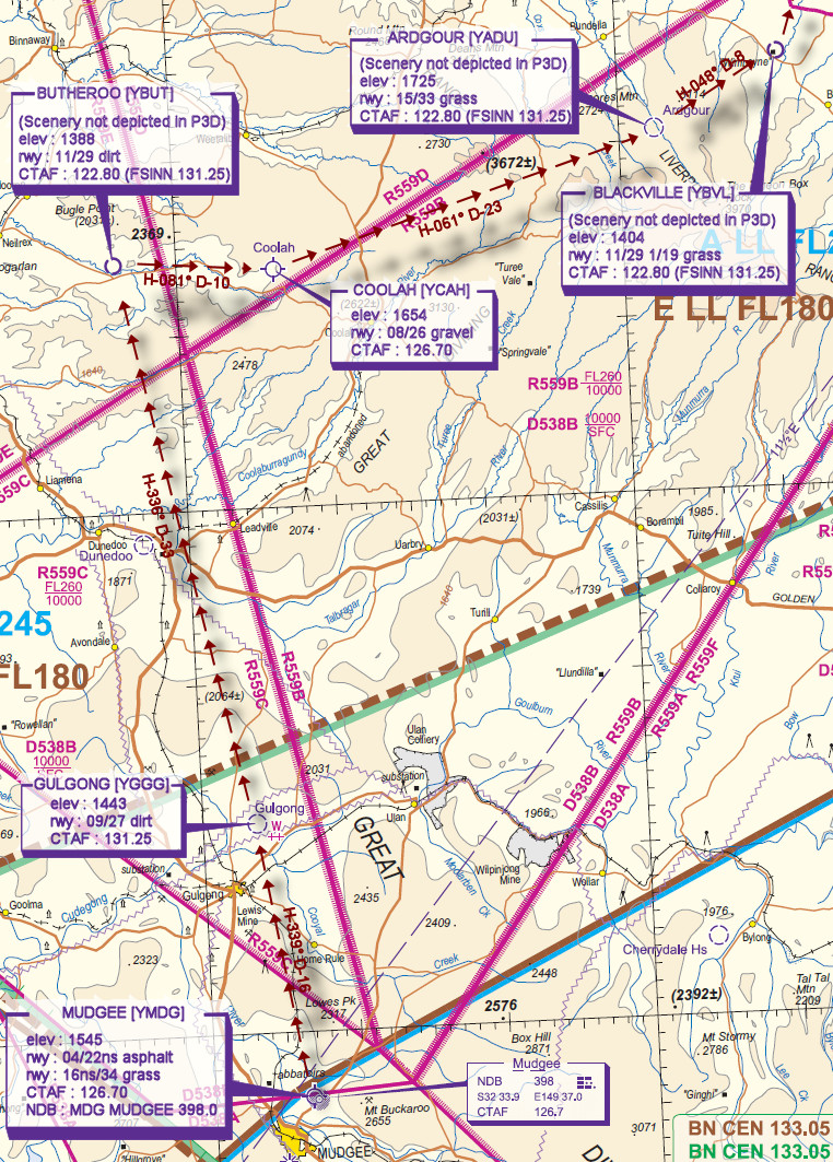
MUDGEE [YMDG] Takeoff
elev : 1545
rwy : 04/22ns asphalt
rwy : 16ns/34 grass
CTAF : 126.70
NDB : MDG MUDGEE 398.0 -
GULGONG [YGGG] T&G - H-339° D-16
elev : 1443
rwy : 09/27 dirt
CTAF : 131.25 -
BUTHEROO [YBUT] T&G - H-336° D-33
(Scenery not depicted in P3D)
elev : 1388
rwy : 11/29 dirt
CTAF : 122.80 (FSINN 131.25) -
COOLAH [YCAH] T&G - H-081° D-10
elev : 1654
rwy : 08/26 gravel
CTAF : 126.70 -
ARDGOUR [YADU] T&G - H-061° D-23
(Scenery not depicted in P3D)
elev : 1725
rwy : 15/33 grass
CTAF : 122.80 (FSINN 131.25) -
BLACKVILLE [YBVL] T&G - H-048° D-8
(Scenery not depicted in P3D)
elev : 1404
rwy : 11/29 1/19 grass
CTAF : 122.80 (FSINN 131.25) -
QUIRINDI [YQDI] T&G - H-060° D-18
elev : 1058
rwy : 06/24 14/32 asphalt
CTAF : 127.80
NDB : QDI QUIRINDI 386.0 -
WERRIS CREEK [WEK] Overfly - H-029° D-11
-
GATE SOUTH [GST] Overfly - H-012° D-5 not above A3500
-
DURI GAP [DUA] Overfly - H-356° D-6 not above A3500
IF ATC active obtain clearance to enter Tamworth CTA -
TAMWORTH [YSTW] Land - H-035° D-10
elev : 1334
rwy : 12R/30L 12L/30R asphalt
rwy : 06/24 18/36 grass
CTAF/TWR : 119.40
NDB : TW TAMWORTH 341.0
VOR/DME : TW TAMWORTH 116.00
Tamworth VTC

Mudgee to Tamworth VNC