Event created by Russell D - 1104622
Event Details
This flight provides an opportunity to explore the NASA Space Centre in Florida. Pilots using X-Plane have some additional scenery to compliment the existing default for the area. This scenery is set post Shuttle and depicts the current practice of launching unmanned vehicles. Those flying legacy FSX have default scenery depicting the launch and retrieval of Shuttle missions.
Atypically, pilots are encouraged to fly a small jet aircraft. This is to emulate the use of the Northrop T38 Talon used by NASA astronauts as their personal qualifying and taxi service. So pilots with the aircraft in their personal hangar are encouraged to use it for the flight.
Simulation Date/Time : Current date set to daylight.
Weather : Real World / Fair weather if real world is unsuitable for VFR operations.
Distance : 160 nm
Est Flight Time : approx 65 mins
Aircraft : Small single or twin engine jet aircraft such as Cirrus Vision, Pilatus PC-24, Northrop T-38 Talon or similar capable of up to 250 kias below A10,000.
Communications
United States uses Unicom 122.80 for radio comms at all airfields.
FSCopilot/FSInn
VATSIM pilots connecting to the network using FSCOPILOT/FSINN can install an additional file that provides the ability to tune the CTAF frequency and make voice announcements to other pilots on frequency. These files can be obtained via this link.
Swift
Swift is a recent VATSIM Pilot Client alternative now released to the public as a beta release candidate. This pilot client is a one fits all alternative and will work with FSX, P3D V3/V4 and XPlane in either 32 bit Windows or 64 bit Windows, Mac and Linux. The client is a little challenging to get installed and configured. Some further guidance can be found in this video tutorial for those with X-Plane on Windows x64).
Altitude : Not above A6500
Flightplan
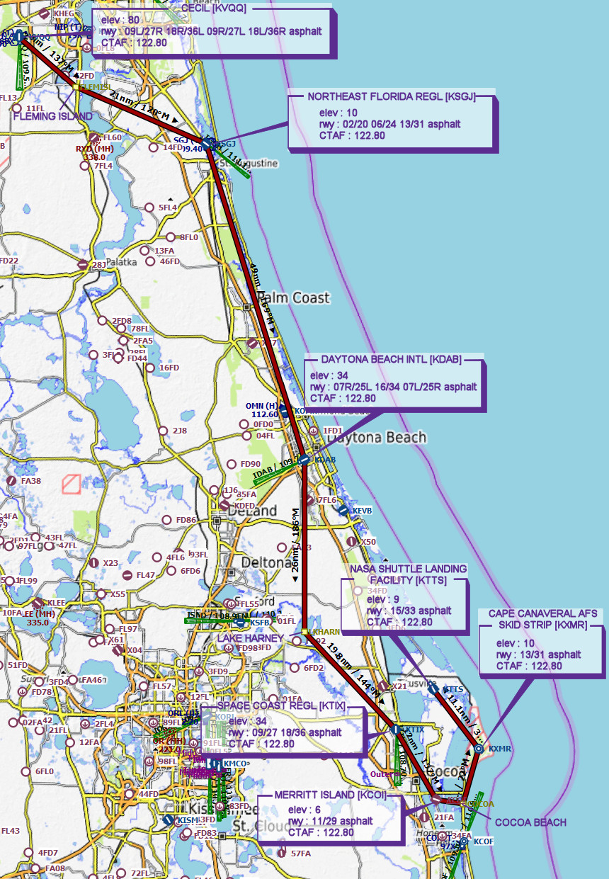
File as : KVQQ KSGJ KDAB KTIX KCOI COCOA.BEACH KXMR KTTS
GPS Flightplan is available for FSX and X-Plane FMS and also provided is the original Plan-G flightplan for those that find this useful all enclosed within a Zip archive.
Navigation : Pilots familiar with the area can navigate visually, for those less familiar the accompanying GPS Flightplan is the recommended method of navigating the flight plan.
Recommended Scenery
FSX / P3D
-
Default scenery - FSX depicts the area during the latter days of the Shuttle Era
The depiction in P3D is unknown at the time of publishing this event
X-Plane 10/11
-
KXMR Cape Canaveral Air Force Station 3.5
Depicts the area post Space Shuttle
Flight Details
* NOTE Frequency 131.25 - "rw1.vatpac.org/virtualvfr"
-
CECIL [KVQQ] Takeoff
elev : 80
rwy : 09L/27R 18R/36L 09R/27L 18L/36R asphalt
CTAF : 122.80 -
FLEMING ISLAND Overfly - H-135° D-11
-
NORTHEAST FLORIDA REGL [KSGJ] T&G - H-118° D-21
elev : 10
rwy : 02/20 06/24 13/31 asphalt
CTAF : 122.80 -
DAYTONA BEACH INTL [KDAB] T&G - H-167° D-49
elev : 34
rwy : 07R/25L 16/34 07L/25R asphalt
CTAF : 122.80 -
LAKE HARNEY Overfly - H-185° D-26
-
SPACE COAST REGL [KTIX] T&G - H-142° D-20
elev : 34
rwy : 09/27 18/36 asphalt
CTAF : 122.80 -
MERRITT ISLAND [KCOI] T&G - H-155° D-12
elev : 6
rwy : 11/29 asphalt
CTAF : 122.80 -
COCOA BEACH Overfly - H-102° D-4
-
CAPE CANAVERAL AFS SKID STRIP [KXMR] T&G - H-021° D-8
elev : 10
rwy : 13/31 asphalt
CTAF : 122.80 -
NASA SHUTTLE LANDING FACILITY [KTTS] Land - H-326° D-11
elev : 9
rwy : 15/33 asphalt
CTAF : 122.80
Chart