Event created by Russell D - 1104622

Event Details
Simulation Date/Time : Current date set to daylight.
Weather : Real World / Fair weather if real world is unsuitable for VFR operations.
Distance : 110 nm
Est Flight Time : approx 80 mins
Aircraft : Single piston engine aircraft such as Cessna 172, Piper Warrior, Orion Maule or similar capable of 105 to 125 kias.
Communications
Australia uses CTAF (Common Traffic Advisory Frequency) for radio comms at uncontrolled airfields.
FSCopilot/FSInn
VATSIM pilots connecting to the network using FSCOPILOT/FSINN can install an additional file that provides the ability to tune the CTAF frequency and make voice announcements to other pilots on frequency. These files can be obtained via this link.
Swift
Swift is a recent VATSIM Pilot Client alternative now released to the public as a beta release candidate. This pilot client is a one fits all alternative and will work with FSX, P3D V3/V4 and XPlane in either 32 bit Windows or 64 bit Windows, Mac and Linux. This client, once installed and configured (not for the faint of heart - some guidance can be found in this video tutorial for those with X-Plane on Windows x64), also provides a capability for pilots to designate a private voice channel to allow communication with other pilots in the same voice channel. However, to do this requires a frequency over ride to be set allowing the client to ignore the set frequency instead providing text entry into a text box. Into this box the name of the voice room needs to be entered to enable voice communication. A voice room is typically in the form of "some.server.org/<Airport ICAO>". The server component is ALWAYS "rw1.vatpac.org". So this week's departure would use "rw1.vatpac.org/<Airport ICAO>".
For airports without an airport ICAO it is typical to use VATPAC VFR Virtual voice room acccessed using 131.25 in FSINN. The equivalent for SWIFT is "rw1.vatpac.org/virtualvfr".
Altitude : Not above FL125
Flightplan
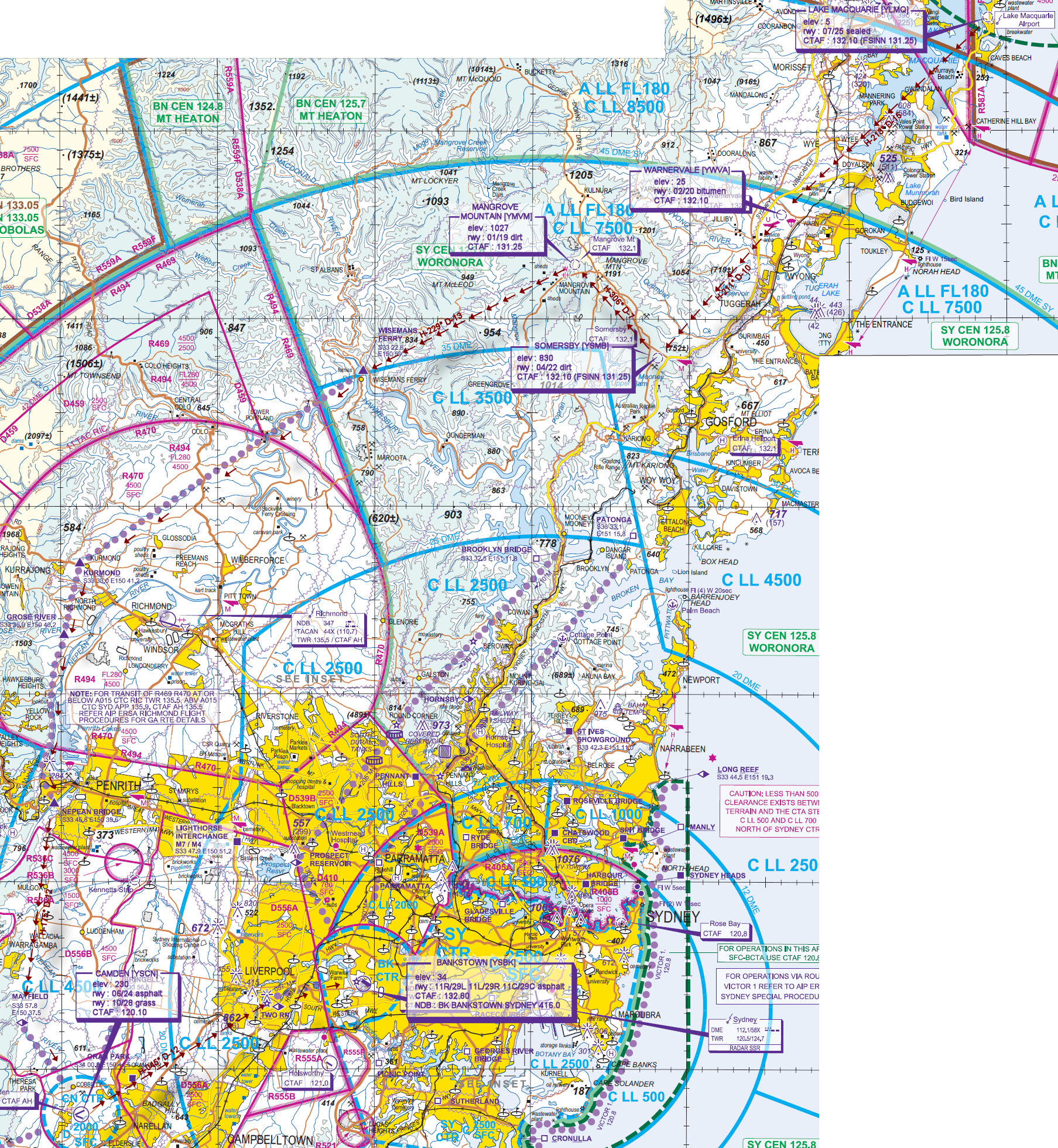
File as : YLMQ YWVA YSOM YMVM WSMF KRMD NEPN MYF YSCN TWRN YSBK
GPS Flightplan is available for FSX and X-Plane FMS and also provided is the original Plan-G flightplan for those that find this useful all enclosed within a Zip archive.
Navigation : Pilots familiar with the area can navigate visually, for those less familiar the accompanying GPS Flightplan is the recommended method of navigating the flight plan.
Recommended Scenery
- ORBX Australia
- ANTS AUSSIE AIRPORTS
- OZX 3.5 AU Scenery
- Bazz's Australian and PNG Scenery for X-Plane
- Sydney Overlay
Flight Details
* NOTE Frequency 131.25 - "rw1.vatpac.org/virtualvfr"
-
LAKE MACQUARIE [YLMQ] Takeoff
Formerly Aeropelican [YPEC]
elev : 5
rwy : 07/25 sealed
CTAF : 132.10 (FSINN 131.25) -
WARNERVALE [YWVA] T&G - H-213° D-15
elev : 25
rwy : 02/20 bitumen
CTAF : 132.10 -
SOMERSBY [YSMB] T&G - H-211° D-10
elev : 830
rwy : 04/22 dirt
CTAF : 132.10 (FSINN 131.25) -
MANGROVE MOUNTAIN [YMVM] T&G - H-306° D-7
elev : 1027
rwy : 01/19 dirt
CTAF : 131.25 -
WISEMANS FERRY [WSMF] Overfly - H-229° D-13
IF RIC TWR active, request transit of R469/470 at or below A015 -
KURMOND [KRMD] Overfly - RIC VFR CORRIDOR D-18
-
NEPEAN BRIDGE [NEPN] Overfly - RIC VFR CORRIDOR D-13
-
MAYFIELD [MYF] Overfly - H-175° D-12
-
CAMDEN [YSCN] T&G - H-133° D-6
elev : 230
rwy : 06/24 asphalt
rwy : 10/28 grass
CTAF : 120.10 -
TWO RN [TWRN] Overfly - H-045° D-12
IF BANKSTOWN Tower is Active then contact them with an inbound call and do not proceed into the Bankstown Control Zone until instructed to do so
Typical call - "BANKSTOWN TOWER [AIRCRAFT TYPE][CALLSIGN] TWO RN 1500ft received information [ATIS IDENTIFIER] inbound" -
BANKSTOWN [YSBK] Land - H-069° D-5
elev : 34
rwy : 11R/29L 11L/29R 11C/29C asphalt
CTAF : 132.80
NDB : BK BANKSTOWN SYDNEY 416.0
Chart