Event created by Russell D - 1104622

Event Details
Simulation Date/Time : Current date set to daylight.
Weather : Real World / Fair weather if real world is unsuitable for VFR operations.
Distance : 156 nm
Est Flight Time : approx 80 mins
Aircraft : Single engine piston aircraft such as Mooney Bravo or similar capable of 145 to 175 kias.
Communications : Australia uses CTAF (Common Traffic Advisory Frequency) for radio comms at uncontrolled airfields. VATSIM pilots connecting to the network using FSCOPILOT/FSINN can install an additional file that provides the ability to tune the CTAF frequency and make voice announcements to other pilots on frequency. These files can be obtained via this link.
For pilots connecting to VATSIM using VPilot, there is a work around that enables these pilots to also take advantage of online voice CTAF. Refer to this informative VATPAC Forum post to learn how to implement the work around.
Altitude : Once clear of Parafield CTA, remain clear of Adelaide Class C airspace
Flightplan
File as : YWHA YPIR YARS DUB OHB YPPF
GPS Flightplan is available for FSX and X-Plane FMS and also provided is the original Plan-G flightplan for those that find this useful all enclosed within a Zip archive.
Navigation : Pilots familiar with the area can navigate visually, for those less familiar the accompanying GPS Flightplan is the recommended method of navigating the flight plan.
Recommended Scenery
- YPPF Afcad to correct FSX default taxiway and runways
- ORBX Australia
- ANTS AUSSIE AIRPORTS
- OZX AU Scenery
Flight Details
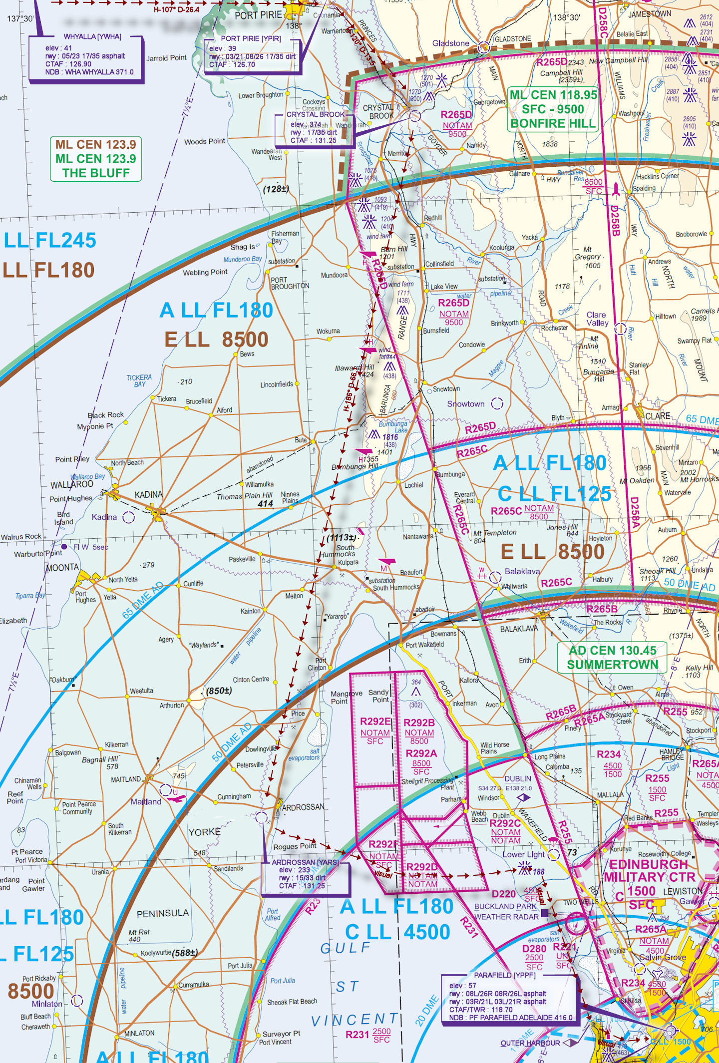
-
WHYALLA [YWHA] Takeoff
elev : 41
rwy : 05/23 17/35 asphalt
CTAF : 126.90
NDB : WHA WHYALLA 371.0 -
PORT PIRIE [YPIR] T&G - H-107° D-26.4 nm
elev : 39
rwy : 03/21 08/26 17/35 dirt
CTAF : 126.70 -
CRYSTAL BROOK T&G - H-120° D-13.5 nm
elev : 374
rwy : 17/35 dirt
CTAF : 131.25 -
ARDROSSAN [YARS] T&G - H-186° D-66.1 nm
elev : 233
rwy : 15/33 dirt
CTAF : 131.25 -
DUBLIN [DUB] Overfly - H-083° D-22.9 nm
-
OUTER HARBOUR [OHB] Overfly - H-153° D-20.3 nm
-
PARAFIELD [YPPF] Land - H-091° D-7.5 nm
elev : 57
rwy : 08L/26R 08R/26L 03R/21L 03L/21R asphalt
CTAF/TWR : 118.70
NDB : PF PARAFIELD ADELAIDE 416.0
Chart