Event created by Russell D - 1104622

Event Details
This easter weekend, VATPAC concludes it's Iron Mic attempt at Sydney. VFR Operations flies out and returns to Sydney Bankstown to add some GA traffic to the weekend's mix.
Simulation Date/Time : Current date set to daylight.
Weather : Real World / Fair weather if real world is unsuitable for VFR operations.
Distance : 108 nm
Est Flight Time : approx 70 mins
Aircraft : Single Engine Piston such as Cessna 172 or similar capable of 105 to 125 kias.
Communications : Australia uses CTAF (Common Traffic Advisory Frequency) for radio comms at uncontrolled airfields. VATSIM pilots connecting to the network using FSCOPILOT/FSINN can install an additional file that provides the ability to tune the CTAF frequency and make voice announcements to other pilots on frequency. These files can be obtained via this link.
Altitude : remain outside Sydney class C airspace
Flightplan
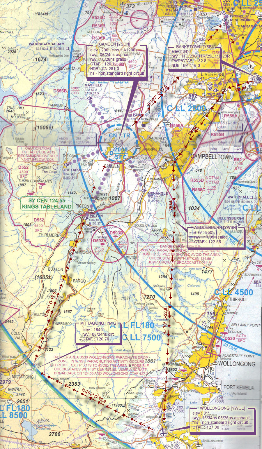
File as : YSBK YWBN YWOL YMIG PIC YSCN PSP YSBK
Navigation : Unless pilots are visually familiar with this area, the accompanying GPS Flightplan is recommended.
GPS Flightplan is available for FSX, FS9 and X-Plan FMS and also provided is the original Plan-G flightplan for those that find this useful all enclosed within a Zip archive.
Recommended Scenery
- X-Plane - Sydney
- Bankstown by By Robert Fluke (Flukey), Ben Odonnell (FBK289) & Garry Moore(GAZZA)
- ORBX Australia
- ANTS AUSSIE AIRPORTS
- OZX AU Scenery
BANKSTOWN PROCEDURES
Bankstown is a general aviation class D aerodrome and is located in close proximity to Sydney International Airport and RAAF Airbase Richmond. An excellent source of information for Bankstown VFR operations inbound and outbound can be found in CASA's "Ontrack" Online Reference Resource. Pilots unfamiliar with Bankstown Operations are encouraged to visit the site and review available information prior to operating within Bankstown airspace.
Flight Details
PILOTS SHOULD ENSURE THEY SET THEIR TRANSPONDER TO MODE "C" (normal) AS THEY ENTER THE RUNWAY SO ATC WILL SEE AIRCRAFT ALTITUDE IN THEIR SCOPE
-
BANKSTOWN [YSBK] Takeoff
elev : 34'
rwy : 11C/29C 11R/29L 11L/29R asphalt
TWR/CTAF : 132.80
NDB : BK 416.0 -
WEDDERBURN [YWBN] T&G - H-197° D-17.8
elev : 850'
rwy : 17/35 sealed
CTAF : 122.55 -
WOLLONGONG [YWOL] T&G - H-170° D-22.8
elev : 31'
rwy : 16/34ns 08/26ns asphalt
* ns - non-standard right circuit
CTAF : 127.30
NDB : WOL 239.0 -
MITTAGONG [YMIG] T&G - H-282° D-15.9
elev : 1840'
rwy : 06/24ns unsealed
* ns - non-standard right circuit
CTAF : 126.70 -
PICTON [PIC] Overfly - H-007° D-17.6
Inbound reporting point for Camden.
If TWR active set transponder 3000 and Call "CAMDEN TOWER [AIRCRAFT TYPE][CALLSIGN] Picton A1700 RECEIVED [ATIS ID] INBOUND"
DO NOT ENTER CONTROL ZONE UNLESS TWR HAS PROVIDED JOIN INSTRUCTIONS -
CAMDEN [YSCN] T&G - H-023° D-8.8
elev : 230' (circuit A1200)
rwy : 06/24ns asphalt
rwy : 10/28ns grass
* ns - non-standard right circuit
TWR/CTAF : 120.10
NDB : CN 281.0 -
PROSPECT RESERVOIR [PSP] Overfly - H-027° D-17.6
Inbound reporting point for Bankstown.
If TWR active set transponder 3000 and Call "BANKSTOWN TOWER [AIRCRAFT TYPE][CALLSIGN] Prospect Reservoir A1500 RECEIVED [ATIS ID] INBOUND"
DO NOT ENTER CONTROL ZONE UNLESS TWR HAS PROVIDED JOIN INSTRUCTIONS -
BANKSTOWN [YSBK] Land - H-151° D-7.4
Sydney VTC