Event created by Russell D - 1104622

Event Details
Simulation Date/Time : Current date set to daylight.
Weather : Real World / Fair weather if real world is unsuitable for VFR operations.
Distance : 191 nm
Est Flight Time : approx 85 mins
Aircraft : Single or twin engine piston aircraft such as Beechcraft Baron, Pilatus PC-12 or similar capable of 185 to 215 kias.
Communications : Australia uses CTAF (Common Traffic Advisory Frequency) for radio comms at uncontrolled airfields. VATSIM pilots connecting to the network using FSCOPILOT/FSINN can install an additional file that provides the ability to tune the CTAF frequency and make voice announcements to other pilots on frequency. These files can be obtained via this link.
For pilots connecting to VATSIM using VPilot, there is a work around that enables these pilots to also take advantage of online voice CTAF. Refer to this informative VATPAC Forum post to learn how to implement the work around.
Altitude : Not above FL125
Flightplan
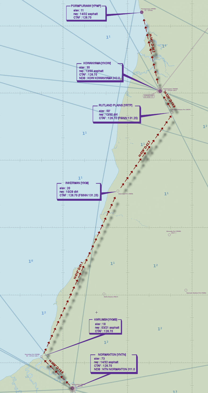
File as : YNTN YKMB YKIM YRTP YKOW YPMP
GPS Flightplan is available for FSX and X-Plane FMS and also provided is the original Plan-G flightplan for those that find this useful all enclosed within a Zip archive.
Navigation : Pilots familiar with the area can navigate visually, for those less familiar the accompanying GPS Flightplan is the recommended method of navigating the flight plan.
Recommended Scenery
Flight Details
-
NORMANTON [YNTN] Takeoff
elev : 73
rwy : 14/32 asphalt
CTAF : 126.70
NDB : NTN NORMANTON 311.0 -
KARUMBA [YKMB] T&G - H-309° D-19.6 nm
elev : 18
rwy : 03/21 asphalt
CTAF : 126.70 -
INKERMAN [YIKM] T&G - H-019° D-81.1 nm
elev : 20
rwy : 10/28 dirt
CTAF : 126.70 (FSINN 131.25) -
RUTLAND PLAINS [YRTP] T&G - H-029° D-42.7 nm
elev : 50'
rwy : 12/30 dirt
CTAF : 126.70 (FSINN 131.25) -
KOWANYAMA [YKOW] T&G - H-325° D-10.9 nm
elev : 35
rwy : 12/30 asphalt
CTAF : 126.70
NDB : KOW KOWANYAMA 242.0 -
PORMPURAAW [YPMP] Land - H-341° D-36.2 nm
elev : 11
rwy : 14/32 asphalt
CTAF : 126.70
Chart