Event created by Russell D - 1104622
Event Details
Simulation Date/Time : Current date set to daylight.
Weather : Real World / Fair weather if real world is unsuitable for VFR operations.
Distance :90 nm
Est Flight Time : approx 85 mins
Aircraft :Single engine aircraft such as Cessna 172 or similar capable of 105 to 125 kias.
Communications : Australia uses CTAF (Common Traffic Advisory Frequency) for radio comms at uncontrolled airfields. VATSIM pilots connecting to the network using FSCOPILOT/FSINN can install an additional file that provides the ability to tune the CTAF frequency and make voice announcements to other pilots on frequency. These files can be obtained via this link.
Altitude : As permitted by Sunshine Coast class C steps upto 9500
Flightplan
File as : YHBA YMYB YGYM CORO YBSU
GPS Flightplan is available for FSX, FS9 and X-Plan FMS and also provided is the original Plan-G flightplan for those that find this useful all enclosed within a Zip archive.
Navigation : Pilots familiar with the area can navigate visually, for those less familiar the accompanying GPS Flightplan is recommended method of navigating the flight plan.
Recommended Scenery
- ORBX Australia
- FTX Hervey Bay
- ANTS AUSSIE AIRPORTS
- OZX 3.5 AU Scenery
- FSX/P3D Sunshine Coast - Robert Fluke
SUNSHINE COAST (formerly MAROOCHYDORE YBMC) VFR PROCEDURES
Sunshine Coast is a class C civil and general aviation aerodrome and is located in close proximity to high terrain. An excellent source of information for Sunshine Coast VFR operations inbound and outbound can be found in CASA's "Ontrack" Online Reference Resource. Pilots unfamiliar with Sunshine Coast Operations are encouraged to visit the site and review available information (video is very informative) prior to operating within Sunshine Coast airspace.
In particular, review
- Inbound from the north west - NOTE during high traffic expect to be redirected YARINDA arrival (see Inbound from the west)
- Inbound from the west
Flight Details
-
HERVEY BAY [YHBA] Takeoff
elev : 60'
rwy : 11/29 asphalt
CTAF : 126.55 -
MARYBOROUGH [YMYB] T&G - H-206° D-15
elev : 38'
rwy : 17/35 asphalt
rwy : 12/30 grass
CTAF : 126.55 -
GOOMBOORIAN Fullstop - H-164° D-34
elev : 100'
rwy : 29 Land / 11 Takeoff - grass
CTAF : 131.25 -
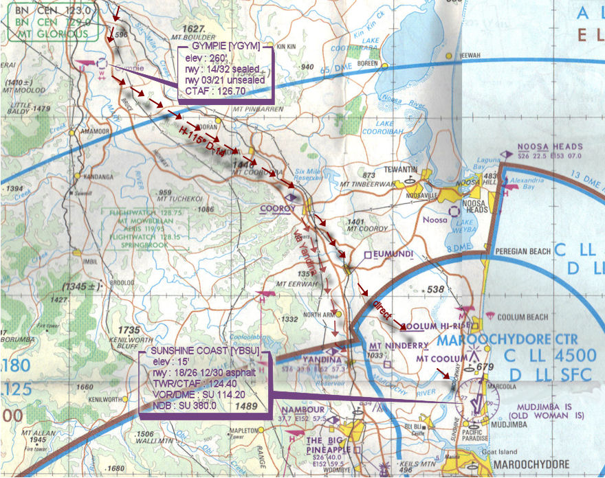
GYMPIE [YGYM] T&G - H-186° D-13
elev : 260'
rwy : 14/32 sealed
rwy 03/21 unsealed
CTAF : 126.70 -
COOROY [CORO] Overfly - H-115° D-14
INBOUND Reporting Point - If ATC active make inbound call.
SUNSHINE COAST [AIRCRAFT TYPE][CALLSIGN] COOROY 1500 RECEIVED INFORMATION [ATIS IDENTIFIER] INBOUND
ATC may have to redirect your aircraft via the WEST entry via YANDINA if commercial traffic is present -
EUMUNDI [EMI] Overfly only if ATC has cleared direct to YBSU - H-138° D-5 - **** IF ATC ACTIVE - DO NOT PROCEED BEYOND UNLESS ATC HAS CLEARED ENTRY OR PROVIDED JOIN INSTRUCTIONS
-
MAROOCHYDORE/SUNSHINE COAST [YBSU] Land - H-125° D-11
elev : 15'
rwy : 18/26 12/30 asphalt
TWR/CTAF : 124.40
VOR/DME : SU 114.20
NDB : SU 380.0
Hervey Bay to Sunshine Coast WAN

Sunshine Coast VFR Arrival VTC