Event created by Russell D - 1104622
Event Details
Simulation Date/Time : Current date set to daylight.
Weather : Real World / Fair weather if real world is unsuitable for VFR operations.
Distance :82 nm
Est Flight Time : approx 85 mins
Aircraft :Single engine aircraft such as Cessna 172 or similar capable of 105 to 125 kias.
Communications : Australia uses CTAF (Common Traffic Advisory Frequency) for radio comms at uncontrolled airfields. VATSIM pilots connecting to the network using FSCOPILOT/FSINN can install an additional file that provides the ability to tune the CTAF frequency and make voice announcements to other pilots on frequency. These files can be obtained via this link.
Altitude : As permitted by Sunshine Coast class C steps upto 9500
Flightplan
File as : YBSU YNSH YCXA YRBB YEUG YHBA
GPS Flightplan is available for FSX, FS9 and X-Plan FMS and also provided is the original Plan-G flightplan for those that find this useful all enclosed within a Zip archive.
Navigation : Pilots familiar with the area can navigate visually, for those less familiar the accompanying GPS Flightplan is recommended method of navigating the flight plan.
Recommended Scenery
- ORBX Australia
- FTX Hervey Bay
- ANTS AUSSIE AIRPORTS
- OZX 3.5 AU Scenery
- FSX/P3D Sunshine Coast - Robert Fluke
SUNSHINE COAST (formerly MAROOCHYDORE YBMC) VFR PROCEDURES
Sunshine Coast is a class C civil and general aviation aerodrome and is located in close proximity to high terrain. An excellent source of information for Sunshine Coast VFR operations inbound and outbound can be found in CASA's "Ontrack" Online Reference Resource. Pilots unfamiliar with Sunshine Coast Operations are encouraged to visit the site and review available information (video is very informative) prior to operating within Sunshine Coast airspace.
In particular, review
- Outbound to the north (via the coast) - NOTE during high traffic expect departure north inland tracking west of Sunshine Motorway
Flight Details
-
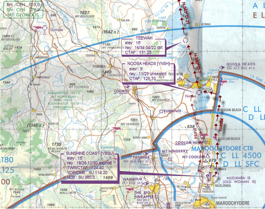
MAROOCHYDORE/SUNSHINE COAST [YBSU] Takeoff
elev : 15'
rwy : 18/26 12/30 asphalt
TWR/CTAF : 124.40
VOR/DME : SU 114.20
NDB : SU 380.0 -
NOOSA HEADS [YNSH] T&G - H-341° D-11
elev : 3'
rwy : 11/29 unsealed
CTAF : 126.70 -
TEEWAH T&G - H-340° D-7
elev : 15'
rwy : 16/34 04/22 dirt
CTAF : 131.25 -
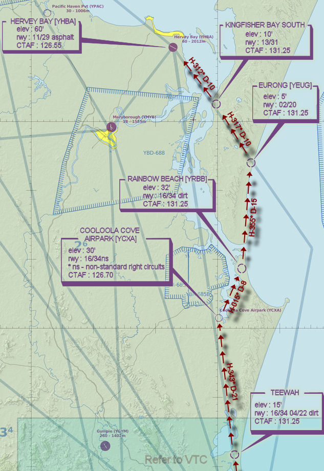
COOLOOLA COVE AIRPARK [YCXA] T&G - H-343° D-21
elev : 30'
rwy : 16/34ns
* ns - non-standard right circuits
CTAF : 126.70 -
RAINBOW BEACH [YRBB] T&G - H-015° D-8
elev : 32'
rwy : 16/34 dirt
CTAF : 131.25 -
EURONG [YEUG] T&G - H-355° D-15
elev : 5'
rwy : 02/20
CTAF : 131.25 -
KINGFISHER BAY SOUTH T&G - H-317° D-10
elev : 10'
rwy : 13/31
CTAF : 131.25 -
HERVEY BAY [YHBA] Land - H-312° D-10
elev : 60'
rwy : 11/29 asphalt
CTAF : 126.55
Sunshine Coast Departure VTC
Hervey Bay inbound WAN