Event created by Russell D - 1104622

Event Details
Simulation Date/Time : Current date set to daylight.
Weather : Real World / Fair weather if real world is unsuitable for VFR operations.
Distance : 187 nm
Est Flight Time : approx 85 mins
Aircraft : Twin engine aircraft such as a DC-3, DeHavilland DHC6 Twin Otter, Canadair CL-215, Grumman Goose or similar capable of 155 to 185 kias. Perfect opportunity to fly an amphibious aircraft.
Communications : Australia uses CTAF (Common Traffic Advisory Frequency) for radio comms at uncontrolled airfields. VATSIM pilots connecting to the network using FSCOPILOT/FSINN can install an additional file that provides the ability to tune the CTAF frequency and make voice announcements to other pilots on frequency. These files can be obtained via this link.
For pilots connecting to VATSIM using VPilot, there is a work around that enables these pilots to also take advantage of online voice CTAF. Refer to this informative VATPAC Forum post to learn how to implement the work around. Similarly, this work around has been reported to be successfully adopted for X-Plane using the X-Squawkbox client. As of yet there are no available instructions for doing this.
Altitude : Not above A9500
Flightplan
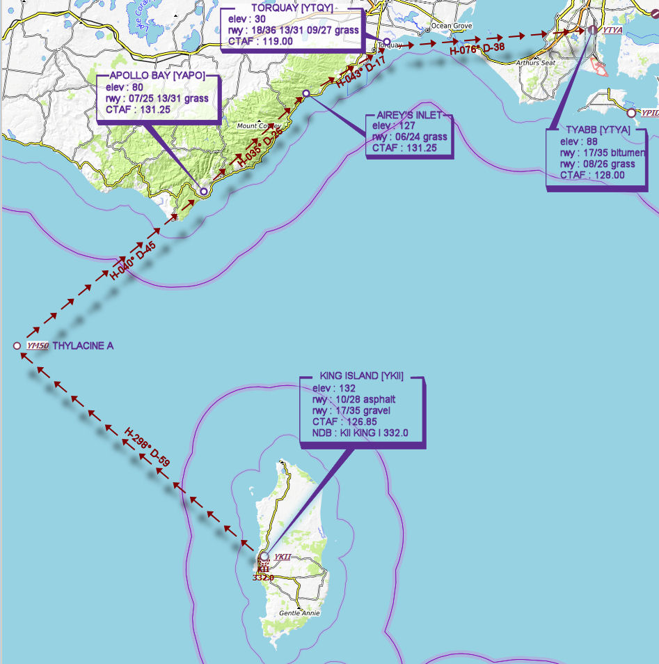
File as : YKII YM50 YAPO AIREY.INLET YTQY YTYA
GPS Flightplan is available for FSX and X-Plane FMS and also provided is the original Plan-G flightplan for those that find this useful all enclosed within a Zip archive.
Navigation : Pilots familiar with the area can navigate visually, for those less familiar the accompanying GPS Flightplan is the recommended method of navigating the flight plan.
Recommended Scenery
Flight Details
-
KING ISLAND [YKII] Takeoff
elev : 132
rwy : 10/28 asphalt
rwy : 17/35 gravel
CTAF : 126.85
NDB : KII KING I 332.0 -
THYLACINE A [YM50] Overfly - H-298° D-59.3 nm
-
APOLLO BAY [YAPO] T&G - H-040° D-44.9 nm
elev : 80
rwy : 07/25 13/31 grass
CTAF : 131.25 -
AIREY'S INLET T&G - H-035° D-26.4 nm
elev : 127
rwy : 06/24 grass
CTAF : 131.25 -
TORQUAY [YTQY] T&G - H-043° D-17.5 nm
elev : 30
rwy : 18/36 13/31 09/27 grass
CTAF : 119.00 -
TYABB [YTYA] Land - H-076° D-38.2 nm
elev : 88
rwy : 17/35 bitumen
rwy : 08/26 grass
CTAF : 128.00
Chart