Event created by Russell D - 1104622
Event Details
Simulation Date/Time : Current date set to daylight.
Weather : Real World / Fair weather if real world is unsuitable for VFR operations.
Distance :117 nm
Est Flight Time : approx 80 mins
Aircraft :Single engine aircraft such as Cessna 172 or similar capable of 105 to 125 kias.
Communications : Australia uses CTAF (Common Traffic Advisory Frequency) for radio comms at uncontrolled airfields. VATSIM pilots connecting to the network using FSCOPILOT/FSINN can install an additional file that provides the ability to tune the CTAF frequency and make voice announcements to other pilots on frequency. These files can be obtained via this link. For pilots connecting to VATSIM using VPilot, there is a work around that enables these pilots to also take advantage of online voice CTAF. Refer to this informative VATPAC Forum post to learn how to implement the work around. Similarly, this work around has been reported to be successfully adopted for X-Plane using the X-Squawkbox client. As of yet there are no available instructions for doing this.
Altitude : Below Adelaide Class C steps
Flightplan
File as : YPPF HVR WTC MLIT PNL SYN YSYN YMBD WARR DMW YPPF
GPS Flightplan is available for FSX and X-Plane FMS and also provided is the original Plan-G flightplan for those that find this useful all enclosed within a Zip archive.
Navigation : Pilots familiar with the area can navigate visually, for those less familiar the accompanying GPS Flightplan is the recommended method of navigating the flight plan.
Recommended Scenery
- YPPF Afcad to correct FSX default taxiway and runways
- ORBX Australia
- ANTS AUSSIE AIRPORTS
- OZX 3.5 AU Scenery
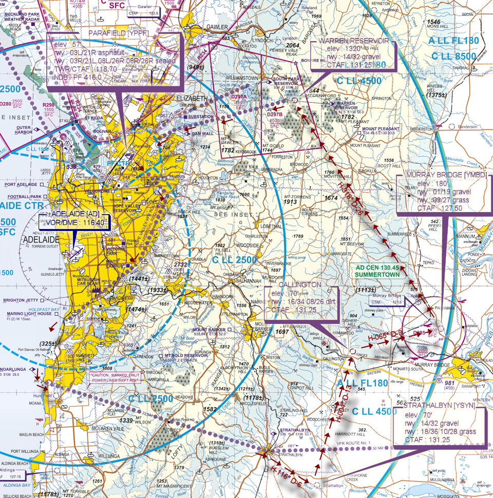
PARAFIELD PROCEDURES
Parafield is a general aviation class D aerodrome and is located in close proximity to Adelaide International Airport and RAAF Airbase Edinburgh. An excellent source of information for Parafield VFR operations inbound and outbound can be found in CASA's "Ontrack" Online Reference Resource. Pilots unfamiliar with Parafield Operations are encouraged to visit the site and review available information prior to operating within Parafield airspace.
Flight Details
PILOTS SHOULD ENSURE THEY SET THEIR TRANSPONDER TO MODE "C" (normal) AS THEY ENTER THE RUNWAY SO ATC WILL SEE AIRCRAFT ALTITUDE IN THEIR SCOPE
Navigation info - Adelaide VOR/DME : AD 116.40
-
PARAFIELD [YPPF] Takeoff
Pilots should set transponder to 3000 if ATC is active, 1200 otherwise
elev : 57'
rwy : 03L/21R asphault
rwy : 03R/21L 08L/26R 08R/26R sealed
TWR/CTAF : 118.70
NDB : PF 416.0
-
HOPE VALLEY RESERVOIR [HVR] Overfly - H-136° D-4
-
WAITE CAMPUS [WTC] Overfly - H-194° D-8
-
MARINO LIGHTHOUSE [MLIT] Overfly - H-218° D-8
-
PORT NOARLUNGA [PNL] Overfly - H-194° D-6
-
STRATHALBYN [SYN] Overfly - H-99° D-22
-
STRATHALBYN [YSYN] T&G - H-116° D-6
elev : 70'
rwy : 14/32 gravel
rwy : 18/36 10/28 grass
CTAF : 131.25
-
CALLINGTON T&G - H-004° D-13
elev : 70'
rwy : 16/34 08/26 dirt
CTAF : 131.25
-
MURRAY BRIDGE [YMBD] T&G - H-065° D-9
elev : 180'
rwy : 01/19 gravel
rwy : 09/27 grass
CTAF : 127.50
-
WARREN RESERVOIR T&G - H-318° D-26
elev : 1320'
rwy : 14/32 gravel
CTAF : 131.25
-
DAM WALL [DMW] Overfly - H-246° D-11
Pilots should set transponder to 3000 if ATC is active, 1200 otherwise
Inbound radio call for Parafield. IF TWR ACTIVE call PARAFIELD TOWER, [CALLSIGN][AIRCRAFT TYPE] DAM WALL 1500 RECEIVED INFORMATION [ATIS IDENTIFIER] INBOUND
-
PARAFIELD [YPPF] Land - H-235° D-5
Chart