Event created by Russell D - 1104622

Event Details
Welcome to 2019. This week VFR Operations commences the year in conjunction with VATPAC's focus month flying in South Australia. This flight traverses the Eyre Peninsula, the largest three SA peninsulas flying between Port Lincoln and Streaky Bay.
Simulation Date/Time : Current date set to daylight.
Weather : Real World / Fair weather if real world is unsuitable for VFR operations.
Distance : 212 nm
Est Flight Time : approx 90 mins
Aircraft : Single or twin engine aircraft such as Beechcraft Baron, Mooney Bravo or similar capable of 155 to 185 kias.
Communications : Australia uses CTAF (Common Traffic Advisory Frequency) for radio comms at uncontrolled airfields. VATSIM pilots connecting to the network using FSCOPILOT/FSINN can install an additional file that provides the ability to tune the CTAF frequency and make voice announcements to other pilots on frequency. These files can be obtained via this link.
For pilots connecting to VATSIM using VPilot, there is a work around that enables these pilots to also take advantage of online voice CTAF. Refer to this informative VATPAC Forum post to learn how to implement the work around.
Altitude : Not above FL125
Flightplan
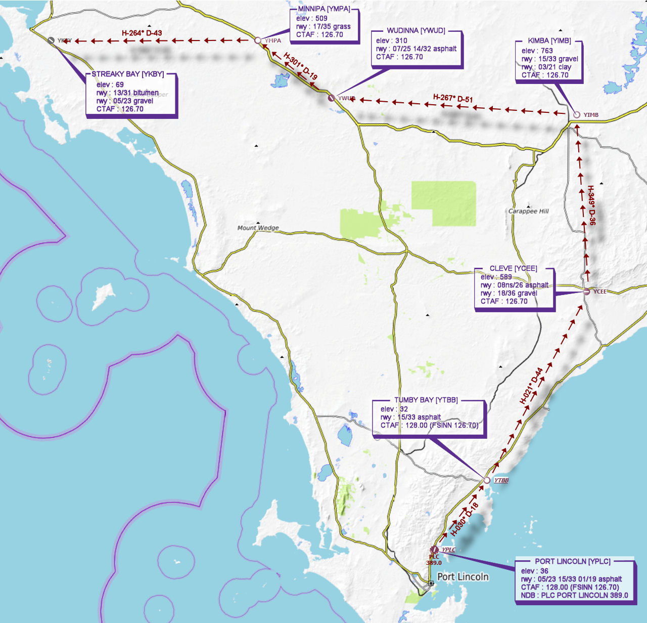
File as : YPLC YTBB YCEE YIMB YWUD YMPA YKBY
GPS Flightplan is available for FSX and X-Plane FMS and also provided is the original Plan-G flightplan for those that find this useful all enclosed within a Zip archive.
Navigation : Pilots familiar with the area can navigate visually, for those less familiar the accompanying GPS Flightplan is the recommended method of navigating the flight plan.
Recommended Scenery
Flight Details
-
PORT LINCOLN [YPLC] Takeoff
elev : 36
rwy : 05/23 15/33 01/19 asphalt
CTAF : 128.00 (FSINN 126.70)
NDB : PLC PORT LINCOLN 389.0 -
TUMBY BAY [YTBB] T&G - H-030° D-18.1 nm
elev : 32
rwy : 15/33 asphalt
CTAF : 128.00 (FSINN 126.70) -
CLEVE [YCEE] T&G - H-021° D-44.1 nm
elev : 589
rwy : 08ns/26 asphalt
rwy : 18/36 gravel
CTAF : 126.70 -
KIMBA [YIMB] T&G - H-349° D-36.7 nm
elev : 763
rwy : 15/33 gravel
rwy : 03/21 clay
CTAF : 126.70 -
WUDINNA [YWUD] T&G - H-267° D-51 nm
elev : 310
rwy : 07/25 14/32 asphalt
CTAF : 126.70 -
MINNIPA [YMPA] T&G - H-301° D-19.4 nm
elev : 509
rwy : 17/35 grass
CTAF : 126.70 -
STREAKY BAY [YKBY] Land - H-264° D-42.9 nm
elev : 69
rwy : 13/31 bitumen
rwy : 05/23 gravel
CTAF : 126.70
Chart