Event created by Russell D - 1104622

Event Details
Last month VFR Operations visited French New Caledonia, this week VFR Operations flies in the exotic South Pacific location of French Polynesia. This pair of flights flies between the airports of Faa'a and Maupiti visiting many of the airports located on the diverse spread of islands making up the region.
Simulation Date/Time : Current date set to daylight.
Weather : Real World / Fair weather if real world is unsuitable for VFR operations.
Distance : 250 nm
Est Flight Time : approx 85 mins
Aircraft : Single or twin engine high performance commuter aircraft such as Beechcraft King Air, Mitsubishi Solitaire or similar capable of 195 to 235 kias.
Communications : Tahiti uses standard unicom for radio comms at uncontrolled airfields. VATSIM pilots connecting to the network using FSCOPILOT/FSINN can install an additional file that provides the ability to tune the CTAF frequency and make voice announcements to other pilots on frequency. These files can be obtained via this link.
For pilots connecting to VATSIM using VPilot, there is a work around that enables these pilots to also take advantage of online voice CTAF. Refer to this informative VATPAC Forum post to learn how to implement the work around.
Altitude : Not above 9500
Flightplan
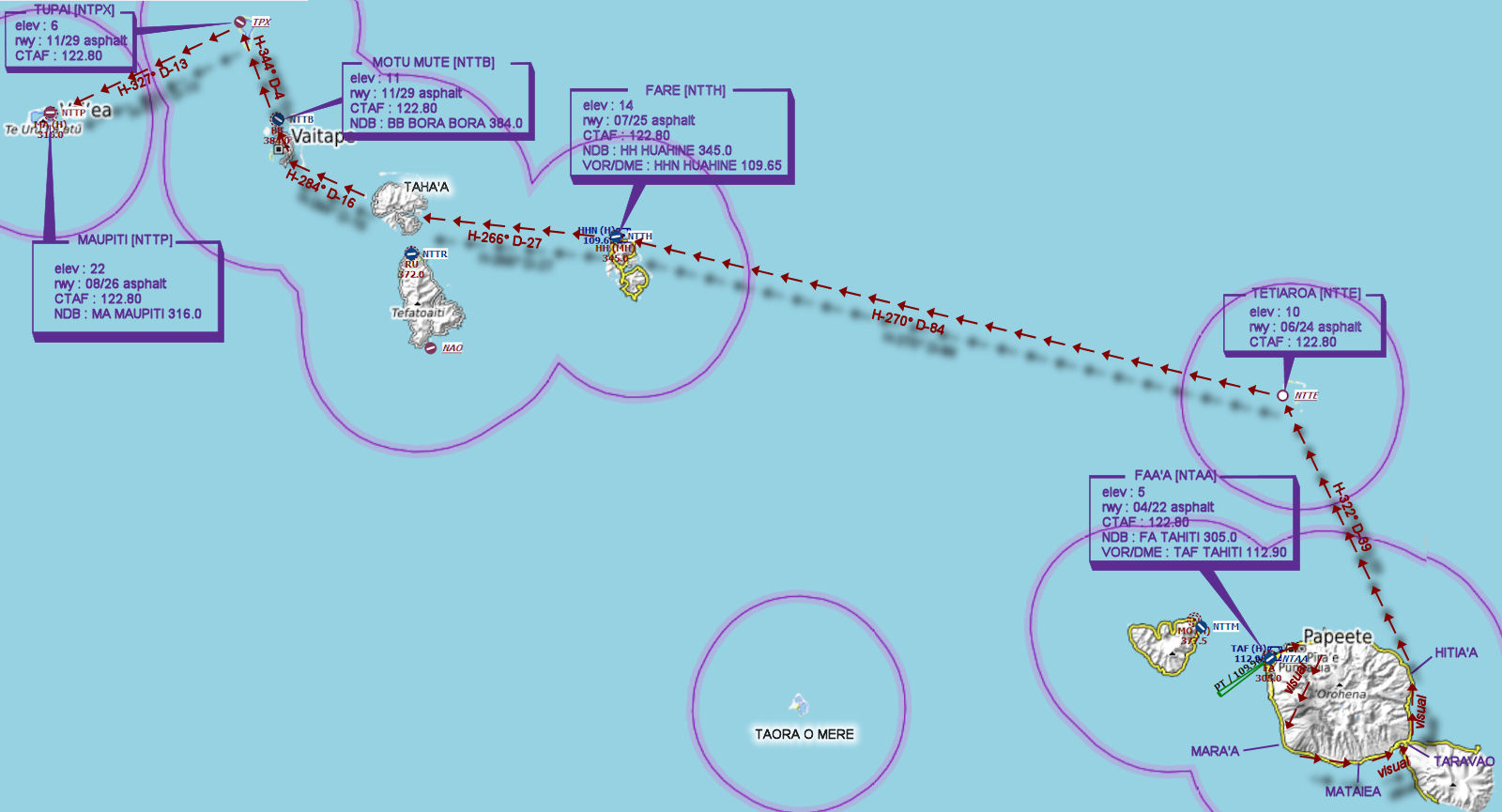
File as : NTAA NTTE NTTH NTTB NTPX NTTP
GPS Flightplan is available for FSX and X-Plane FMS and also provided is the original Plan-G flightplan for those that find this useful all enclosed within a Zip archive.
Navigation : Pilots familiar with the area can navigate visually, for those less familiar the accompanying GPS Flightplan is the recommended method of navigating the flight plan.
Recommended Scenery
- Aerosoft Tahiti-X (includes NTPX) or Default FSX/P3D
Flight Details
-
FAA'A [NTAA] Takeoff
elev : 5
rwy : 04/22 asphalt
CTAF : 122.80
NDB : FA TAHITI 305.0
VOR/DME : TAF TAHITI 112.90 -
PAPEETE Overfly - H-053° D-3.4 nm
-
MARA'A Overfly - H-172° D-12.6 nm
-
MATAIEA Overfly - H-088° D-9.6 nm
-
TARAVAO Overfly - H-051° D-6.1 nm
-
HITIA'A Overfly - H-339° D-7.6 nm
-
TETIAROA [NTTE] T&G - H-322° D-38.8 nm
elev : 10
rwy : 06/24 asphalt
CTAF : 122.80 -
FARE [NTTH] T&G - H-270° D-84.9 nm
elev : 14
rwy : 07/25 asphalt
CTAF : 122.80
NDB : HH HUAHINE 345.0
VOR/DME : HHN HUAHINE 109.65 -
TAHA'A Overfly - H-266° D-27.2 nm
-
VAITAPE Overfly - H-284° D-16.2 nm
-
MOTU MUTE [NTTB] T&G - H-344° D-3.8 nm
elev : 11
rwy : 11/29 asphalt
CTAF : 122.80
NDB : BB BORA BORA 384.0 -
TUPAI [NTPX] DEFAULT Overfly/Tahiti X T&G - H-327° D-13 nm
elev : 6
rwy : 11/29 asphalt
CTAF : 122.80 -
MAUPITI [NTTP] Land - H-233° D-26 nm
elev : 22
rwy : 08/26 asphalt
CTAF : 122.80
NDB : MA MAUPITI 316.0
Chart