Event created by Russell D - 1104622

Event Details
Simulation Date/Time : Current date set to daylight.
Weather : Real World / Fair weather if real world is unsuitable for VFR operations.
Distance : 160 nm
Est Flight Time : approx 80 mins
Aircraft : Single or twin engine aircraft such as Beechcraft Baron, Mooney Bravo or similar capable of 155 to 185 kias.
Communications : Australia uses CTAF (Common Traffic Advisory Frequency) for radio comms at uncontrolled airfields. VATSIM pilots connecting to the network using FSCOPILOT/FSINN can install an additional file that provides the ability to tune the CTAF frequency and make voice announcements to other pilots on frequency. These files can be obtained via this link.
For pilots connecting to VATSIM using VPilot, there is a work around that enables these pilots to also take advantage of online voice CTAF. Refer to this informative VATPAC Forum post to learn how to implement the work around.
Altitude : Below Perth Class C Steps
Flightplan
File as : YPJT YGB LTOM YSEN YDWG YCOI YNAU YMGT
GPS Flightplan is available for FSX and X-Plane FMS and also provided is the original Plan-G flightplan for those that find this useful all enclosed within a Zip archive.
Navigation : Pilots familiar with the area can navigate visually, for those less familiar the accompanying GPS Flightplan is the recommended method of navigating the flight plan.
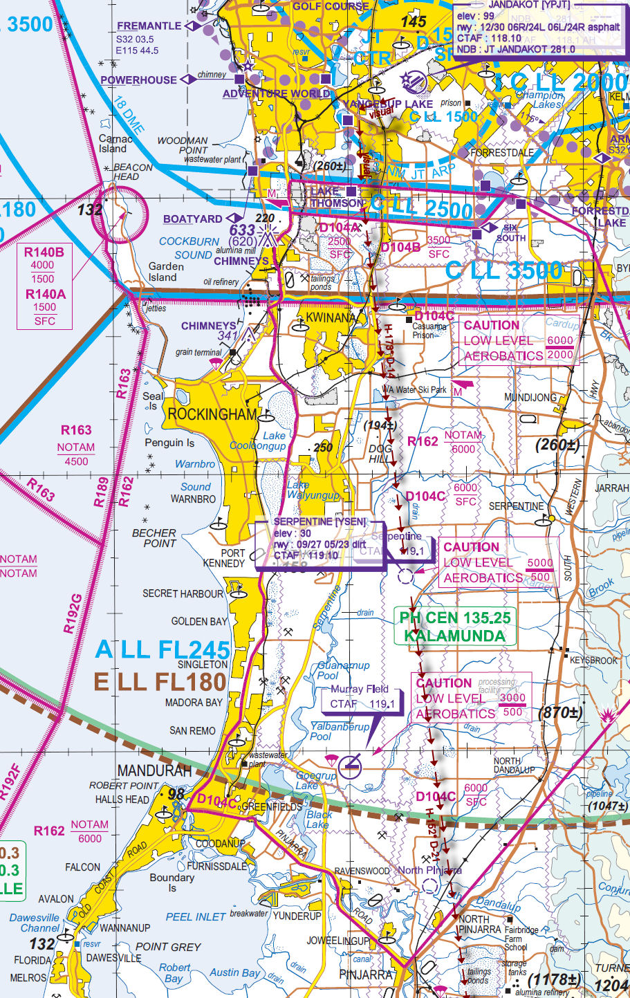
JANDAKOT PROCEDURES
Jandakot is a general aviation class D aerodrome and is located in close proximity to Perth International Airport and RAAF Airbase Pearce. An excellent source of information for Jandakot VFR operations inbound and outbound can be found in CASA's "Ontrack" Online Reference Resource. Pilots unfamiliar with Jandakot Operations are encouraged to visit the site and review available information prior to operating within Jandakot airspace.In particular, review; Jandakot
- Outbound to the South
Recommended Scenery
- ORBX Perth Jandakot [YPJT]
- Alan Blencowe - Serpentine YSEN
- ORBX Australia
- ANTS AUSSIE AIRPORTS
- OZX AU Scenery
Flight Details
-
JANDAKOT [YPJT] Takeoff
elev : 99
rwy : 12/30 06R/24L 06L/24R asphalt
CTAF : 118.10
NDB : JT JANDAKOT 281.0 -
YANGEBUP LAKE [YGB] Overfly - H-243° D-2.8 nm
-
LAKE THOMSON [LTOM] Overfly - H-177° D-1.9 nm
-
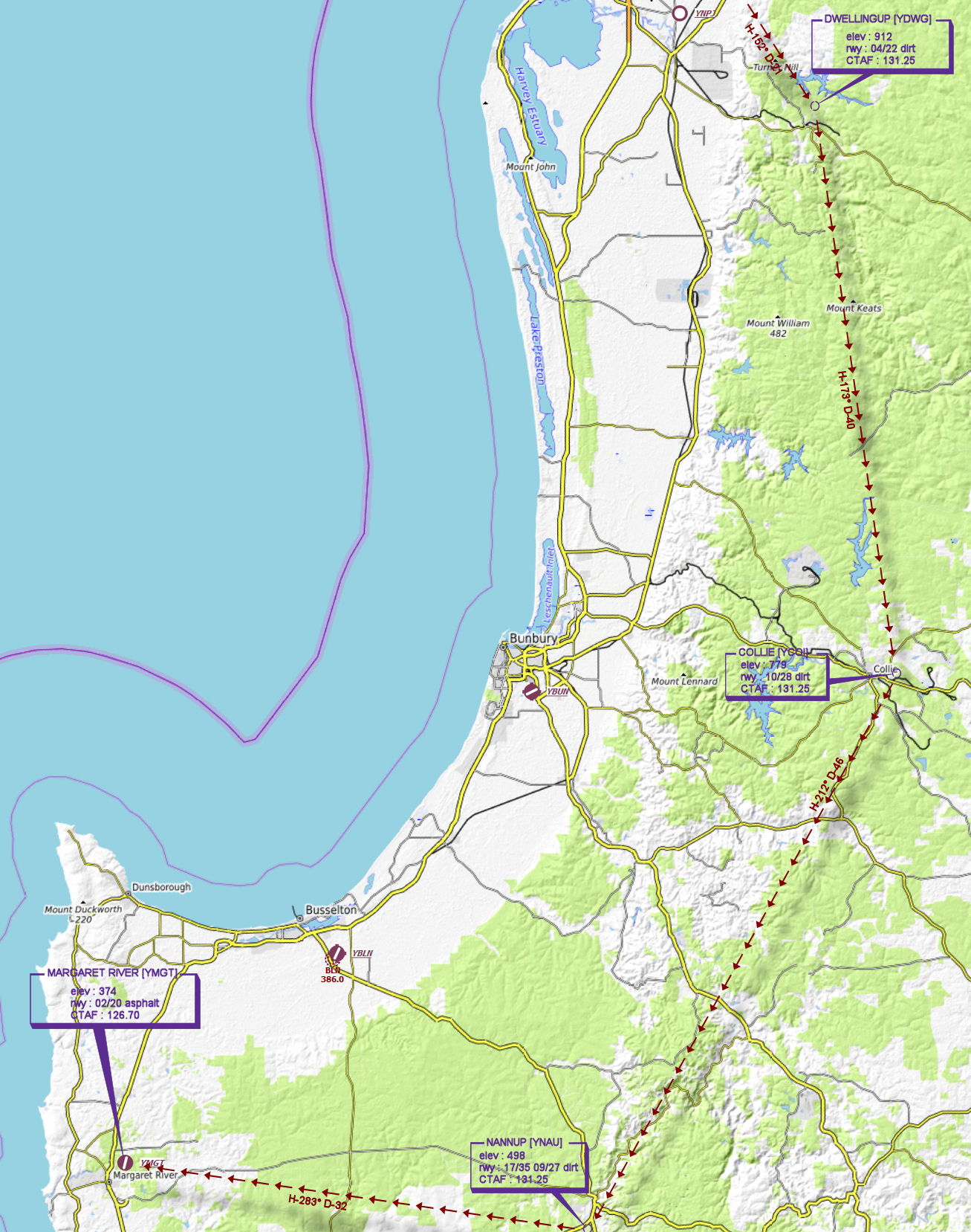
SERPENTINE [YSEN] T&G - H-173° D-14.7 nm
elev : 30
rwy : 09/27 05/23 dirt
CTAF : 119.10 -
DWELLINGUP [YDWG] T&G - H-152° D-20.6 nm
elev : 912
rwy : 04/22 dirt
CTAF : 131.25 -
COLLIE [YCOI] T&G - H-173° D-40.5 nm
elev : 779
rwy : 10/28 dirt
CTAF : 131.25 -
NANNUP [YNAU] T&G - H-212° D-46.5 nm
elev : 498
rwy : 17/35 09/27 dirt
CTAF : 131.25 -
MARGARET RIVER [YMGT] Land - H-283° D-32.3 nm
elev : 374
rwy : 02/20 asphalt
CTAF : 126.70
VTC Chart
WAN Chart