Event created by Russell D - 1104622

Event Details
This week VFR Operations leaves Australia and Jumps the Ditch to fly the islands of New Caledonia. The flight provides a great introduction to the airspace in anticipation of the Summer 2018 Cross the Ditch.
Simulation Date/Time : Current date set to daylight.
Weather : Real World / Fair weather if real world is unsuitable for VFR operations.
Distance : 225 nm
Est Flight Time : approx 85 mins
Aircraft : Twin engine aircraft such as Douglas DC-3, Aero Commander 560 or similar capable of 165 to 2055 kias.
Communications : For those using FSINN or AVS voice communications can be made on 122.80 or "rw1.vatpac.org/UNICOM_NFFF"/"rw1.vatpac.org/UNICOM_AU". VATSIM pilots connecting to the network using FSCOPILOT/FSINN can install an additional file that provides the ability to tune the CTAF frequency and make voice announcements to other pilots on frequency. These files can be obtained via this link.
For pilots connecting to VATSIM using VPilot, there is a work around that enables these pilots to also take advantage of online voice CTAF. Refer to this informative VATPAC Forum post to learn how to implement the work around.
Altitude : Not above 8500
Flightplan
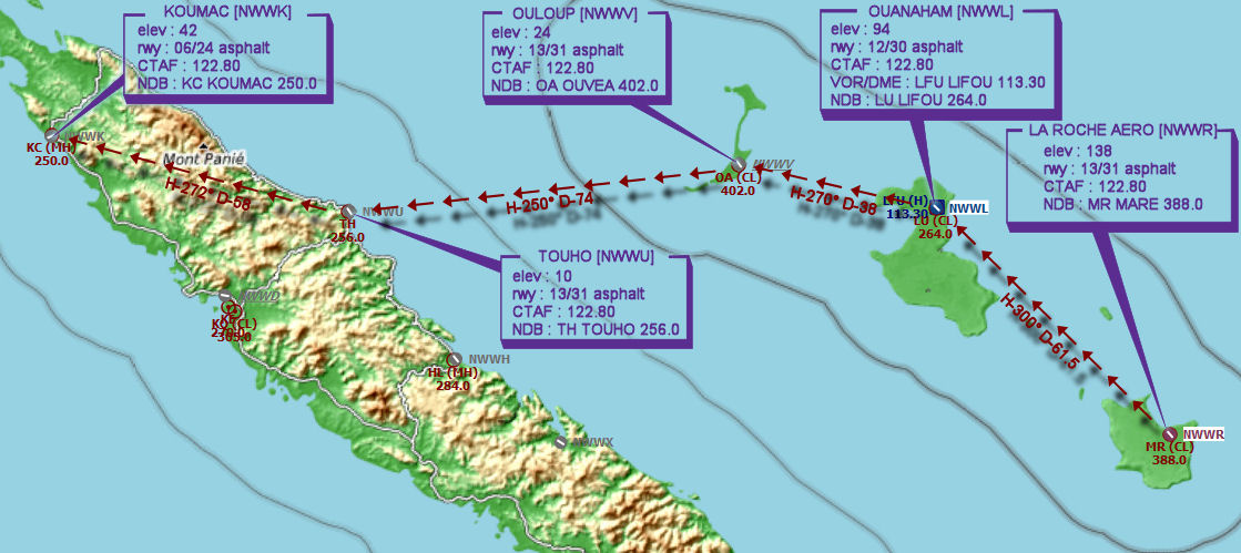
File as : NWWR NWWL NWWV NWWU NWWK
GPS Flightplan is available for FSX and X-Plane FMS and also provided is the original Plan-G flightplan for those that find this useful all enclosed within a Zip archive.
Navigation : Pilots familiar with the area can navigate visually, for those less familiar the accompanying GPS Flightplan is the recommended method of navigating the flight plan.
Recommended Scenery
Flight Details
-
LA ROCHE AERO [NWWR] Takeoff
elev : 138
rwy : 13/31 asphalt
CTAF : 122.80
NDB : MR MARE 388.0 -
OUANAHAM [NWWL] T&G - H-300° D-61.6 nm
elev : 94
rwy : 12/30 asphalt
CTAF : 122.80
VOR/DME : LFU LIFOU 113.30
NDB : LU LIFOU 264.0 -
OULOUP [NWWV] T&G - H-270° D-38.3 nm
elev : 24
rwy : 13/31 asphalt
CTAF : 122.80
NDB : OA OUVEA 402.0 -
TOUHO [NWWU] T&G - H-250° D-74.3 nm
elev : 10
rwy : 13/31 asphalt
CTAF : 122.80
NDB : TH TOUHO 256.0 -
KOUMAC [NWWK] Land - H-272° D-58.2 nm
elev : 42
rwy : 06/24 asphalt
CTAF : 122.80
NDB : KC KOUMAC 250.0
Chart