Event created by Russell D - 1104622

Event Details
Flight created by Russell Diehl
This week we join up with the Formula One Circus at the Yas Marina Circuit in Abu Dhabi for the final race for the 2018 season.
Simulation Date/Time : Current date set to daylight.
Weather : Real World / Fair weather if real world is unsuitable for VFR operations.
Distance : 145 nm
Est Flight Time : approx 80 mins
Aircraft : A single or twin piston engine aircraft such as Mooney Bravo, Beechcraft Baron or similar capable of 155 to 175 kias.
Communications : Unicom "rw1.vatpac.org/UNICOM_OMAE" for the Sirri Island Region. VATSIM pilots connecting to the network using FSCOPILOT/FSINN can install an additional file that provides the ability to tune the CTAF frequency and make voice announcements to other pilots on frequency. These files can be obtained via this link.
For pilots connecting to VATSIM using VPilot, there is a work around that enables these pilots to also take advantage of online voice CTAF. Refer to this informative VATPAC Forum post to learn how to implement the work around.
Altitude : 3500 recommended
Flightplan
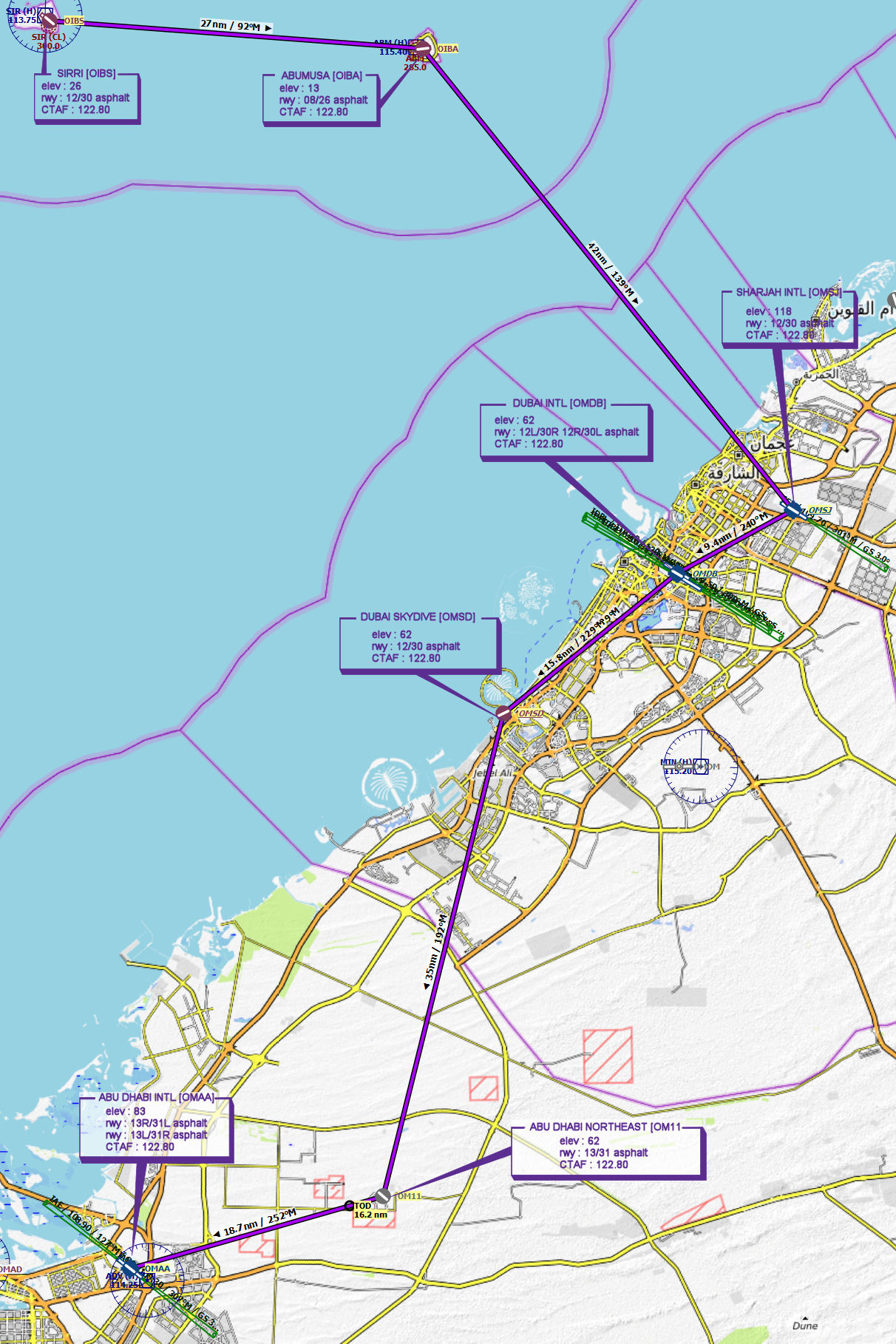
File as : OIBS OIBA OMSJ OMDB OMSD OM11 OMAA
GPS Flightplan is available for FSX and X-Plane FMS and also provided is the original Plan-G flightplan for those that find this useful all enclosed within a Zip archive.
Navigation : The accompanying GPS Flightplan is the recommended method of navigating the flight plan however it should be possible to navigate visually given the islands proximity to the main land.
Recommended Scenery
- optional (Recommended) - Fly Tampa Dubai Intl includes surrounding area
- Default simulation scenery
Flight Details
-
SIRRI [OIBS] Takeoff
elev : 26
rwy : 12/30 asphalt
CTAF : 122.80 -
ABUMUSA [OIBA] T&G - H-093° D-26.5 nm
elev : 13
rwy : 08/26 asphalt
CTAF : 122.80 -
SHARJAH INTL [OMSJ] T&G - H-140° D-42 nm
elev : 118
rwy : 12/30 asphalt
CTAF : 122.80 -
DUBAI INTL [OMDB] T&G - H-240° D-9.4 nm
elev : 62
rwy : 12L/30R 12R/30L asphalt
CTAF : 122.80 -
DUBAI SKYDIVE [OMSD] T&G - H-229° D-15.8 nm
elev : 62
rwy : 12/30 asphalt
CTAF : 122.80 -
ABU DHABI NORTHEAST [OM11] T&G - H-193° D-35.3 nm
elev : 62
rwy : 13/31 asphalt
CTAF : 122.80 -
ABU DHABI INTL [OMAA] Land - H-253° D-18.7 nm
elev : 83
rwy : 13R/31L asphalt
rwy : 13L/31R asphalt (MAY NOT BE DEPICTED IN SOME DEFAULT FSX INSTALLATIONS)
CTAF : 122.80
Chart