Event created by Russell D - 1104622

Event Details
Simulation Date/Time : Current date set to daylight.
Weather : Real World / Fair weather if real world is unsuitable for VFR operations.
Distance : 175 nm
Est Flight Time : approx 80 mins
Aircraft : Single or twin engine aircraft such as Beechcraft Baron, Mooney Bravo or similar capable of 155 to 185 kias.
Communications : Australia uses CTAF (Common Traffic Advisory Frequency) for radio comms at uncontrolled airfields. VATSIM pilots connecting to the network using FSCOPILOT/FSINN can install an additional file that provides the ability to tune the CTAF frequency and make voice announcements to other pilots on frequency. These files can be obtained via this link.
For pilots connecting to VATSIM using VPilot, there is a work around that enables these pilots to also take advantage of online voice CTAF. Refer to this informative VATPAC Forum post to learn how to implement the work around.
Altitude : Not above FL125
Flightplan
File as : YKIG YRBE YMCT YMTG YPOD YWBL
GPS Flightplan is available for FSX and X-Plane FMS and also provided is the original Plan-G flightplan for those that find this useful all enclosed within a Zip archive.
Navigation : Pilots familiar with the area can navigate visually, for those less familiar the accompanying GPS Flightplan is the recommended method of navigating the flight plan.
Recommended Scenery
- Warrnambool Airport YWBL - Colin Jeffery
- Portland YPOD - Colin Jeffery
- ORBX Australia
- ANTS AUSSIE AIRPORTS
- OZX AU Scenery
Flight Details
-
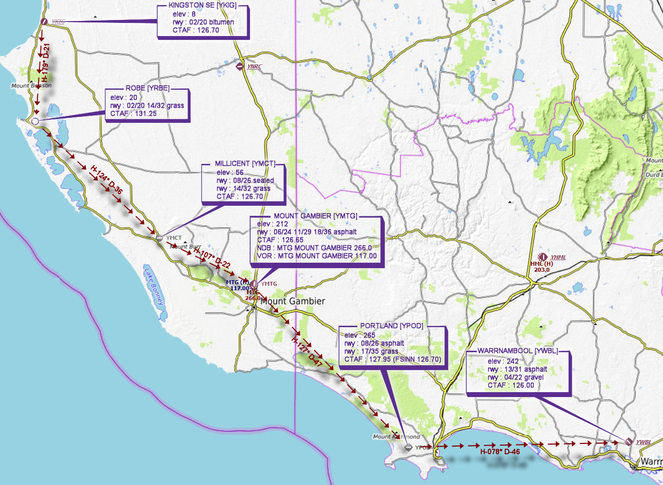
KINGSTON SE [YKIG] Takeoff
elev : 8
rwy : 02/20 bitumen
CTAF : 126.70 -
ROBE [YRBE] T&G - H-179° D-21.4 nm
elev : 20
rwy : 02/20 14/32 grass
CTAF : 131.25 -
MILLICENT [YMCT] T&G - H-124° D-36.3 nm
elev : 56
rwy : 08/26 sealed
rwy : 14/32 grass
CTAF : 126.70 -
MOUNT GAMBIER [YMTG] T&G - H-107° D-22.2 nm
elev : 212
rwy : 06/24 11/29 18/36 asphalt
CTAF : 126.65
NDB : MTG MOUNT GAMBIER 266.0
VOR : MTG MOUNT GAMBIER 117.00 -
PORTLAND [YPOD] T&G - H-127° D-47.2 nm
elev : 265
rwy : 08/26 asphalt
rwy : 17/35 grass
CTAF : 127.95 (FSINN 126.70) -
WARRNAMBOOL [YWBL] Land - H-078° D-46.3 nm
elev : 242
rwy : 13/31 asphalt
rwy : 04/22 gravel
CTAF : 126.00
Chart