Event created by Russell D - 1104622

Event Details
Simulation Date/Time : Current date set to daylight.
Weather : Real World / Fair weather if real world is unsuitable for VFR operations.
Distance : 285 nm
Est Flight Time : approx 90 mins
Aircraft : Single or twin engine turboprop aircraft such as Pilatus PC-12, Beechcraft King Air, Mitsubishi Solitaire, Lancair Legacy or similar capable of 225 to 255 kias.
Communications : Australia uses CTAF (Common Traffic Advisory Frequency) for radio comms at uncontrolled airfields. VATSIM pilots connecting to the network using FSCOPILOT/FSINN can install an additional file that provides the ability to tune the CTAF frequency and make voice announcements to other pilots on frequency. These files can be obtained via this link.
Altitude : Not above FL125
Flightplan
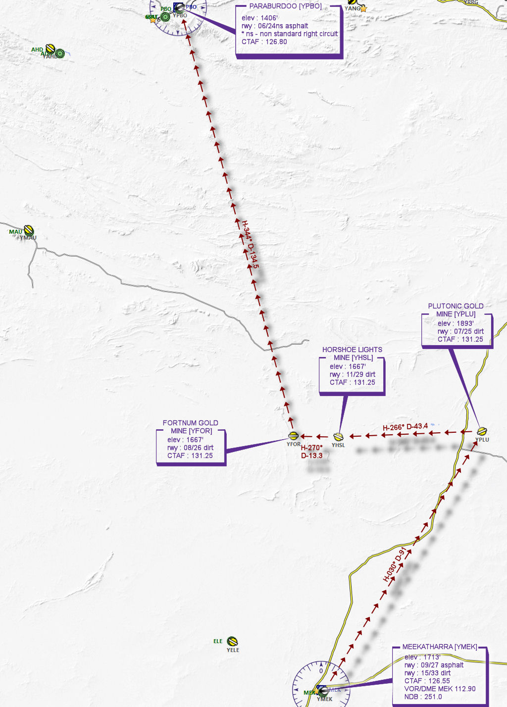
File as : YMEK YPLU YHSL YFOR YPBO
GPS Flightplan is available for FSX and X-Plane FMS and also provided is the original Plan-G flightplan for those that find this useful all enclosed within a Zip archive.
Navigation : Pilots familiar with the area can navigate visually, for those less familiar the accompanying GPS Flightplan is the recommended method of navigating the flight plan.
Recommended Scenery
- Alan Blencowe - Plutonic Mine YPLU
- Alan Blencowe - Horseshoe Lights Mine
- Alan Blencowe - Fortnum Gold Mine YFOR
- ORBX Australia
- ANTS AUSSIE AIRPORTS
- OZX AU Scenery
Flight Details
-
MEEKATHARRA [YMEK] Takeoff
elev : 1713'
rwy : 09/27 asphalt
rwy : 15/33 dirt
CTAF : 126.55
VOR/DME MEK 112.90
NDB : 251.0 -
PLUTONIC GOLD MINE [YPLU] T&G - H-030° D-90.9 nm
elev : 1893'
rwy : 07/25 dirt
CTAF : 131.25 -
HORSHOE LIGHTS MINE [YHSL] T&G - H-266° D-43.4 nm
elev : 1667'
rwy : 11/29 dirt
CTAF : 131.25 -
FORTNUM GOLD MINE [YFOR] T&G - H-270° D-13.3 nm
elev : 1667'
rwy : 08/26 dirt
CTAF : 131.25 -
PARABURDOO [YPBO] Land - H-344° D-134.5 nm
elev : 1406'
rwy : 06/24ns asphalt
* ns - non standard right circuit
CTAF : 126.80
Chart