Event created by Russell D - 1104622

Event Details
Flight created by Russell Diehl
This week we from the Atlantic Ocean to the Pacific Ocean via the Panama canal. There is a link to some accompanying scenery enhancements for the flight if so desired. This represents a slow short flight and is an opportunity to undertake the flight in a slow recreational/sports aircraft.
Simulation Date/Time : Current date set to daylight.
Weather : Real World / Fair weather if real world is unsuitable for VFR operations.
Distance : 76 nm
Est Flight Time : approx 80 mins
Aircraft : A light recreational sport such as J-3 Piper Cub, A-22 Foxbat or similar incapable of exceeding 100 knots. Alternatively a helicopter such as the Robison R22 can be used to add flexibility
Communications : Unicom "rw1.vatpac.org/UNICOM_MPZL" for the Panama Region. VATSIM pilots connecting to the network using FSCOPILOT/FSINN can install an additional file that provides the ability to tune the CTAF frequency and make voice announcements to other pilots on frequency. These files can be obtained via this link.
For pilots connecting to VATSIM using VPilot, there is a work around that enables these pilots to also take advantage of online voice CTAF. Refer to this informative VATPAC Forum post to learn how to implement the work around.
Altitude : 1500 recommended
Flightplan
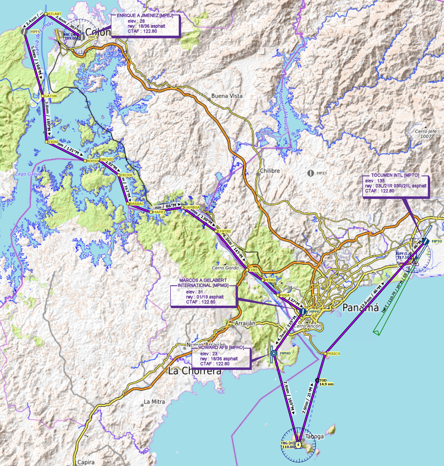
File as : MPEJ ATLANT MPFS GATUN TRINI BOHIO ORCHID FRIJOL BARBAC MAMEI GAMBOA EMPIRE CENT PEDRO MIRA MPMG MPHO TBG PERICO MPTO
GPS Flightplan is available for FSX and X-Plane FMS and also provided is the original Plan-G flightplan for those that find this useful all enclosed within a Zip archive.
Navigation : The accompanying GPS Flightplan is the recommended method of navigating the flight plan however it should be possible to navigate visually and may be the only option given the low sophistication of the recommended aircraft types.
Recommended Scenery
- optional (Recommended) - Compilation of 3 small scenery packages covering the departure and arrival airport as well as the canal (30 MB download)
- Default simulation scenery
Flight Details
-
ENRIQUE A JIMENEZ [MPEJ] Takeoff
elev : 28
rwy : 18/36 asphalt
CTAF : 122.80 -
ATLANTIC ENTRANCE [ATLANT] Overfly - H-304° D-3.6 nm
-
SHERMAN [MPFS] Overfly - H-233° D-2.3 nm
-
GATUN LOCKS [GATUN] Overfly - H-165° D-5.6 nm
-
TRINIDAD TURN [TRINI] Overfly - H-178° D-3.8 nm
-
BOHIO TURN [BOHIO] Overfly - H-119° D-3.6 nm
-
ORCHID TURN [ORCHID] Overfly - H-086° D-1.1 nm
-
FRIJOLES TURN [FRIJOL] Overfly - H-130° D-2.1 nm
-
BARBACOA TURN [BARBAC] Overfly - H-165° D-2.5 nm
-
MAMEI TURN [MAMEI] Overfly - H-112° D-2.1 nm
-
GAMBOA REACH [GAMBOA] Overfly - H-084° D-2.7 nm
-
EMPIRE REACH [EMPIRE] Overfly - H-128° D-3.4 nm
-
CENTENNIAL BRIDGE [CENT] Overfly - H-143° D-4.2 nm
-
PEDRO MIGUEL LOCKS [PEDRO] Overfly - H-127° D-1.6 nm
-
MIRO FLORES LOCK [MIRA] Overfly - H-138° D-1.8 nm
-
MARCOS A GELABERT INTL [MPMG] T&G - H-125° D-2.5 nm
elev : 31
rwy : 01/19 asphalt
CTAF : 122.80 -
HOWARD AFB [MPHO] T&G - H-216° D-4.3 nm
elev : 23
rwy : 18/36 asphalt
CTAF : 122.80 -
TABOGA ISLAND (110 MHZ) [TBG] Overfly - H-167° D-7.9 nm
-
ISLA PERICO [PERICO] Overfly - H-018° D-7.9 nm
-
TOCUMEN INTL [MPTO] Land - H-044° D-12.6 nm
elev : 135
rwy : 03L/21R 03R/21L asphalt
CTAF : 122.80
Chart