Event created by Russell D - 1104622

Event Details
Simulation Date/Time : Current date set to daylight.
Weather : Real World / Fair weather if real world is unsuitable for VFR operations.
Distance : 187 nm
Est Flight Time : approx 80 mins
Aircraft : Single or twin turbine engine aircraft such as Beechcraft King Air, Pilatus PC-12 or similar capable of 175 to 225 kias.
Communications : New Zealand uses CTAF (Common Traffic Advisory Frequency) for radio comms at uncontrolled airfields however there are no resources to support individual frequencies as such the use of voice unicom 122.80 is recommended. VATSIM pilots connecting to the network using FSCOPILOT/FSINN can install an additional file that provides the ability to tune the CTAF frequency and make voice announcements to other pilots on frequency. These files can be obtained via this link.
For pilots connecting to VATSIM using VPilot, there is a work around that enables these pilots to also take advantage of online voice CTAF. Refer to this informative VATPAC Forum post to learn how to implement the work around.
Altitude : Not above FL125
Flightplan
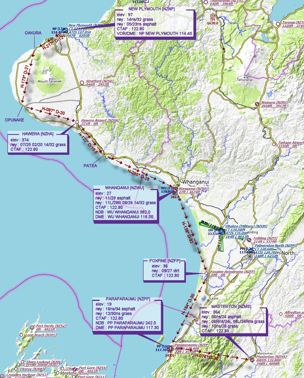
File as : NZNP OAKURA OPUNAKE NZHA PATEA NZWU NZFP NZPP NZMS
GPS Flightplan is available for FSX and X-Plane FMS and also provided is the original Plan-G flightplan for those that find this useful all enclosed within a Zip archive.
Navigation : Pilots familiar with the area can navigate visually, for those less familiar the accompanying GPS Flightplan is the recommended method of navigating the flight plan.
Recommended Scenery
- New Plymouth NZNP (FSX)
- ORBX New Zealand North Island (includes most NZNI airports)
- ANTS AUSSIE AIRPORTS
- OZX AU Scenery
Flight Details
-
NEW PLYMOUTH [NZNP] Takeoff
elev : 97
rwy : 14/32ns grass
rwy : 05/23ns asphalt
CTAF : 122.80
VOR/DME : NP NEW PLYMOUTH 114.40 -
OAKURA Overfly - H-217° D-12 nm
-
OPUNAKE Overfly - H-173° D-20.9 nm
-
HAWERA [NZHA] T&G - H-087° D-20.1 nm
elev : 374
rwy : 07/25 02/20 14/32 grass
CTAF : 122.80 -
PATEA Overfly - H-122° D-15.5 nm
-
WHANGANUI [NZWU] T&G - H-095° D-28.1 nm
elev : 27
rwy : 11/29 asphalt
rwy : 11L/29R 08/26 14/32 grass
CTAF : 122.80
NDB : WU WHANGANUI 382.0
DME : WU WHANGANUI 116.00 -
FOXPINE [NZFP] T&G - H-138° D-31.7 nm
elev : 36
rwy : 09/27 dirt
CTAF : 122.80 -
PARAPARAUMU [NZPP] T&G - H-184° D-29.8 nm
elev : 19
rwy : 16ns/34 asphalt
rwy : 12/30ns grass
CTAF : 122.80
NDB : PP PARAPARAUMU 242.0
DME : PP PARAPARAUMU 117.30 -
MASTERTON [NZMS] Land - H-076° D-29.5 nm
elev : 364
rwy : 06ns/24 asphalt
rwy : 06Rns/24L 06L/24Rns 10ns/28 grass
CTAF : 122.80
Chart