Event created by Russell D - 1104622

Event Details
Simulation Date/Time : Current date set to daylight.
Weather : Real World / Fair weather if real world is unsuitable for VFR operations.
Distance : 161 nm
Est Flight Time : approx 80 mins
Aircraft : Single or twin engine aircraft such as Beechcraft Baron, Mooney Bravo or similar capable of 155 to 185 kias.
Communications : Australia uses CTAF (Common Traffic Advisory Frequency) for radio comms at uncontrolled airfields. VATSIM pilots connecting to the network using FSCOPILOT/FSINN can install an additional file that provides the ability to tune the CTAF frequency and make voice announcements to other pilots on frequency. These files can be obtained via this link.
For pilots connecting to VATSIM using VPilot, there is a work around that enables these pilots to also take advantage of online voice CTAF. Refer to this informative VATPAC Forum post to learn how to implement the work around.
Altitude : Below Darwin Class C steps
Flightplan
File as : YPKT PERON DUNDEE YDII CRAB.CLAW YDLV CHAP YPDN
GPS Flightplan is available for FSX and X-Plane FMS and also provided is the original Plan-G flightplan for those that find this useful all enclosed within a Zip archive.
Navigation : Pilots have a choice of alternatives for this flight. There is the obligatory accompanying flight plan for those that embrace the latest technology. For the more adventurous pilots the radial and distances are provided allowing the flight to be navigated using ground based radio and visual navigation techniques.
DARWIN PROCEDURES
Darwin is a class C civil and military aerodrome. An excellent source of VFR procedural information for Darwin can be found in CASA's "Ontrack" Online Reference Resource. Pilots unfamiliar with Darwin Operations are encouraged to visit the site and review available information (video is very informative) prior to operating within Darwin airspace.
In this flight a non standard arrival not depicted as an option is used.
Recommended Scenery
Flight Details
-
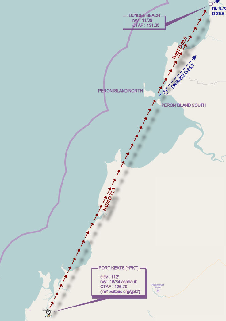
PORT KEATS [YPKT] Takeoff
elev : 112
rwy : 16/34 asphalt
CTAF : 126.70 -
PERON ISLANDS Overfly - H-024° D-71.3 nm
pos : DN R-222° D-66.5 -
DUNDEE BEACH T&G - H-027° D-32.5 nm
pos : DN R-237° D-36.5
elev : 3
rwy : 11/29 sand
CTAF : 131.25 -
DUM IN MIRRIE IS [YDII] T&G - H-002° D-5.4 nm
pos : DN R-244° D-32.6
elev : 19
rwy : 15/33 dirt
CTAF : 131.25 -
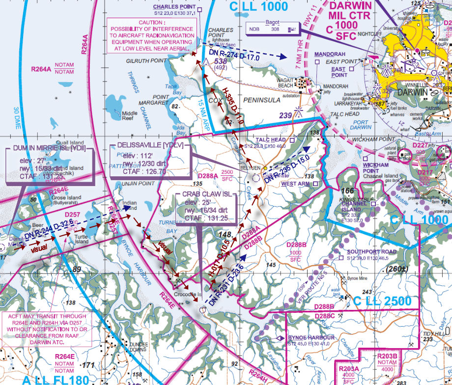
CRAB CLAW ISLAND T&G - H-106° D-15.5 nm
pos : DN R-231° D-23.6
elev : 5
rwy : 16/34 dirt
CTAF : 131.25 -
DELISSAVILLE [YDLV] T&G - H-017° D-10.5 nm
pos : DN R-235° D-15
elev : 112
rwy : 12ns/30 dirt
CTAF : 126.70 -
CHARLES POINT [CHAP] Overfly - H-335° D-10.8 nm * caution DN A1000 step
pos : DN R-274° D-17.0 -
DARWIN INTL [YPDN] Land - H-093° D-15.3 nm
elev : 103
rwy : 18/36 11/29 asphalt
CTAF : 122.80
NDB : BGT BAGOT DARWIN 308.0
TACAN : DAR DARWIN 113.70
VOR/DME : DN DARWIN 112.60
WAN Chart
VTC Chart