Event created by Russell D - 1104622

Event Details
Flight created by Russell Diehl
This week we fly Chuuk (formerly Truk) Lagoon in Micronesia, a site used by the Japanese Navy in WWII where numerous ships were sunk in allied attacks. The remaining wrecks provide highly popular under water dive locations. Pilots are encouraged to download and install the additional scenery. Doing this will depict the lagoon as it existed in 1945. This replaces the present day international airport with a Japanese bomber aerodrome and adds shipping and two additional small fighter airstrips. Whilst this is encouraged, the flight can be enjoyed with default scenery though will lack the shipping and additional airfields.
Simulation Date/Time : Current date set to daylight.
Weather : Real World / Fair weather if real world is unsuitable for VFR operations.
Distance : 100 nm
Est Flight Time : approx 60 mins
Aircraft : Vintage twin piston engine aircraft such as Douglas DC-3, Grumman Goose or similar capable of 135 to 155 kias.
Communications : Unicom "rw1.vatpac.org/UNICOM_KZAK" for Micronesian Region. VATSIM pilots connecting to the network using FSCOPILOT/FSINN can install an additional file that provides the ability to tune the CTAF frequency and make voice announcements to other pilots on frequency. These files can be obtained via this link.
For pilots connecting to VATSIM using VPilot, there is a work around that enables these pilots to also take advantage of online voice CTAF. Refer to this informative VATPAC Forum post to learn how to implement the work around.
Altitude : 2500 recommended
Flightplan
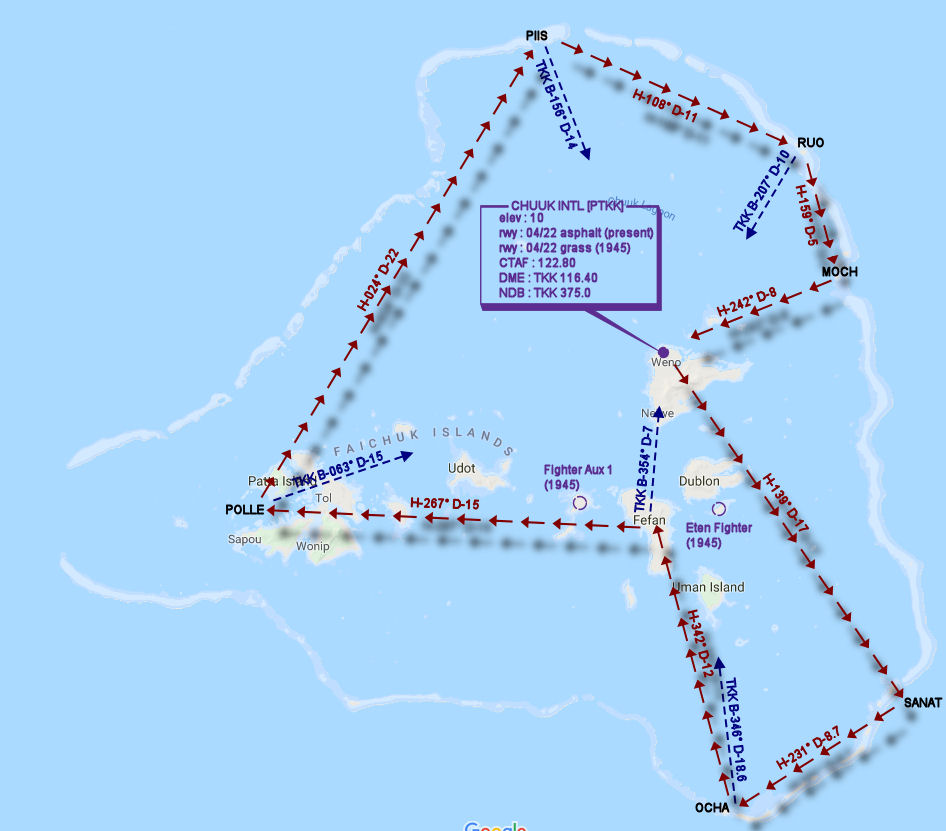
File as : PTKK SANAT OCHA FEFAN POLLE PIIS RUO MOCH PTKK
GPS Flightplan is available for FSX and X-Plane FMS and also provided is the original Plan-G flightplan for those that find this useful all enclosed within a Zip archive.
Navigation : The accompanying GPS Flightplan is the recommended method of navigating the flight plan however it should be possible to navigate visually and may be the only option given the age of the recommended aircraft types.
Recommended Scenery
- Highly recommended - WWII eras Truk Atoll including Japanese Naval and Air bases.
- Default simulation scenery should be adequate in lieu of the above. Defaults to PTKK Chuuk International airport
Flight Details
-
CHUUK INTL [PTKK] Takeoff
elev : 10
rwy : 04/22 asphalt
CTAF : 122.80
DME : TKK 116.40
NDB : TKK 375.0 -
SANAT Isl Overfly - H-139° D-16.9 nm
pos : TKK B-316° D-16.5 -
OCHA Isl Overfly - H-231° D-8.7 nm
pos : TKK B-346° D-18.6 -
FEFAN Isl Overfly - H-342° D-12.2 nm
pos : TKK B-354° D-7.0 -
POLLE Overfly - H-267° D-14.9 nm
pos : TKK B-063° D-15.0 -
PIIS Isl Overfly - H-024° D-21.6 nm
pos : TKK B-156° D-14.0 -
RUO Isl Overfly - H-108° D-11.2 nm
pos : TKK B-207° D-10.0 -
MOCH Isl Overfly - H-159° D-5.6 nm
pos : TKK B-240° D-8.0 -
CHUUK INTL [PTKK] Land - H-242° D-8 nm
elev : 10
rwy : 04/22 asphalt
CTAF : 122.80
Chart