Event created by Russell D - 1104622

Event Details
Simulation Date/Time : Current date set to daylight.
Weather : Real World / Fair weather if real world is unsuitable for VFR operations.
Distance : 248 nm
Est Flight Time : approx 85 mins
Aircraft : Single or twin engine Vintage Military aircraft such as North American P-51 Mustang, Supermarine Spitfire, DeHavilland Mosquito or similar capable of 200 to 240 kias.
Communications : Australia uses CTAF (Common Traffic Advisory Frequency) for radio comms at uncontrolled airfields. VATSIM pilots connecting to the network using FSCOPILOT/FSINN can install an additional file that provides the ability to tune the CTAF frequency and make voice announcements to other pilots on frequency. These files can be obtained via this link.
For pilots connecting to VATSIM using VPilot, there is a work around that enables these pilots to also take advantage of online voice CTAF. Refer to this informative VATPAC Forum post to learn how to implement the work around.
Altitude : Not above FL125 and remaining clear high terrain in and around Mount Hotham
Flightplan
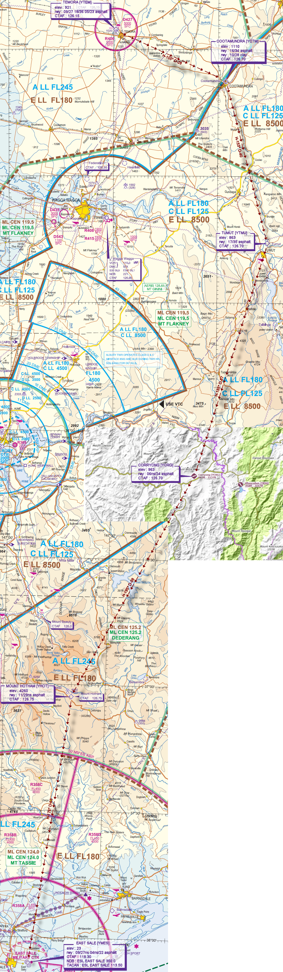
File as : YTEM YCTM YTMU YCRG YHOT YMES
GPS Flightplan is available for FSX and X-Plane FMS and also provided is the original Plan-G flightplan for those that find this useful all enclosed within a Zip archive.
Navigation : Pilots familiar with the area can navigate visually, for those less familiar the accompanying GPS Flightplan is the recommended method of navigating the flight plan.
Recommended Scenery
Flight Details
-
TEMORA [YTEM] Takeoff
elev : 921
rwy : 09/27 18/36 05/23 asphalt
CTAF : 126.15 -
COOTAMUNDRA [YCTM] T&G - H-105° D-28.3 nm
elev : 1110
rwy : 16/34 asphalt
rwy : 10/28 clay
CTAF : 126.70 -
TUMUT [YTMU] T&G - H-153° D-39.7 nm
elev : 863
rwy : 17/35 asphalt
CTAF : 126.70 -
CORRYONG [YCRG] T&G - H-185° D-57.8 nm
elev : 963
rwy : 06ns/24 asphalt
CTAF : 126.70 -
MOUNT HOTHAM [YHOT] T&G - H-195° D-58.4 nm
elev : 4260
rwy : 11/29ns asphalt
CTAF : 126.75 -
EAST SALE [YMES] Land - H-176° D-63.6 nm
elev : 23
rwy : 09/27ns 04ns/22 asphalt
CTAF : 118.30
NDB : ESL EAST SALE 350.0
TACAN : ESL EAST SALE 113.50
Chart