Event created by Russell D - 1104622

Event Details
Simulation Date/Time : Current date set to daylight.
Weather : Real World / Fair weather if real world is unsuitable for VFR operations.
Distance : 236 nm
Est Flight Time : approx 85 mins
Aircraft : Twin Engine aircraft, preferrably amphibious such as Grumman Goose, Canadair CL-215/415, DC-3 (as a non-amphibious option) or similar capable of 160 to 200 kias.
Communications : Australia uses CTAF (Common Traffic Advisory Frequency) for radio comms at uncontrolled airfields. VATSIM pilots connecting to the network using FSCOPILOT/FSINN can install an additional file that provides the ability to tune the CTAF frequency and make voice announcements to other pilots on frequency. These files can be obtained via this link.
Altitude : upto 9500
Flightplan
File as : YKBR YMWA YMRW YMEW CLIFF-HEAD YGEL
No GPS Flightplan is provided for this flight.
Navigation : Pilots will be required to fly without the assistance of a GPS flightplan. Navigational references to Geraldton VOR/DME is included to assist.
Recommended Scenery
- Geraldton YGEL
- Alan Blencoe - Kalbarri Airport - Required
- Alan Blencoe - Mullewa - Required
- ORBX Australia
- ANTS AUSSIE AIRPORTS
- OZX AU Scenery
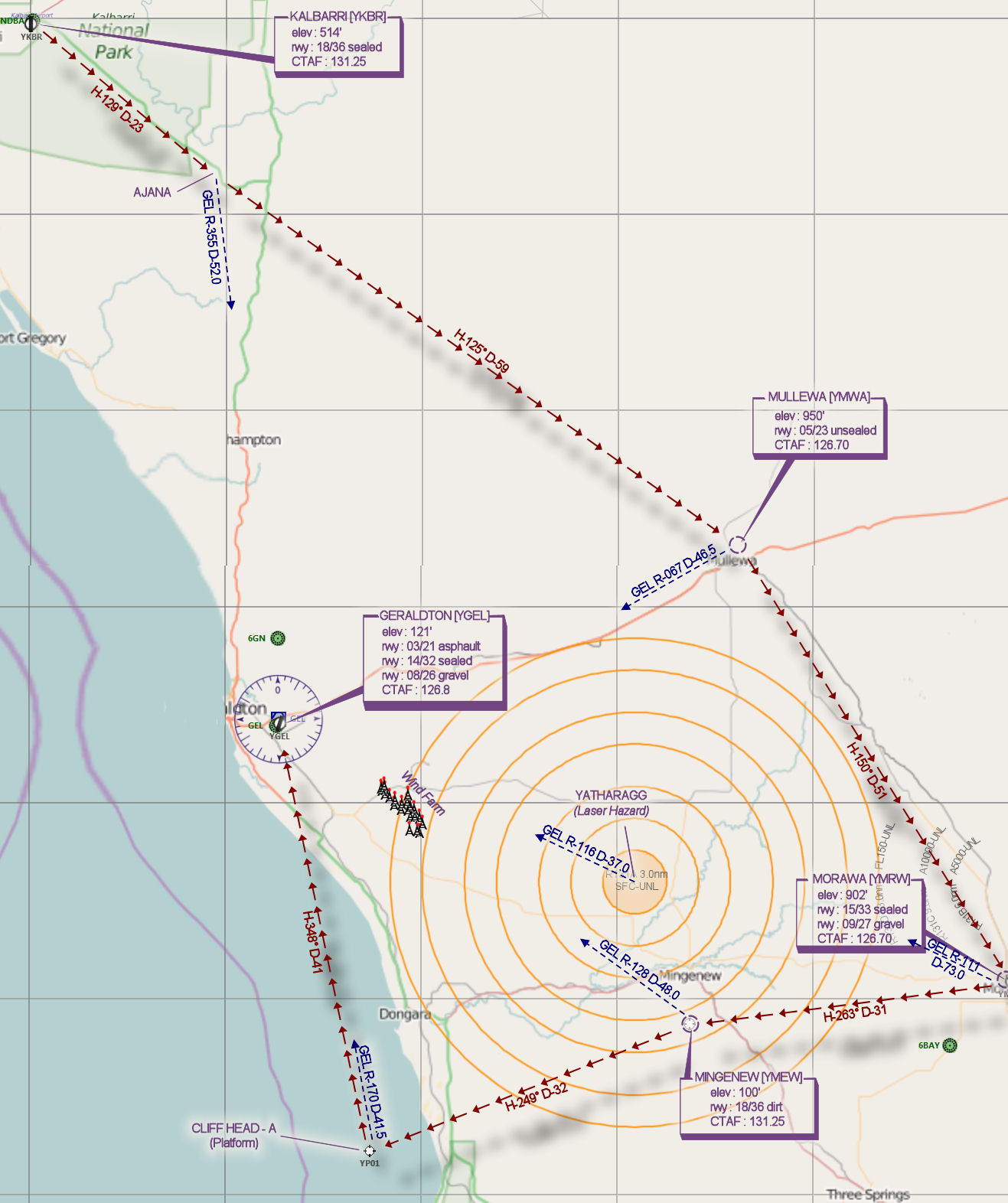
Flight Details
-
KALBARRI [YKBR] Takeoff
elev : 514'
rwy : 18/36 sealed
CTAF : 131.25
-
AJANA Overfly - H-129° D-23
pos : GEL R-355 D-52.0
-
MULLEWA [YMWA] T&G - H-125° D-59
pos : GEL R-067 D-46.5
elev : 950'
rwy : 05/23 unsealed
CTAF : 126.70
-
MORAWA [YMRW] T&G - H-150° D-51
pos : GEL R-111 D-73.0
elev : 902'
rwy : 15/33 sealed
rwy : 09/27 gravel
CTAF : 126.70
-
MINGENEW [YMEW] T&G - H-263° D-31
pos : GEL R-128 D-48.0
elev : 100'
rwy : 18/36 dirt
CTAF : 131.25
-
CLIFF HEAD A [Platform] Splash & Go - H-249° D-32
pos : GEL R-170 D-41.5
-
GERALDTON [YGEL] Land - H-348° D-41
elev : 121'
rwy : 03/21 asphault
rwy : 14/32 sealed
rwy : 08/26 gravel
CTAF : 126.8
VOR/DME : GEL 113.90
NDB : GEL 359.0
Chart