Event created by Russell D - 1104622

Event Details
Simulation Date/Time : Current date set to daylight.
Weather : Real World / Fair weather if real world is unsuitable for VFR operations.
Distance : 172nm
Est Flight Time : approx 80 mins
Aircraft : Single or twin engine aircraft such as Beechcraft Baron, Mooney Bravo or similar capable of 155 to 185 kias.
Communications : Australia uses CTAF (Common Traffic Advisory Frequency) for radio comms at uncontrolled airfields. VATSIM pilots connecting to the network using FSCOPILOT/FSINN can install an additional file that provides the ability to tune the CTAF frequency and make voice announcements to other pilots on frequency. These files can be obtained via this link.
For pilots connecting to VATSIM using VPilot, there is a work around that enables these pilots to also take advantage of online voice CTAF. Refer to this informative VATPAC Forum post to learn how to implement the work around.
Altitude : Below Brisbane and Sunshine Coast CTA steps
Flightplan
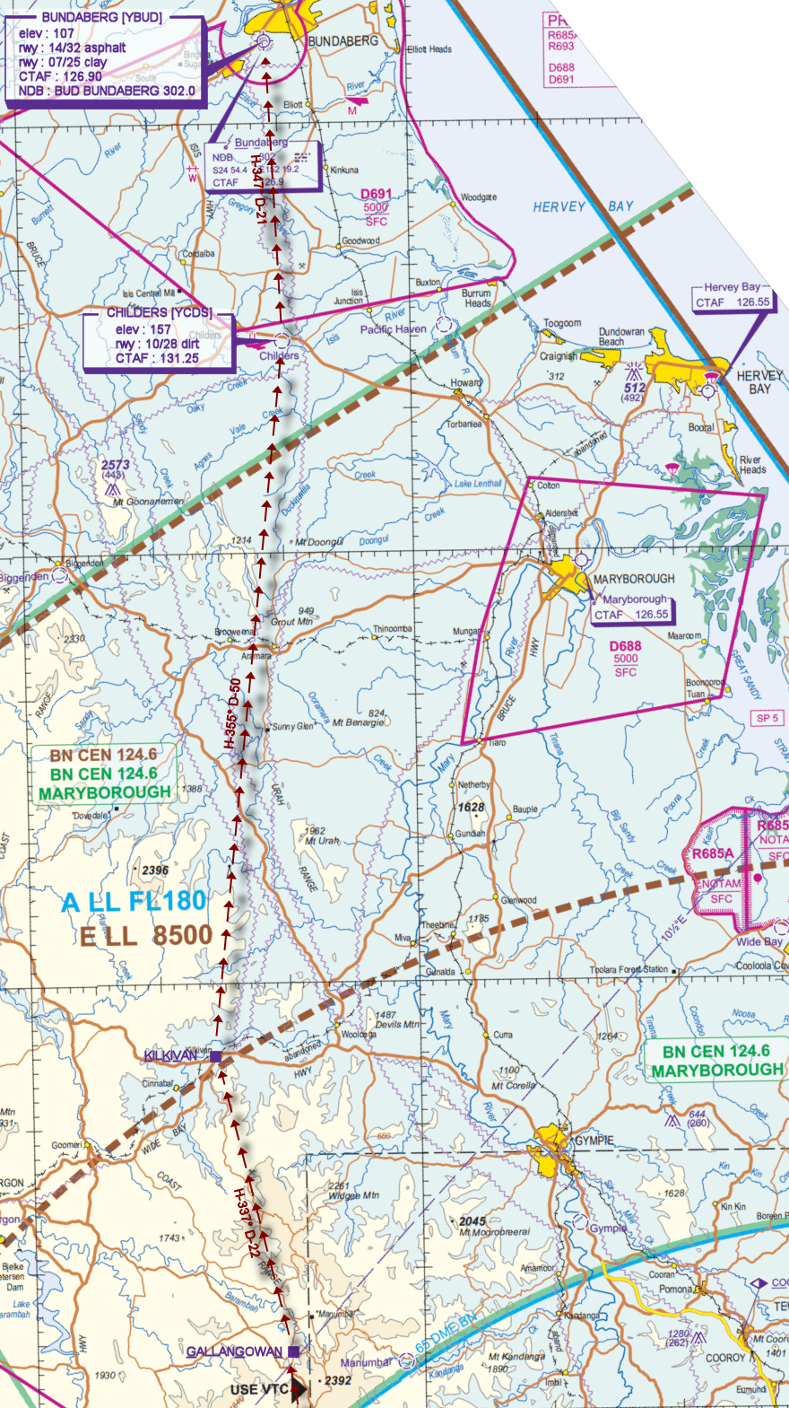
File as : YBAF WTBG SSV YSMS YKCY GGN KKV YCDS YBUD
GPS Flightplan is available for FSX and X-Plane FMS and also provided is the original Plan-G flightplan for those that find this useful all enclosed within a Zip archive.
Navigation : Pilots familiar with the area can navigate visually, for those less familiar the accompanying GPS Flightplan is the recommended method of navigating the flight plan.
Recommended Scenery
Flight Details
-
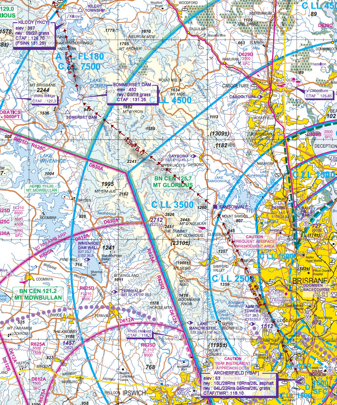
ARCHERFIELD [YBAF] Takeoff
elev : 63
rwy : 10L/28Rns 10Rns/28L asphalt
rwy : 04L/22Rns 04Rns/28L grass
CTAF/TWR : 118.10 -
WALTER TAYLOR BRIDGE [WTBG] Overfly - H-324° D-4.3 nm
-
SAMSONVALE [SSV] Overfly - H-324° D-15 nm
-
SOMMERSET DAM T&G - H-298° D-17.3 nm
elev : 452
rwy : 01/19 grass
CTAF : 131.25 -
KILCOY [YKCY] T&G - H-335° D-7.9 nm
elev : 387
rwy : 09/27 grass
CTAF : 126.70 (FSINN 131.25) -
GALLANGOWAN [GGN] Overfly - H-328° D-34.7 nm
-
KILKIVAN [KKV] Overfly - H-337° D-21.5 nm
-
CHILDERS [YCDS] T&G - H-355° D-50.1 nm
elev : 157
rwy : 10/28 dirt
CTAF : 131.25 -
BUNDABERG [YBUD] Land - H-347° D-21 nm
elev : 107
rwy : 14/32 asphalt
rwy : 07/25 clay
CTAF : 126.90
NDB : BUD BUNDABERG 302.0
Brisbane VTC
Bundaburg VNC