

Event created by Russell D - 1104622

Event Details
Simulation Date/Time : Current date set to daylight.
Weather : Real World / Fair weather if real world is unsuitable for VFR operations.
Distance :123 nm
Est Flight Time : approx 70 mins
Aircraft :Single or twin engine piston aircraft such as Mooney Bravo, Beechcraft Baron 58 or similar capable of 150 to 165 kias.
Communications : Australia uses CTAF (Common Traffic Advisory Frequency) for radio comms at uncontrolled airfields. VATSIM pilots connecting to the network using FSCOPILOT/FSINN can install an additional file that provides the ability to tune the CTAF frequency and make voice announcements to other pilots on frequency. These files can be obtained via this link.
Altitude : Not above FL125
Navigation : Pilots have a choice of alternatives for this flight. There is the obligatory accompanying flight plan for those that embrace the latest technology. For the more adventurous pilots the radial and distances are provided allowing the flight to be navigated using ground based radio and visual navigation techniques.
GPS Flightplan is available for FSX and X-Plane FMS and also provided is the original Plan-G flightplan for those that find this useful all enclosed within a Zip archive.
Flight Details
-
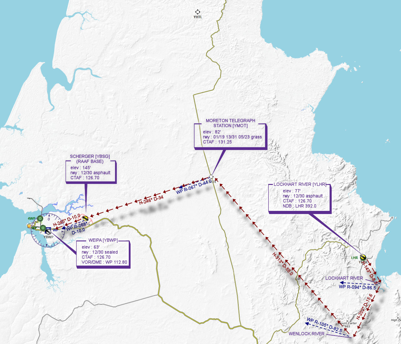
LOCKHART RIVER [YLHR] Takeoff
elev : 77'
rwy : 12/30 asphault
CTAF : 126.70
NDB : LHR 392.0 -
LOCKHART RIVER Overfly - H-143° D-8.3 nm
pos : WP R-094° D-86.5 -
WENLOCK RIVER Overfly - H-202° D-15.6 nm
pos : WP R-105° D-82.5 -
MORETON TELEGRAPH STATION [YMOT] T&G - H-313° D-54.9 nm
pos : WP R-067° D-44.0
elev : 82'
rwy : 01/19 13/31 05/23 grass
CTAF : 131.25 -
SCHERGER [YBSG] T&G - H-246° D-34 nm
pos : WP R-068° D-10.0
elev : 145'
rwy : 12/30 asphault
CTAF : 126.70 -
WEIPA [YBWP] Land - H-245° D-10.1 nm
elev : 63'
rwy : 12/30 sealed
CTAF : 126.70
VOR/DME : WP 112.80
Chart
Recommended Scenery
Flightplan
File as : YLHR YMOT YBSG YBWP
GPS Flightplan is available for FSX and X-Plane FMS and also provided is the original Plan-G flightplan for those that find this useful all enclosed within a Zip archive.