Event created by Russell D - 1104622

Event Details
Simulation Date/Time : Current date set to daylight.
Weather : Real World / Fair weather if real world is unsuitable for VFR operations.
Distance : 131 nm
Est Flight Time : approx 85 mins
Aircraft : Single engine aircraft such as Orion Maule, Cessna 172 or similar capable of 115 to 135 kias.
Altitude : Remain below Williamtown restricted airspace
Flightplan
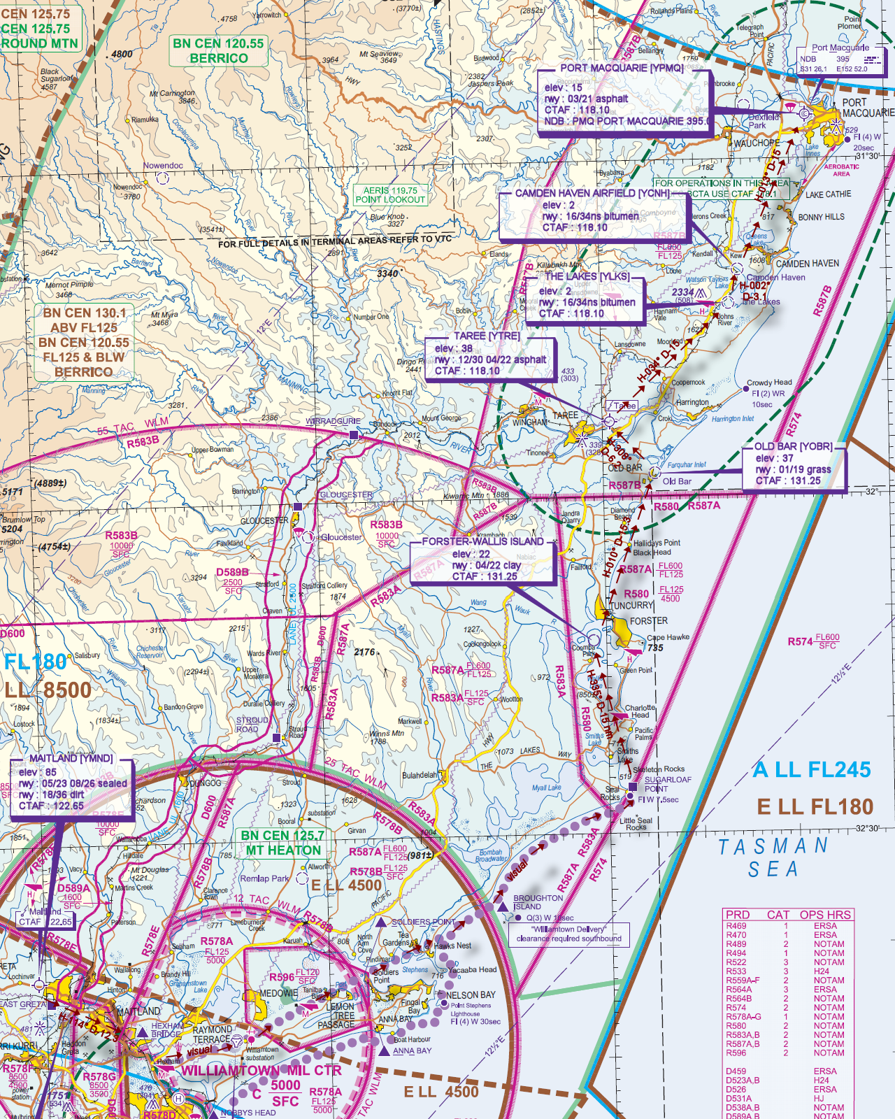
File as : YMND HXB YWLM BRI SUG WALLIS YOBR YTRE YLKS YCNH YPMQ
GPS Flightplan is available for FSX and X-Plane FMS and also provided is the original Plan-G flightplan for those that find this useful all enclosed within a Zip archive.
Navigation : Pilots familiar with the area can navigate visually, for those less familiar the accompanying GPS Flightplan is the recommended method of navigating the flight plan.
Communications
Australia uses CTAF (Common Traffic Advisory Frequency) for radio comms at uncontrolled airfields. Now that VATSIM has introduced AFV (Audio For VATSIM) CTAF can now be used across all VATSIM approved pilot clients. Pilots are requested to tune to the published frequency as detailed in the flight details for an event when operating in or around an aerodome to make and monitor CTAF broadcasts. Pilots should also be aware that it is a VATSIM COC (Code of Conduct) requirement that all pilots at uncontrolled airfields should monitor Unicom (Australia 122.80). It is highly recommended that pilots ensure that at least one of their "on board" COM radios (COM 2 being the most likely) is tuned to receive unicom transmissions in addition to transmitting and receiving on the published CTAF frequency. Please Note. All pilots should also be vigilant regarding the receipt of text on both unicom and CTAF. If it is discovered there is a pilot participating that is unable to receive voice transmissions, pilots should arrange to also broadcast via text to ensure those pilots without the benefit of voice is able to receive appropriate broadcasts. VATSIM provides an update guide for getting AFV working on each of the approved pilot clients.
Pilots also should read this post regarding the implications of using VATSIM UNICOM for CTAF. It provides some insight into potential pitfalls for the unwary when monitoring 122.80 in a CTAF environment.
Recommended Scenery
FSX / P3D
- Port Macquarie
- ORBX Australia
- ANTS AUSSIE AIRPORTS
- OZX 3.5 AU Scenery
- OZX Libraries 1.2 (required for all OZX scenery)
X-Plane 10/11
Flight Details
-
MAITLAND [YMND] Takeoff
elev : 85
rwy : 05/23 08/26 sealed
rwy : 18/36 dirt
CTAF : 122.65 -
HEXHAM BRIDGE [HXB] Overfly - H-114° D-12.3 nm
if Williamtown airspace active, request transition from controller -
WILLIAMTOWN MILITARY [YWLM] if airspace is active Overfly otherwise T&G pilot's discretion - H-065° D-7.8 nm
elev : 31
rwy : 12/30 asphalt
CTAF : 118.30
NDB : WLM WILLIAMTOWN NEWCASTLE 365.0
TACAN : WLM WILLIAMTOWN NEWCASTLE 113.30 -
BROUGHTON ISLAND [BRI] Overfly - H-053° D-26.5 nm
-
SUGARLOAF POINT [SUG] Overfly - via the coast
-
FORSTER-WALLIS ISLAND T&G - H-335° D-14.9 nm
elev : 22
rwy : 04/22 clay
CTAF : 131.25 -
OLD BAR [YOBR] T&G - H-010° D-15.3 nm
elev : 37
rwy : 01/19 grass
CTAF : 131.25 -
TAREE [YTRE] T&G - H-308° D-6.2 nm
elev : 38
rwy : 12/30 04/22 asphalt
CTAF : 118.10 -
THE LAKES [YLKS] T&G - H-034° D-14.9 nm
elev : 2
rwy : 16/34ns bitumen
CTAF : 118.10 -
CAMDEN HAVEN AIRFIELD [YCMH] T&G - H-002° D-3.1 nm
elev : 20
rwy : 12/30ns grass
CTAF : 118.10 -
PORT MACQUARIE [YPMQ] Land - H-013° D-15.1 nm
elev : 15
rwy : 03/21 asphalt
CTAF : 118.10
NDB : PMQ PORT MACQUARIE 395.0
Chart