

Event created by Russell D - 1104622

Event Details
Simulation Date/Time : Current date set to daylight.
Weather : Real World / Fair weather if real world is unsuitable for VFR operations.
Distance : 135 nm
Est Flight Time : approx 80 mins
Aircraft : Single engine piston aircraft such as Cessna 172 or similar capable of 105 to 135 kias. This flight is also suitable for helicopter operations as well should the pilot wish to get close and personal to the local scenery.
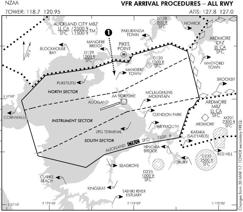
Altitude : Remain outside Auckland International CTA
Flightplan
File as : NZNE NZHB BLOCKHOUSE.BAY NZMB HORWICK NZKE NZCX NZAG NZGR NZNE
GPS Flightplan is available for FSX and X-Plane FMS and also provided is the original Plan-G flightplan for those that find this useful all enclosed within a Zip archive.
Navigation : Pilots familiar with the area can navigate visually, for those less familiar the accompanying GPS Flightplan is the recommended method of navigating the flight plan.
Communications
New Zealand uses CTAF (Common Traffic Advisory Frequency) for radio comms at uncontrolled airfields. Now that VATSIM has introduced AFV (Audio For VATSIM) CTAF can now be used across all VATSIM approved pilot clients. Pilots are requested to tune to the published frequency as detailed in the flight details for an event when operating in or around an aerodome to make and monitor CTAF broadcasts. Pilots should also be aware that it is a VATSIM COC (Code of Conduct) requirement that all pilots at uncontrolled airfields should monitor Unicom (Australia 122.80). It is highly recommended that pilots ensure that at least one of their "on board" COM radios (COM 2 being the most likely) is tuned to receive unicom transmissions in addition to transmitting and receiving on the published CTAF frequency. Please Note. All pilots should also be vigilant regarding the receipt of text on both unicom and CTAF. If it is discovered there is a pilot participating that is unable to receive voice transmissions, pilots should arrange to also broadcast via text to ensure those pilots without the benefit of voice is able to receive appropriate broadcasts. VATSIM provides an update guide for getting AFV working on each of the approved pilot clients.
Pilots also should read this post regarding the implications of using VATSIM UNICOM for CTAF. It provides some insight into potential pitfalls for the unwary when monitoring 122.80 in a CTAF environment.
Recommended Scenery
FSX / P3D
X-Plane 10/11
Auckland International Airport
Observe altitude restrictions whilst in close proximity to the airport
Flight Details
-
NORTH SHORE [NZNE] Takeoff
elev : 212
rwy : 09/27 03/21 asphalt
CTAF : 118.00 -
HOBSONVILLE AERO [NZHB] T&G - H-157° D-8 nm
elev : 59
rwy : 05/23 10/28 14/32 grass
CTAF : 122.80 -
HENDERSON Overfly - H-181° D-5.3 nm
-
GREEN BAY Overfly - H-127° D-4.2 nm
-
BLOCKHOUSE BAY Overfly - H-048° D-1.3 nm
-
MECHANICS BAY HELIPORT [NZMB] Overfly - H-023° D-6.2 nm
CTAF : 122.80 -
HORWICK Overfly - H-088° D-7 nm
-
WAIHEKE [NZKE] T&G - H-041° D-8.8 nm
elev : 445
rwy : 17/35 dirt
CTAF : 120.40 -
COROMANDEL [NZCX] T&G - H-068° D-20.3 nm
elev : 13
rwy : 12/30 dirt
CTAF : 124.50 -
MATARANGI [NZAG] T&G - H-042° D-7.7 nm
elev : 6
rwy : 03/21 grass
CTAF : 122.80 -
GREAT MERCURY AIRPORT [NZGR] T&G - H-016° D-9.7 nm
elev : 177
rwy : 14/32 grass
CTAF : 122.80 -
FLETCHER BAY Overfly - H-273° D-19.6 nm
-
NORTH SHORE [NZNE] Land - H-234° D-37 nm
elev : 212
rwy : 09/27 03/21 asphalt
CTAF : 118.00
Chart
