

Event created by Russell D - 1104622

Event Details
Simulation Date/Time : Current date set to daylight.
Weather : Real World / Fair weather if real world is unsuitable for VFR operations.
Distance : 100 nm
Est Flight Time : approx 70 to 80 mins depending on whether a touch and go is conducted at NZAA
Aircraft : Single engine piston aircraft such as Cessna 172 or similar capable of 105 to 135 kias. This flight is also suitable for helicopter operations as well should the pilot wish to get close and personal to the local scenery.
Communications : Australia uses CTAF (Common Traffic Advisory Frequency) for radio comms at uncontrolled airfields. VATSIM pilots connecting to the network using FSCOPILOT/FSINN can install an additional file that provides the ability to tune the CTAF frequency and make voice announcements to other pilots on frequency. These files can be obtained via this link.
For pilots connecting to VATSIM using VPilot, there is a work around that enables these pilots to also take advantage of online voice CTAF. Refer to this informative VATPAC Forum post to learn how to implement the work around.
Note : Voice support in New Zealand is limited to general unicom only. This flight uses unicom "rw1.vatpac.org/UNICOM_NZZC"
Altitude : Remain outside Auckland International CTA for the most part. Obtain ATC clearance prior to overflying or executing a touch and go at Auckland.
Flightplan
File as : NZNE NZKE NZAR NZME NZAA NZNE
GPS Flightplan is available for FSX and X-Plane FMS and also provided is the original Plan-G flightplan for those that find this useful all enclosed within a Zip archive.
Navigation : Pilots familiar with the area can navigate visually, for those less familiar the accompanying GPS Flightplan is the recommended method of navigating the flight plan.
Recommended Scenery
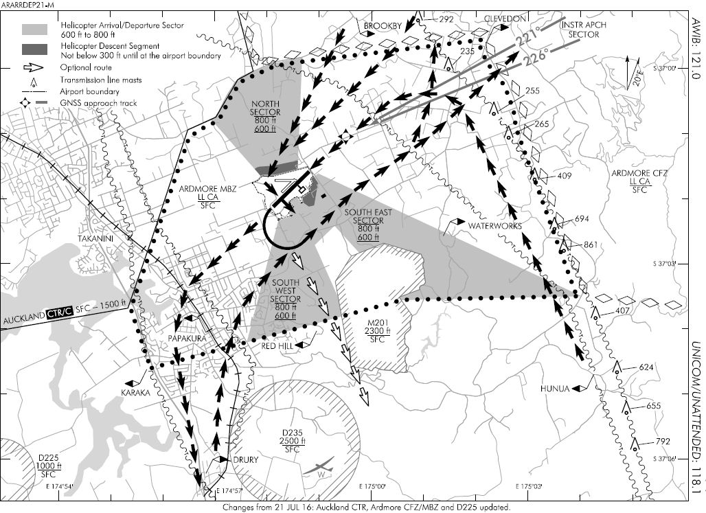
Ardmore GA Airport
Observe entry and departure corridors whilst operating in the airport's airspace.
Auckland International Airport
Observe altitude restrictions whilst in close proximity to the airport. Obtain ATC clearance if active prior to entering the CTA
Flight Details
-
NORTH SHORE [NZNE] Takeoff
elev : 212
rwy : 09/27 03/21 asphalt
CTAF : 122.80 -
WAIHEKE [NZKE] T&G - H-095° D-22.6 nm
elev : 445
rwy : 17/35 dirt
CTAF : 122.80 -
BROOKBY Overfly - H-184° D-11.5 nm
Note : Inbound VISUAL REFERENCE for entry into Ardmore -
ARDMORE [NZAR] T&G - H-178° D-2.8 nm
elev : 111
rwy : 07/25 03/21 asphalt
CTAF : 122.80
Depart to the south abeam "RED HILL" -
MERCER [NZME] T&G - H-134° D-15.3 nm
elev : 30
rwy : 09/27 dirt
CTAF : 122.80 -
KELLY FIELD [NZKC] T&G - H-256° D-2 nm
elev : 49
rwy : 06/24 dirt
CTAF : 122.80 -
PUKEKOHE Overfly - H-275° D-8.7 nm
-
TAIHIKI RIVER ESTUARY Overfly - H-271° D-6 nm
INBOUND VISUAL REFERENCE for entry into Auckland International. Make inbound ATC call with reference to this VRP/ALT and NZAA ATIS IDENTIFIER to either transistion to the North via Auckland CBD or Touch and Go departing NE via Auckland CBD -
AUCKLAND INTL [NZAA]Overfly OR T&G at Pilot's discretion - H-322° D-9.2 nm
elev : 23
rwy : 05R/23L asphalt
CTAF : 122.80
VOR/DME : AA AUCKLAND 114.80 -
AUCKLAND CBD Overfly - H-331° D-8.9 nm
-
ALBANY Overfly - H-319° D-8.8 nm
-
NORTH SHORE [NZNE] Land - H-315° D-4.6 nm
elev : 212
rwy : 09/27 03/21 asphalt
CTAF : 122.80
Chart
