Event created by Russell D - 1104622

Event Details
Simulation Date/Time : Current date set to daylight.
Weather : Real World / Fair weather if real world is unsuitable for VFR operations.
Distance : 228 nm
Est Flight Time : approx 80 mins
Aircraft : WWII military fighter aircraft such as P51 Mustang, Supermarine Spitfire or similar capable of 190 to 250 kias
Altitude : Upto A9500
Flightplan
File as : YSRI BRY YSCN YWOL YGLB GUNN ASST YCTM YTEM
GPS Flightplan is available for FSX, P3D, FS2020 as a 'pln' file and X-Plane as an 'fms' file. The original Plan-G flightplan is also included for those that find this useful. These are all enclosed within a Zip archive.
Navigation : Pilots familiar with the area can navigate visually, for those less familiar the accompanying GPS Flightplan is the recommended method of navigating the flight plan.
Communications
Australia uses CTAF (Common Traffic Advisory Frequency) for radio comms at uncontrolled airfields. Now that VATSIM has introduced AFV (Audio For VATSIM) CTAF can now be used across all VATSIM approved pilot clients. Pilots are requested to tune to the published frequency as detailed in the flight details for an event when operating in or around an aerodome to make and monitor CTAF broadcasts. Pilots should also be aware that it is a VATSIM COC (Code of Conduct) requirement that all pilots at uncontrolled airfields should monitor Unicom (Australia 122.80). It is highly recommended that pilots ensure that at least one of their "on board" COM radios (COM 2 being the most likely) is tuned to receive unicom transmissions in addition to transmitting and receiving on the published CTAF frequency. Please Note. All pilots should also be vigilant regarding the receipt of text on both unicom and CTAF. If it is discovered there is a pilot participating that is unable to receive voice transmissions, pilots should arrange to also broadcast via text to ensure those pilots without the benefit of voice is able to receive appropriate broadcasts. VATSIM provides an update guide for getting AFV working on each of the approved pilot clients.
Pilots also should read this post regarding the implications of using VATSIM UNICOM for CTAF. It provides some insight into potential pitfalls for the unwary when monitoring 122.80 in a CTAF environment.
Recommended Scenery
FSX / P3D
- ORBX Australia
- ANTS AUSSIE AIRPORTS
- OZX 3.5 AU Scenery
- OZX Libraries 1.2 (required for all OZX scenery)
X-Plane 10/11
Flight Details
-
RICHMOND MILITARY [YSRI] Takeoff
elev : 67
rwy : 10/28 asphalt
CTAF : 135.50
TACAN : RIC RICHMOND 110.70
NDB : RIC RICHMOND 347.0 -
BRINGELLY [BRY] Overfly - H-175° D-21 *INBOUND REPORTING POINT for CAMDEN
if TWR active : CAMDEN TOWER, [CALLSIGN][AIRCRAFT TYPE] BRINGELLY 1700 RECEIVED INFORMATION [ATIS IDENTIFIER] INBOUND TOUCH AND GO DEPARTURE SOUTH -
CAMDEN [YSCN] T&G - H-186° D-6
elev : 230
rwy : 06/24 asphalt
rwy : 10/28 grass
CTAF : 120.10 -
WOLLONGONG [YWOL] T&G - H-158° D-32
elev : 31
rwy : 08/26ns 16/34ns asphalt
* ns : non-standard right circuit
CTAF : 127.30
NDB : WOL WOLLONGONG 239.0 -
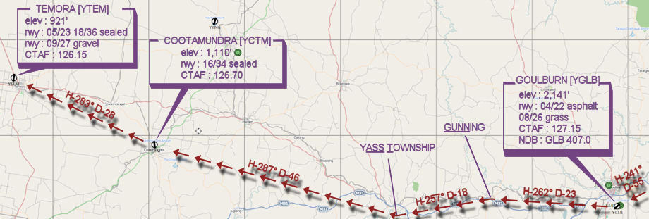
GOULBURN [YGLB] T&G - H-241° D-55
elev : 2141
rwy : 04/22 asphalt
rwy : 08/26 grass
CTAF : 127.15
NDB : GLB GOULBURN 407.0 -
GUNNING [GUNN] Overfly - H-262° D-23
-
YASS TOWNSHIP [ASST] Overfly - H-244° D-18
-
COOTAMUNDRA [YCTM] T&G - H-274° D-46
elev : 1110
rwy : 16/34 asphalt
rwy : 10/28 clay
CTAF : 126.70 -
TEMORA [YTEM] Land - H-283° D-28
elev : 921
rwy : 09/27 18/36 05/23 asphalt
CTAF : 126.15
Visual Terminal Chart

WAN Chart