Event created by Russell D - 1104622

Event Details
Simulation Date/Time : Current date set to daylight.
Weather : Real World / Fair weather if real world is unsuitable for VFR operations.
Distance : 215 nm
Est Flight Time : approx 80 mins
Aircraft : Twin engine aircraft such as Beechcraft Baron or similar capable of 155 to 185 kias.
Communications : Australia uses CTAF (Common Traffic Advisory Frequency) for radio comms at uncontrolled airfields. VATSIM pilots connecting to the network using FSCOPILOT/FSINN can install an additional file that provides the ability to tune the CTAF frequency and make voice announcements to other pilots on frequency. These files can be obtained via this link.
For pilots connecting to VATSIM using VPilot, there is a work around that enables these pilots to also take advantage of online voice CTAF. Refer to this informative VATPAC Forum post to learn how to implement the work around.
Altitude : Not above FL125
Flightplan
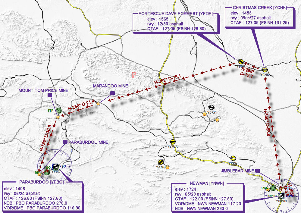
File as : YNWN YCHK YFDF MARANDOO TOM.PRICE YPBO
GPS Flightplan is available for FSX and X-Plane FMS and also provided is the original Plan-G flightplan for those that find this useful all enclosed within a Zip archive.
Navigation : Due to the lack of visual references pilots are encouraged to navigate using the accompanying GPS Flightplan.
Recommended Scenery
- REQUIRED - OZx Pilbara Region Airports WA - - NOTE - There is a potential of a clash with YFDF and YCWA if the corresponding Alan Blencoe scenery is in installed. If so consider deactivating the Alen Blencoe or Robert Fluke so only one for each is active.
- ORBX Australia
- ANTS AUSSIE AIRPORTS
- OZX AU Scenery
Flight Details
-
NEWMAN [YNWN] Takeoff
elev : 1724
rwy : 05/23 asphalt
CTAF : 122.00 (FSINN 127.60)
VOR/DME : NWN NEWMAN 117.20
NDB : NWN NEWMAN 233.0 -
JIMBLEBAR MINE Overfly - H-355° D-5.5 nm
-
CHRISTMAS CREEK [YCHK] T&G - H-350° D-58.8 nm
elev : 1453
rwy : 09ns/27 asphalt
CTAF : 127.05 (FSINN 131.25) -
FORTESCUE DAVE FORREST [YFDF] T&G - H-286° D-12.7 nm
elev : 1565
rwy : 12/30 asphalt
CTAF : 127.05 (FSINN 126.80) -
MARANDOO MINE Overfly - H-252° D-75.1 nm
-
MOUNT TOM PRICE MINE Overfly - H-250° D-21.4 nm
-
PARABURDOO MINE Overfly - H-196° D-30.3 nm
-
PARABURDOO [YPBO] Land - H-064° D-8.9 nm
elev : 1406
rwy : 06/24 asphalt
CTAF : 126.80 (FSINN 127.60)
NDB : PBO PARABURDOO 278.0
VOR/DME : PBO PARABURDOO 116.90
Chart