Event created by Russell D - 1104622

Event Details
Simulation Date/Time : Current date set to daylight.
Weather : Real World / Fair weather if real world is unsuitable for VFR operations.
Distance : 160 nm
Est Flight Time : approx 80 mins
Aircraft : Single or twin engine aircraft such as Beechcraft Baron, Cessna Caravan or similar capable of 155 to 165 kias.
Altitude : Below Perth CTA steps and remain clear of Pearce Restricted Airspace
Flightplan
File as : YPJT VFR.4 LANCELIN.ISL VFR.1 YCVS VFR.2 VFR.1 YJUR YLEA
GPS Flightplan is available for FSX, P3D, FS2020 as a 'pln' file and X-Plane as an 'fms' file. The original Plan-G flightplan is also included for those that find this useful. These are all enclosed within a Zip archive.
Navigation : Pilots familiar with the area can navigate visually, for those less familiar the accompanying GPS Flightplan is the recommended method of navigating the flight plan.
Communications
Australia uses CTAF (Common Traffic Advisory Frequency) for radio comms at uncontrolled airfields. Now that VATSIM has introduced AFV (Audio For VATSIM) CTAF can now be used across all VATSIM approved pilot clients. Pilots are requested to tune to the published frequency as detailed in the flight details for an event when operating in or around an aerodome to make and monitor CTAF broadcasts. Pilots should also be aware that it is a VATSIM COC (Code of Conduct) requirement that all pilots at uncontrolled airfields should monitor Unicom (Australia 122.80). It is highly recommended that pilots ensure that at least one of their "on board" COM radios (COM 2 being the most likely) is tuned to receive unicom transmissions in addition to transmitting and receiving on the published CTAF frequency. Please Note. All pilots should also be vigilant regarding the receipt of text on both unicom and CTAF. If it is discovered there is a pilot participating that is unable to receive voice transmissions, pilots should arrange to also broadcast via text to ensure those pilots without the benefit of voice is able to receive appropriate broadcasts. VATSIM provides an update guide for getting AFV working on each of the approved pilot clients.
Pilots also should read this post regarding the implications of using VATSIM UNICOM for CTAF. It provides some insight into potential pitfalls for the unwary when monitoring 122.80 in a CTAF environment.
Recommended Scenery
FSX / P3D
- Required for Destination YLEA - Alan Blencowe's Complete Scenery Collection
- ORBX Perth Jandakot [YPJT]
- ORBX Australia
- ANTS AUSSIE AIRPORTS
- OZX 3.5 AU Scenery
- OZX Libraries 1.2 (required for all OZX scenery)
X-Plane 10/11
Jandakot Aerodrome
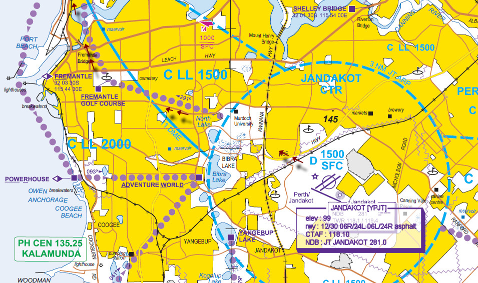
Jandakot Aerodrome services general aviation aircraft located in close proximity to Perth Internation Airport and Pearce Airbase further to the north.
For this flight we depart Jandakot to the north and track the VFR Route 4 along the coast to our destination of Leeman. For the purposes of this flight it will be assumed Pearce restricted airspace R146A is active will and require the use of VFR 1/VFR 2 to avoid infringing the airspace.
Scenery limitations
Jandakot recently underwent some changes when the 12/30 runway was extended. Any documentation at Air Services Australia in recent AIRACs will reflect these changes. Sadly, simulation scenery for P3D/FSX and X-Plane has failed to keep pace. Both simulations still depict Jandakot as displayed in the accompanying CASA manuevring chart displayed below.
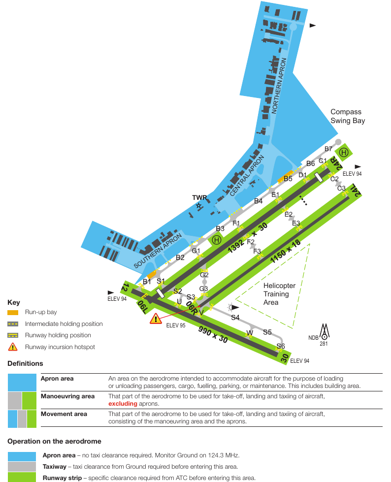
Airport Diagram is extracted from CASA Jandakot manoeuvring area map
Circuit Directions
Note : Circuit runway 24L/06R is only available when ATC is active
Tower Active
- RWY 06L - Left
- RWY 06R - Right
- RWY 24L - Left
- RWY 24R - Right
- RWY 12 - Left
- RWY 30 - Left
- ATC may at their discretion alter these. Also, when parallel operations are in progress, there may be one tower dedicated to the circuit runway 06R/24L as well as a tower dedicated to the main 06L/24R runway. Check with Jandakot ATIS pior to starting.
Tower Inactive
- RWY 06L - Right
- RWY 12 - Left
- RWY 24R - Left
- RWY 30 - Left
- RWY 24L/06R - Unavailable
Frequencies
- CTAF : 118.10
- TWR : 118.10 / 119.40
- SMC : 124.30
- ATIS : 128.65 / 281
- NDB : JT 281.0
Flight Details
-
JANDAKOT [YPJT] Takeoff
elev : 99
rwy : 12/30 06R/24L 06L/24R asphalt
CTAF : 118.10
NDB : JT JANDAKOT 281.0
IF ATC ACTIVE CALL - '[AIRCRAFT TYPE][CALLSIGN] [NORTHERN APRON|CENTRAL APRON|SOUTHERN APRON] REQUEST TAXI RUNWAY [DUTY RUNWAY] VFR DEPARTURE VIA Fremantle Golf Course'
At the hold point of the duty runway - "Ready hold point [DUTY RUNWAY] received [ATIS ID] for departure via Fremantle Golf Course [#]Persons On Board" -
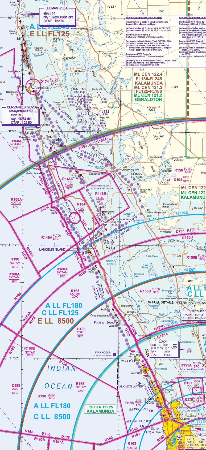
LANCELIN ISLAND Overfly - Coastal via VFR.4 D-72
-
SOUTH MARKER [SOUTH] Overfly - VFR.1 D-9
-
NORTH MARKER [NORTH] Overfly - VFR.1 D-11
-
CERVANTES [YCVS] T&G - VFR.1 D-20
(Scenery not depicted in P3D)
elev : 9
rwy : 16/34 dirt
CTAF : 122.80 -
NAMBUNG [NAMBU] Overfly - VFR.2 D-9
-
JURIEN BAY [YJUR] Overfly - VFR.1 D-18
(Scenery not depicted in P3D) -
LEEMAN [YLEA] Land - H-351° D-20
elev : 14
rwy : 02/20 13/31 dirt
CTAF : 122.80
PERTH Visual Navigation Chart (VNC)
JANDAKOT Visual Terminal Chart (VTC)