Event created by Russell D - 1104622

Event Details
Simulation Date/Time : Current date set to daylight.
Weather : Real World / Fair weather if real world is unsuitable for VFR operations.
Distance : 300 nm
Est Flight Time : approx 85 mins
Aircraft : Single or twin engine high performance aircraft such as Beechcraft Kingair, Mitsubishi Solitaire, Honda Jet or similar capable of 235 to 265 kias.
Communications : Australia uses CTAF (Common Traffic Advisory Frequency) for radio comms at uncontrolled airfields. VATSIM pilots connecting to the network using FSCOPILOT/FSINN can install an additional file that provides the ability to tune the CTAF frequency and make voice announcements to other pilots on frequency. These files can be obtained via this link.
For pilots connecting to VATSIM using VPilot, there is a work around that enables these pilots to also take advantage of online voice CTAF. Refer to this informative VATPAC Forum post to learn how to implement the work around.
Altitude : Not above FL125
Flightplan
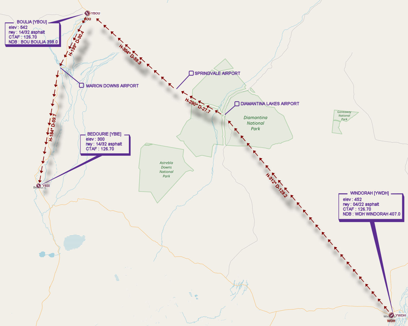
File as : YWDH YBOU YBIE
GPS Flightplan is available for FSX and X-Plane FMS and also provided is the original Plan-G flightplan for those that find this useful all enclosed within a Zip archive.
Navigation : Pilots familiar with the area can navigate visually, for those less familiar the accompanying GPS Flightplan is the recommended method of navigating the flight plan.
Recommended Scenery
Flight Details
-
WINDORAH [YWDH] Takeoff
elev : 452
rwy : 04/22 asphalt
CTAF : 126.70
NDB : WDH WINDORAH 407.0 -
DIAMANTINA LAKES AIRPORT Overfly - H-312° D-129.2 nm
(not depicted in FSX scenery) -
SPRINGVALE AIRPORT Overfly - H-290° D-27.7 nm
(not depicted in FSX scenery) -
BOULIA [YBOU] T&G - H-304° D-58.3 nm
elev : 542
rwy : 14/32 asphalt
CTAF : 126.70
NDB : BOU BOULIA 398.0 -
MARION DOWNS AIRPORT Overfly - H-199° D-30.4 nm
(not depicted in FSX scenery) -
BEDOURIE [YBIE] Land - H-184° D-59.7 nm
elev : 300
rwy : 14/32 asphalt
CTAF : 126.70
Chart